The Gap Sw Topo Map Wyoming
To zoom in, hover over the map of The Gap Sw
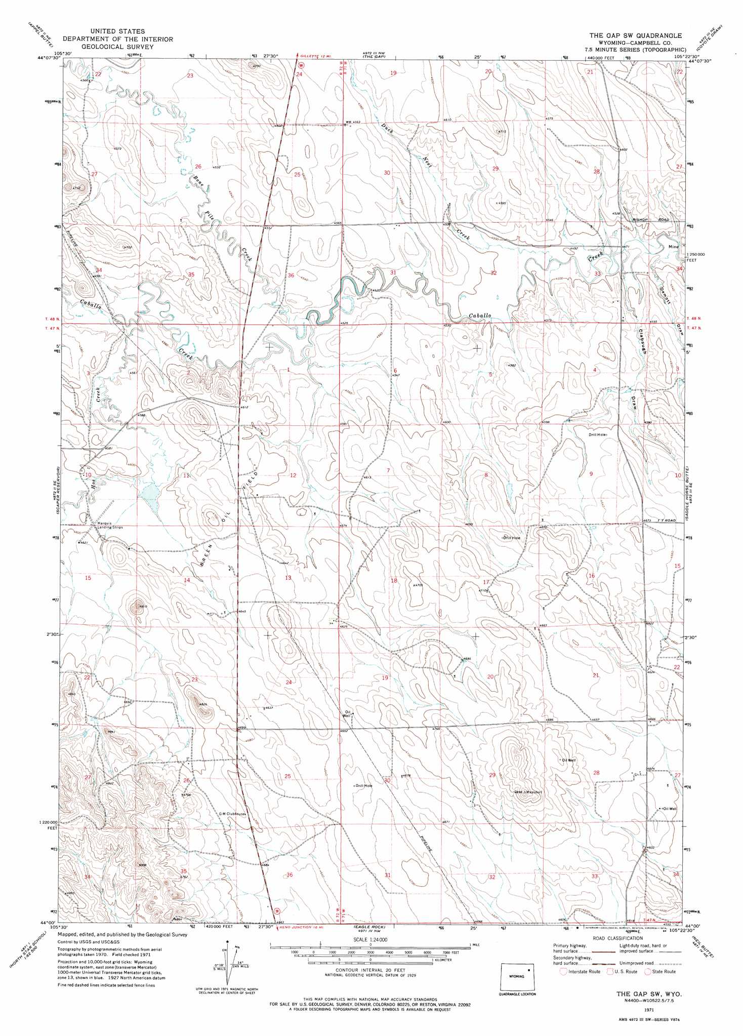
USGS Topo Quad 44105a4 - 1:24,000 scale
| Topo Map Name: | The Gap Sw |
| USGS Topo Quad ID: | 44105a4 |
| Print Size: | ca. 21 1/4" wide x 27" high |
| Southeast Coordinates: | 44° N latitude / 105.375° W longitude |
| Map Center Coordinates: | 44.0625° N latitude / 105.4375° W longitude |
| U.S. State: | WY |
| Filename: | o44105a4.jpg |
| Download Map JPG Image: | The Gap Sw topo map 1:24,000 scale |
| Map Type: | Topographic |
| Topo Series: | 7.5´ |
| Map Scale: | 1:24,000 |
| Source of Map Images: | United States Geological Survey (USGS) |
| Alternate Map Versions: |
The Gap SW WY 1971, updated 1974 Download PDF Buy paper map The Gap SW WY 1971, updated 1984 Download PDF Buy paper map The Gap SW WY 2012 Download PDF Buy paper map The Gap SW WY 2015 Download PDF Buy paper map |
1:24,000 Topo Quads surrounding The Gap Sw
Oriva |
Gillette West |
Gillette East |
Fortin Draw |
Rozet |
Four Bar J Ranch |
Appel Butte |
The Gap |
Coyote Draw |
Coon Track Creek |
Pleasantdale |
Scaper Reservoir |
The Gap Sw |
Saddle Horse Butte |
Whitetail Creek |
Pepsson Draw |
Threemile Creek Reservoir |
Eagle Rock |
Neil Butte |
Rough Creek |
Greasewood Reservoir |
Rocky Butte Gulch |
Reno Junction |
Hilight |
Open A Ranch |
> Back to 44105a1 at 1:100,000 scale
> Back to 44104a1 at 1:250,000 scale
> Back to U.S. Topo Maps home
The Gap Sw topo map: Gazetteer
The Gap Sw: Dams
Caballo Dam elevation 1377m 4517′Haight Dam elevation 1440m 4724′
Stone Number 1 Dam elevation 1386m 4547′
The Gap Sw: Mines
Geis Scoria Pit Number One elevation 1400m 4593′The Gap Sw: Oilfields
Breen Oil Field elevation 1417m 4648′The Gap Sw: Reservoirs
Caballo Reservoir elevation 1377m 4517′Haight Reservoir elevation 1440m 4724′
Stone Number 1 Reservoir elevation 1386m 4547′
The Gap Sw: Streams
Bone Pile Creek elevation 1372m 4501′Duck Nest Creek elevation 1366m 4481′
Hoe Creek elevation 1384m 4540′
The Gap Sw: Valleys
Clabaugh Draw elevation 1366m 4481′Demott Draw elevation 1363m 4471′
The Gap Sw digital topo map on disk
Buy this The Gap Sw topo map showing relief, roads, GPS coordinates and other geographical features, as a high-resolution digital map file on DVD:
Eastern Wyoming & Western South Dakota
Buy digital topo maps: Eastern Wyoming & Western South Dakota