Double Tanks Topo Map Wyoming
To zoom in, hover over the map of Double Tanks
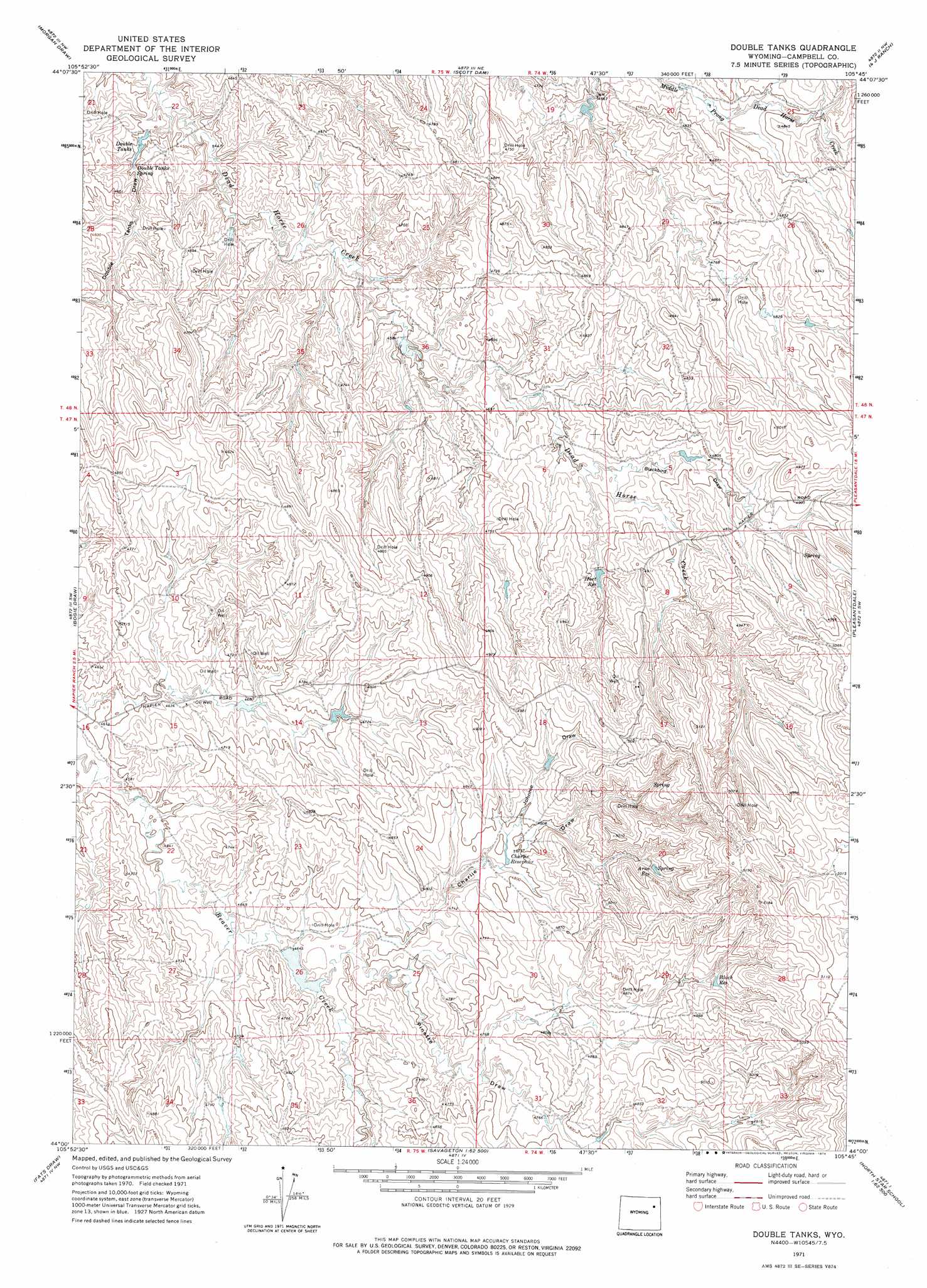
USGS Topo Quad 44105a7 - 1:24,000 scale
| Topo Map Name: | Double Tanks |
| USGS Topo Quad ID: | 44105a7 |
| Print Size: | ca. 21 1/4" wide x 27" high |
| Southeast Coordinates: | 44° N latitude / 105.75° W longitude |
| Map Center Coordinates: | 44.0625° N latitude / 105.8125° W longitude |
| U.S. State: | WY |
| Filename: | o44105a7.jpg |
| Download Map JPG Image: | Double Tanks topo map 1:24,000 scale |
| Map Type: | Topographic |
| Topo Series: | 7.5´ |
| Map Scale: | 1:24,000 |
| Source of Map Images: | United States Geological Survey (USGS) |
| Alternate Map Versions: |
Double Tanks WY 1971, updated 1974 Download PDF Buy paper map Double Tanks WY 2012 Download PDF Buy paper map Double Tanks WY 2015 Download PDF Buy paper map |
1:24,000 Topo Quads surrounding Double Tanks
Somerville Flats East |
Carr Draw |
Jeffers Draw |
Oriva |
Gillette West |
Laskie Draw |
Morgan Draw |
Scott Dam |
Four Bar J Ranch |
Appel Butte |
Negro Butte |
Bogie Draw |
Double Tanks |
Pleasantdale |
Scaper Reservoir |
The Nipple |
Fats Draw |
Wags Pinnacle |
Pepsson Draw |
Threemile Creek Reservoir |
Fort Reno Se |
North Butte |
Savageton |
Greasewood Reservoir |
Rocky Butte Gulch |
> Back to 44105a1 at 1:100,000 scale
> Back to 44104a1 at 1:250,000 scale
> Back to U.S. Topo Maps home
Double Tanks topo map: Gazetteer
Double Tanks: Dams
Charlie Dam elevation 1464m 4803′Double Tanks: Reservoirs
Arno Spring Reservoir elevation 1519m 4983′Black Reservoir elevation 1508m 4947′
Charlie Reservoir elevation 1464m 4803′
Charlie Reservoir elevation 1459m 4786′
Double Tanks elevation 1371m 4498′
Hart Reservoir elevation 1459m 4786′
Double Tanks: Springs
Double Tanks Spring elevation 1375m 4511′Double Tanks: Streams
North Beaver Creek elevation 1421m 4662′Double Tanks: Valleys
Blackbird Draw elevation 1441m 4727′Charlie Draw elevation 1427m 4681′
Double Tanks Draw elevation 1360m 4461′
Johnnie Draw elevation 1465m 4806′
Pinette Draw elevation 1459m 4786′
Double Tanks digital topo map on disk
Buy this Double Tanks topo map showing relief, roads, GPS coordinates and other geographical features, as a high-resolution digital map file on DVD:
Eastern Wyoming & Western South Dakota
Buy digital topo maps: Eastern Wyoming & Western South Dakota