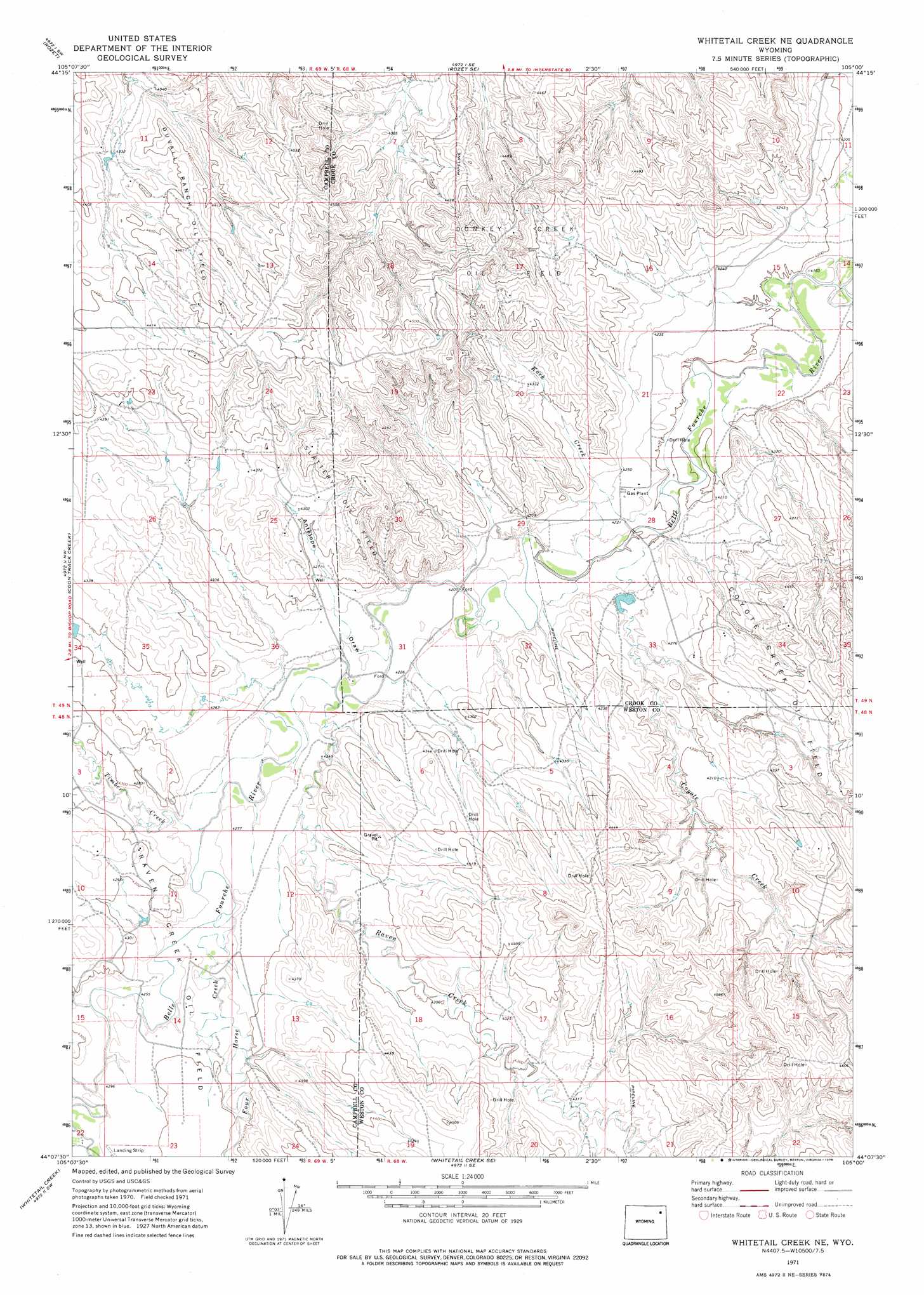
Whitetail Creek Ne Topo Map Wyoming
To zoom in, hover over the map of Whitetail Creek Ne
USGS Topo Quad 44105b1 - 1:24,000 scale
| Topo Map Name: | Whitetail Creek Ne |
| USGS Topo Quad ID: | 44105b1 |
| Print Size: | ca. 21 1/4" wide x 27" high |
| Southeast Coordinates: | 44.125° N latitude / 105° W longitude |
| Map Center Coordinates: | 44.1875° N latitude / 105.0625° W longitude |
| U.S. State: | WY |
| Filename: | o44105b1.jpg |
| Download Map JPG Image: | Whitetail Creek Ne topo map 1:24,000 scale |
| Map Type: | Topographic |
| Topo Series: | 7.5´ |
| Map Scale: | 1:24,000 |
| Source of Map Images: | United States Geological Survey (USGS) |
| Alternate Map Versions: |
Whitetail Creek NE WY 1971, updated 1975 Download PDF Buy paper map Whitetail Creek NE WY 2012 Download PDF Buy paper map Whitetail Creek NE WY 2015 Download PDF Buy paper map |
1:24,000 Topo Quads surrounding Whitetail Creek Ne
Green Hill |
Rozet Nw |
Rozet Ne |
Edith Creek |
Carlile |
Fortin Draw |
Rozet |
Rozet Se |
Moorcroft |
Grasshopper Butte |
Coyote Draw |
Coon Track Creek |
Whitetail Creek Ne |
Spyglass Hill |
Freda Creek |
Saddle Horse Butte |
Whitetail Creek |
Whitetail Creek Se |
Cedar Draw |
Soda Butte |
Neil Butte |
Rough Creek |
Jim Creek |
Raven |
West Fork Buffalo Creek |
> Back to 44105a1 at 1:100,000 scale
> Back to 44104a1 at 1:250,000 scale
> Back to U.S. Topo Maps home
Whitetail Creek Ne topo map: Gazetteer
Whitetail Creek Ne: Dams
Buzzer Dam elevation 1292m 4238′Riveburgh Dam elevation 1338m 4389′
Whitetail Creek Ne: Oilfields
Coyote Creek Oil Field elevation 1338m 4389′Donkey Creek Oil Field elevation 1398m 4586′
Duvall Ranch Oil Field elevation 1354m 4442′
Raven Creek Oil Field elevation 1314m 4311′
Slattery Oil Field elevation 1340m 4396′
Whitetail Creek Ne: Reservoirs
Buzzer Reservoir elevation 1292m 4238′Rivenburgh Reservoir elevation 1338m 4389′
Whitetail Creek Ne: Streams
Coyote Creek elevation 1281m 4202′Four Horse Creek elevation 1300m 4265′
Koch Creek elevation 1278m 4192′
Raven Creek elevation 1287m 4222′
Timber Creek elevation 1293m 4242′
Whitetail Creek Ne: Valleys
Antelope Draw elevation 1292m 4238′Whitetail Creek Ne digital topo map on disk
Buy this Whitetail Creek Ne topo map showing relief, roads, GPS coordinates and other geographical features, as a high-resolution digital map file on DVD:
Eastern Wyoming & Western South Dakota
Buy digital topo maps: Eastern Wyoming & Western South Dakota