Gillette East Topo Map Wyoming
To zoom in, hover over the map of Gillette East
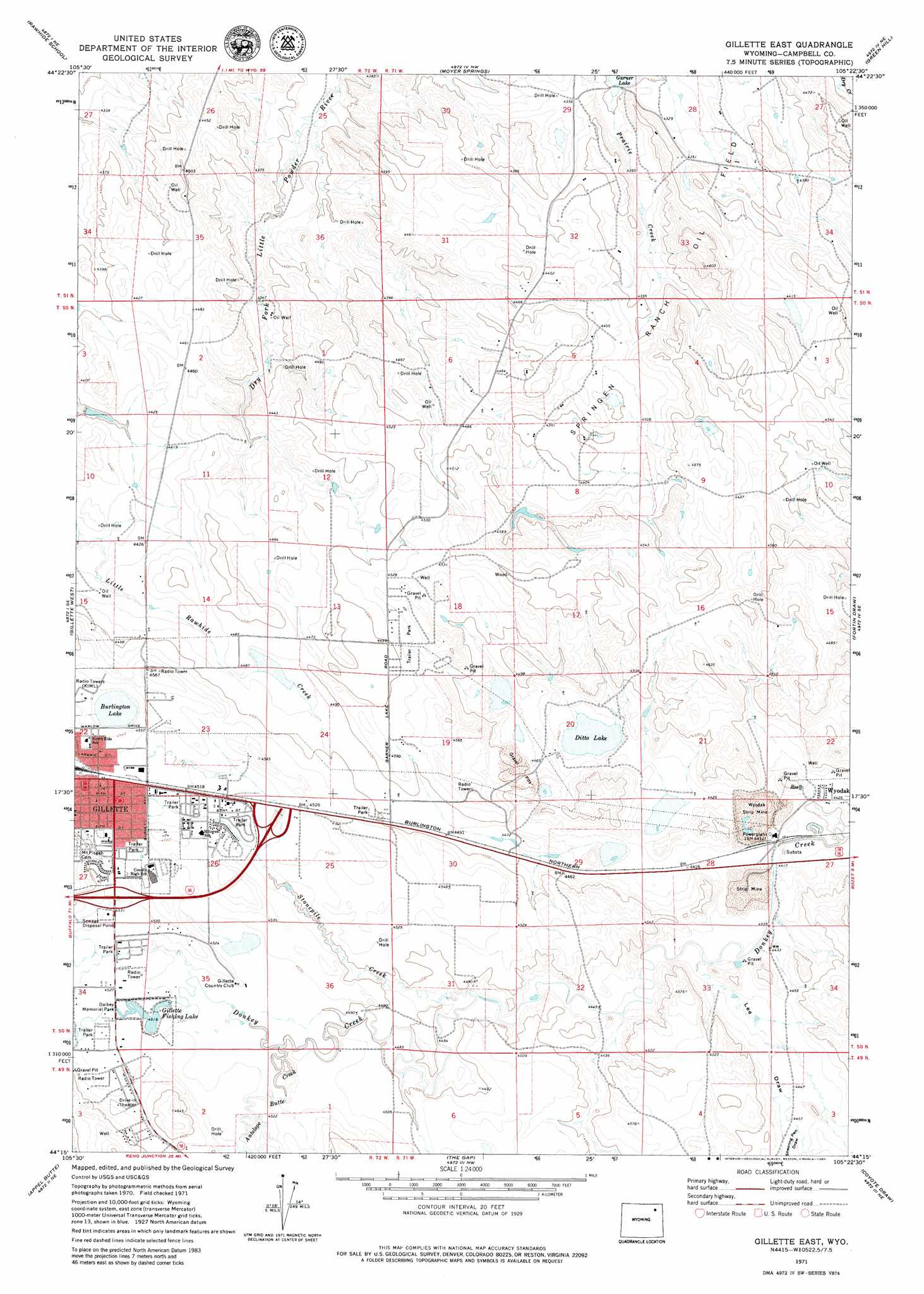
USGS Topo Quad 44105c4 - 1:24,000 scale
| Topo Map Name: | Gillette East |
| USGS Topo Quad ID: | 44105c4 |
| Print Size: | ca. 21 1/4" wide x 27" high |
| Southeast Coordinates: | 44.25° N latitude / 105.375° W longitude |
| Map Center Coordinates: | 44.3125° N latitude / 105.4375° W longitude |
| U.S. State: | WY |
| Filename: | o44105c4.jpg |
| Download Map JPG Image: | Gillette East topo map 1:24,000 scale |
| Map Type: | Topographic |
| Topo Series: | 7.5´ |
| Map Scale: | 1:24,000 |
| Source of Map Images: | United States Geological Survey (USGS) |
| Alternate Map Versions: |
Gillette East WY 1971, updated 1974 Download PDF Buy paper map Gillette East WY 1971, updated 1980 Download PDF Buy paper map Gillette East WY 1971, updated 1980 Download PDF Buy paper map Gillette East WY 2012 Download PDF Buy paper map Gillette East WY 2015 Download PDF Buy paper map |
1:24,000 Topo Quads surrounding Gillette East
Wildcat |
Calf Creek |
Weston Sw |
Lone Tree Creek |
Adon |
Oriva Nw |
Rawhide School |
Moyer Springs |
Green Hill |
Rozet Nw |
Oriva |
Gillette West |
Gillette East |
Fortin Draw |
Rozet |
Four Bar J Ranch |
Appel Butte |
The Gap |
Coyote Draw |
Coon Track Creek |
Pleasantdale |
Scaper Reservoir |
The Gap Sw |
Saddle Horse Butte |
Whitetail Creek |
> Back to 44105a1 at 1:100,000 scale
> Back to 44104a1 at 1:250,000 scale
> Back to U.S. Topo Maps home
Gillette East topo map: Gazetteer
Gillette East: Dams
Gillete Fishing Lake Dam elevation 1379m 4524′Gillette Dam elevation 1385m 4543′
Wyodak Ash Pond Dam elevation 1347m 4419′
Gillette East: Lakes
Burlington Lake elevation 1375m 4511′Ditto Lake elevation 1344m 4409′
Gillette East: Mines
Clovis Point Mine elevation 1384m 4540′Hornet Pit elevation 1378m 4520′
Peerless Mine elevation 1341m 4399′
Wyodak Strip Mine elevation 1324m 4343′
Gillette East: Oilfields
Springen Ranch Oil Field elevation 1341m 4399′Gillette East: Parks
Dalbey Memorial Park elevation 1378m 4520′Gillette East: Populated Places
Collins Heights elevation 1376m 4514′High View Mobile Home Park elevation 1399m 4589′
Sunburst elevation 1390m 4560′
Willamette Mobile Home Park elevation 1411m 4629′
Wyodak elevation 1348m 4422′
Gillette East: Reservoirs
Gillette Fishing Lake elevation 1378m 4520′Gillette Reservoir elevation 1385m 4543′
Wyodak Ash Pond Reservoir elevation 1347m 4419′
Gillette East: Springs
Halsted Spring elevation 1339m 4393′Gillette East: Streams
Antelope Butte Creek elevation 1371m 4498′Stonepile Creek elevation 1360m 4461′
Gillette East: Valleys
Lee Draw elevation 1347m 4419′Shearing Pen Draw elevation 1360m 4461′
Gillette East digital topo map on disk
Buy this Gillette East topo map showing relief, roads, GPS coordinates and other geographical features, as a high-resolution digital map file on DVD:
Eastern Wyoming & Western South Dakota
Buy digital topo maps: Eastern Wyoming & Western South Dakota