Rozet Nw Topo Map Wyoming
To zoom in, hover over the map of Rozet Nw
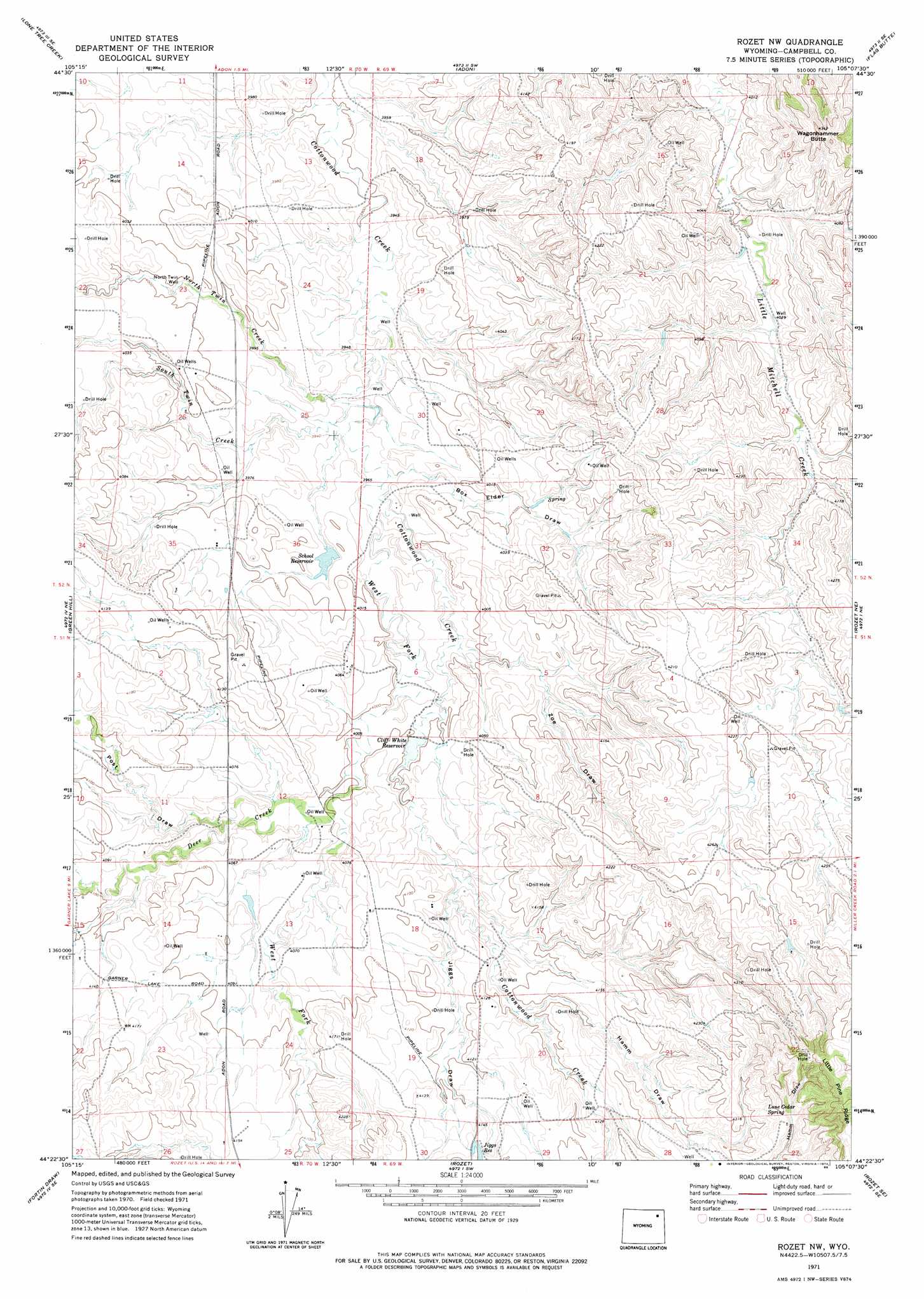
USGS Topo Quad 44105d2 - 1:24,000 scale
| Topo Map Name: | Rozet Nw |
| USGS Topo Quad ID: | 44105d2 |
| Print Size: | ca. 21 1/4" wide x 27" high |
| Southeast Coordinates: | 44.375° N latitude / 105.125° W longitude |
| Map Center Coordinates: | 44.4375° N latitude / 105.1875° W longitude |
| U.S. State: | WY |
| Filename: | o44105d2.jpg |
| Download Map JPG Image: | Rozet Nw topo map 1:24,000 scale |
| Map Type: | Topographic |
| Topo Series: | 7.5´ |
| Map Scale: | 1:24,000 |
| Source of Map Images: | United States Geological Survey (USGS) |
| Alternate Map Versions: |
Rozet NW WY 1971, updated 1974 Download PDF Buy paper map Rozet NW WY 1971, updated 1985 Download PDF Buy paper map Rozet NW WY 2012 Download PDF Buy paper map Rozet NW WY 2015 Download PDF Buy paper map |
1:24,000 Topo Quads surrounding Rozet Nw
Oliver Draw |
Weston |
Adon Nw |
Brislawn School |
Garland Hill |
Weston Sw |
Lone Tree Creek |
Adon |
Flag Butte |
Oshoto |
Moyer Springs |
Green Hill |
Rozet Nw |
Rozet Ne |
Edith Creek |
Gillette East |
Fortin Draw |
Rozet |
Rozet Se |
Moorcroft |
The Gap |
Coyote Draw |
Coon Track Creek |
Whitetail Creek Ne |
Spyglass Hill |
> Back to 44105a1 at 1:100,000 scale
> Back to 44104a1 at 1:250,000 scale
> Back to U.S. Topo Maps home
Rozet Nw topo map: Gazetteer
Rozet Nw: Dams
C White Number 1 Dam elevation 1219m 3999′White Number 2 Dam elevation 1224m 4015′
Rozet Nw: Reservoirs
C White Number 1 Reservoir elevation 1219m 3999′Cliff White Reservoir elevation 1219m 3999′
Jiggs Reservoir elevation 1271m 4169′
School Reservoir elevation 1209m 3966′
White Number 2 Reservoir elevation 1224m 4015′
Rozet Nw: Springs
Lone Cedar Spring elevation 1328m 4356′Rozet Nw: Streams
Deer Creek elevation 1219m 3999′North Twin Creek elevation 1195m 3920′
South Twin Creek elevation 1195m 3920′
West Fork Cottonwood Creek elevation 1200m 3937′
Rozet Nw: Summits
Wagonhammer Butte elevation 1303m 4274′Rozet Nw: Valleys
Box Elder Draw elevation 1207m 3959′Hamm Draw elevation 1242m 4074′
Jiggs Draw elevation 1225m 4019′
Post Draw elevation 1228m 4028′
Zoe Draw elevation 1231m 4038′
Rozet Nw: Wells
North Twin Well elevation 1213m 3979′Rozet Nw digital topo map on disk
Buy this Rozet Nw topo map showing relief, roads, GPS coordinates and other geographical features, as a high-resolution digital map file on DVD:
Eastern Wyoming & Western South Dakota
Buy digital topo maps: Eastern Wyoming & Western South Dakota