Brislawn School Topo Map Wyoming
To zoom in, hover over the map of Brislawn School
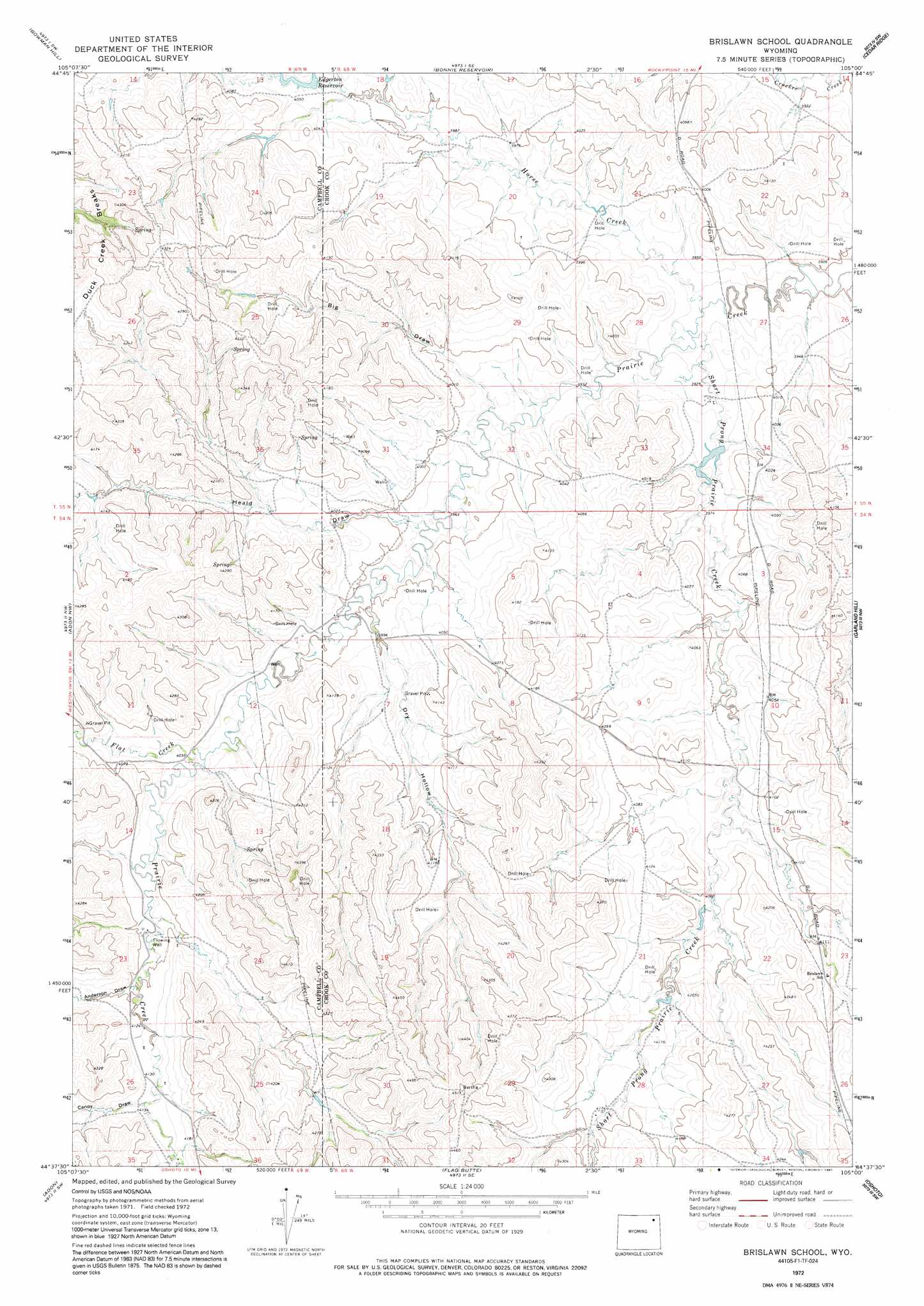
USGS Topo Quad 44105f1 - 1:24,000 scale
| Topo Map Name: | Brislawn School |
| USGS Topo Quad ID: | 44105f1 |
| Print Size: | ca. 21 1/4" wide x 27" high |
| Southeast Coordinates: | 44.625° N latitude / 105° W longitude |
| Map Center Coordinates: | 44.6875° N latitude / 105.0625° W longitude |
| U.S. State: | WY |
| Filename: | o44105f1.jpg |
| Download Map JPG Image: | Brislawn School topo map 1:24,000 scale |
| Map Type: | Topographic |
| Topo Series: | 7.5´ |
| Map Scale: | 1:24,000 |
| Source of Map Images: | United States Geological Survey (USGS) |
| Alternate Map Versions: |
Brislawn School WY 1972, updated 1975 Download PDF Buy paper map Brislawn School WY 1972, updated 1991 Download PDF Buy paper map Brislawn School WY 2012 Download PDF Buy paper map Brislawn School WY 2015 Download PDF Buy paper map |
| FStopo: | US Forest Service topo Brislawn School is available: Download FStopo PDF Download FStopo TIF |
1:24,000 Topo Quads surrounding Brislawn School
Nipple Butte |
Mitten Butte |
Rockypoint |
Moulton Creek |
Storm Draw |
Tuttle Draw |
Bowman Hill |
Bonnie Reservoir |
Cedar Ridge |
Wood Canyon |
Weston |
Adon Nw |
Brislawn School |
Garland Hill |
New Haven |
Lone Tree Creek |
Adon |
Flag Butte |
Oshoto |
Missouri Buttes |
Green Hill |
Rozet Nw |
Rozet Ne |
Edith Creek |
Carlile |
> Back to 44105e1 at 1:100,000 scale
> Back to 44104a1 at 1:250,000 scale
> Back to U.S. Topo Maps home
Brislawn School topo map: Gazetteer
Brislawn School: Dams
Baker Number 1 Dam elevation 1197m 3927′Edgerton Dam elevation 1238m 4061′
Brislawn School: Reservoirs
Baker Number 1 Reservoir elevation 1197m 3927′Edgerton Reservoir elevation 1238m 4061′
Edgerton Reservoir elevation 1231m 4038′
Brislawn School: Streams
Flat Creek elevation 1231m 4038′Horse Creek elevation 1193m 3914′
Short Prong Prairie Creek elevation 1193m 3914′
Brislawn School: Valleys
Anderson Draw elevation 1250m 4101′Big Draw elevation 1213m 3979′
Canoy Draw elevation 1257m 4124′
Dry Hollow elevation 1217m 3992′
Heald Draw elevation 1218m 3996′
Brislawn School digital topo map on disk
Buy this Brislawn School topo map showing relief, roads, GPS coordinates and other geographical features, as a high-resolution digital map file on DVD:
Eastern Wyoming & Western South Dakota
Buy digital topo maps: Eastern Wyoming & Western South Dakota