Rocky Butte Topo Map Wyoming
To zoom in, hover over the map of Rocky Butte
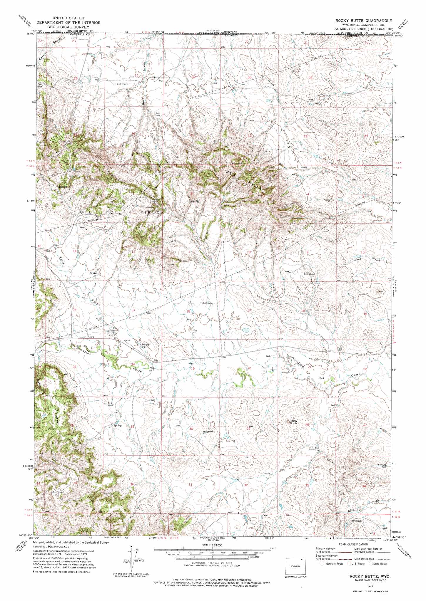
USGS Topo Quad 44105h4 - 1:24,000 scale
| Topo Map Name: | Rocky Butte |
| USGS Topo Quad ID: | 44105h4 |
| Print Size: | ca. 21 1/4" wide x 27" high |
| Southeast Coordinates: | 44.875° N latitude / 105.375° W longitude |
| Map Center Coordinates: | 44.9375° N latitude / 105.4375° W longitude |
| U.S. State: | WY |
| Filename: | o44105h4.jpg |
| Download Map JPG Image: | Rocky Butte topo map 1:24,000 scale |
| Map Type: | Topographic |
| Topo Series: | 7.5´ |
| Map Scale: | 1:24,000 |
| Source of Map Images: | United States Geological Survey (USGS) |
| Alternate Map Versions: |
Rocky Butte WY 1972, updated 1975 Download PDF Buy paper map Rocky Butte WY 2011 Download PDF Buy paper map Rocky Butte WY 2012 Download PDF Buy paper map Rocky Butte WY 2015 Download PDF Buy paper map |
1:24,000 Topo Quads surrounding Rocky Butte
Huckins School |
Baldy Peak |
Bear Skull Mountain |
Pine Creek |
Sanburn Reservoir |
Three Bar Ranch |
Bay Horse |
Wild Bill Creek |
Biddle |
Belle Creek Sw |
Corral Creek |
Homestead Draw |
Rocky Butte |
Nipple Butte |
Mitten Butte |
Homestead Draw Sw |
White Tail Butte |
Rocky Butte Sw |
Tuttle Draw |
Bowman Hill |
Recluse |
Pitch Draw |
Oliver Draw |
Weston |
Adon Nw |
> Back to 44105e1 at 1:100,000 scale
> Back to 44104a1 at 1:250,000 scale
> Back to U.S. Topo Maps home
Rocky Butte topo map: Gazetteer
Rocky Butte: Oilfields
Ute Oil Field elevation 1165m 3822′Rocky Butte: Ranges
Red Hills elevation 1311m 4301′Rocky Butte: Streams
North Fork Olmstead Creek elevation 1092m 3582′Rocky Butte: Summits
Rocky Butte elevation 1139m 3736′Rocky Butte: Valleys
Daley Draw elevation 1110m 3641′Rocky Butte digital topo map on disk
Buy this Rocky Butte topo map showing relief, roads, GPS coordinates and other geographical features, as a high-resolution digital map file on DVD:
Eastern Wyoming & Western South Dakota
Buy digital topo maps: Eastern Wyoming & Western South Dakota