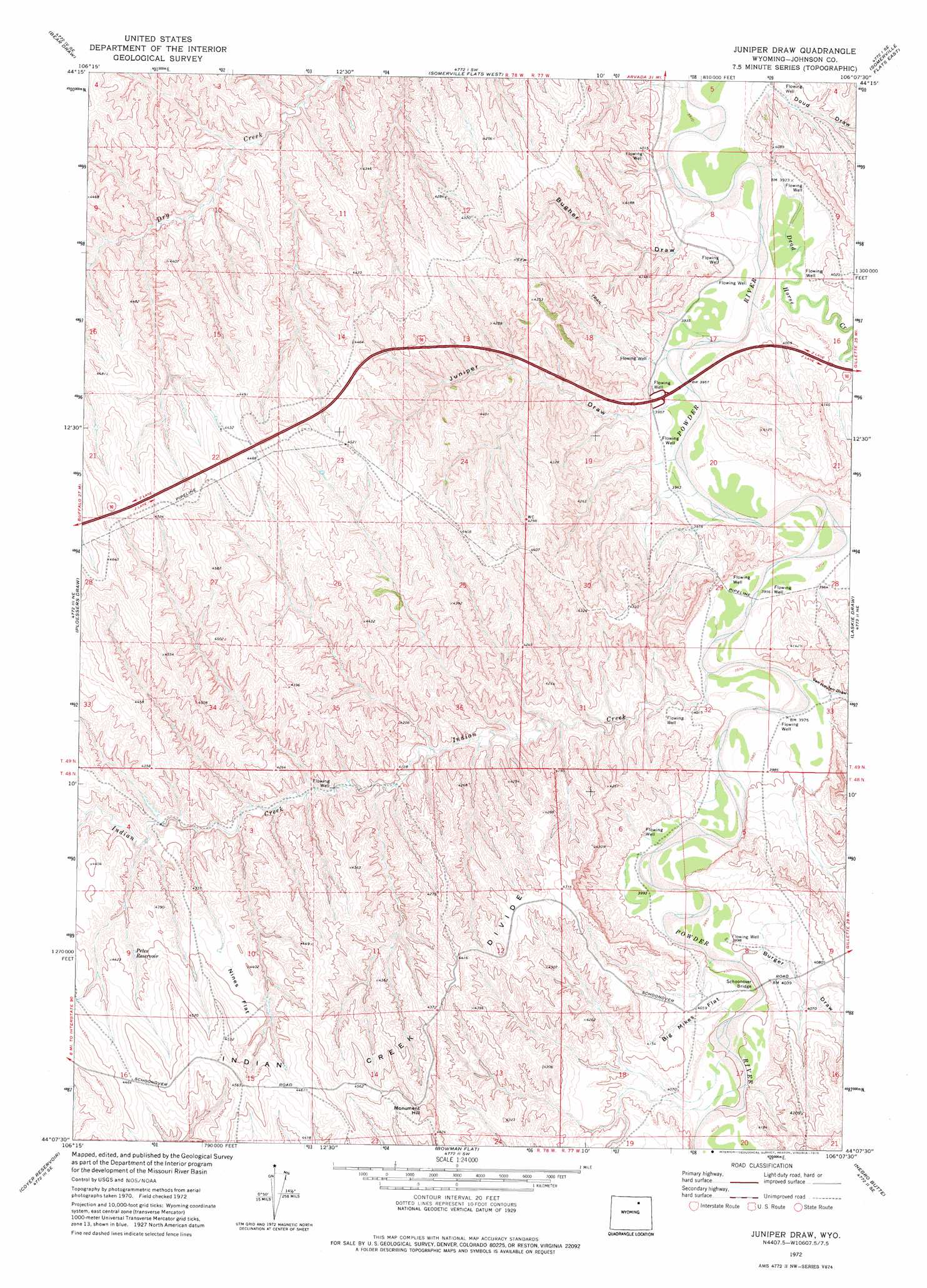
Juniper Draw Topo Map Wyoming
To zoom in, hover over the map of Juniper Draw
USGS Topo Quad 44106b2 - 1:24,000 scale
| Topo Map Name: | Juniper Draw |
| USGS Topo Quad ID: | 44106b2 |
| Print Size: | ca. 21 1/4" wide x 27" high |
| Southeast Coordinates: | 44.125° N latitude / 106.125° W longitude |
| Map Center Coordinates: | 44.1875° N latitude / 106.1875° W longitude |
| U.S. State: | WY |
| Filename: | o44106b2.jpg |
| Download Map JPG Image: | Juniper Draw topo map 1:24,000 scale |
| Map Type: | Topographic |
| Topo Series: | 7.5´ |
| Map Scale: | 1:24,000 |
| Source of Map Images: | United States Geological Survey (USGS) |
| Alternate Map Versions: |
Juniper Draw WY 1972, updated 1975 Download PDF Buy paper map Juniper Draw WY 2012 Download PDF Buy paper map Juniper Draw WY 2015 Download PDF Buy paper map |
1:24,000 Topo Quads surrounding Juniper Draw
Fredrick Draw |
Floate Draw |
Mitchell Draw |
Livingston Draw |
Echeta |
Pine Gulch |
Bear Draw |
Somerville Flats West |
Somerville Flats East |
Carr Draw |
Crazy Woman Ranch |
Ploessers Draw |
Juniper Draw |
Laskie Draw |
Morgan Draw |
Brown Ranch |
Boon |
Bowman Flat |
Negro Butte |
Bogie Draw |
Elaine Draw |
Provence Ranch |
Hoe Ranch |
The Nipple |
Fats Draw |
> Back to 44106a1 at 1:100,000 scale
> Back to 44106a1 at 1:250,000 scale
> Back to U.S. Topo Maps home
Juniper Draw topo map: Gazetteer
Juniper Draw: Bridges
Schoonover Bridge elevation 1218m 3996′Juniper Draw: Flats
Big Mikes Flat elevation 1239m 4064′Nines Flat elevation 1341m 4399′
Juniper Draw: Mines
Marton Powder River Pit elevation 1219m 3999′Juniper Draw: Reservoirs
Petes Reservoir elevation 1322m 4337′Juniper Draw: Streams
Dead Horse Creek elevation 1201m 3940′Indian Creek elevation 1207m 3959′
Juniper Draw: Summits
Monument Hill elevation 1397m 4583′Juniper Draw: Valleys
Bugher Draw elevation 1208m 3963′Burger Draw elevation 1218m 3996′
Doud Draw elevation 1201m 3940′
Juniper Draw elevation 1207m 3959′
Van Houten Draw elevation 1213m 3979′
Juniper Draw digital topo map on disk
Buy this Juniper Draw topo map showing relief, roads, GPS coordinates and other geographical features, as a high-resolution digital map file on DVD:
Eastern Wyoming & Western South Dakota
Buy digital topo maps: Eastern Wyoming & Western South Dakota