Big Horn Topo Map Wyoming
To zoom in, hover over the map of Big Horn
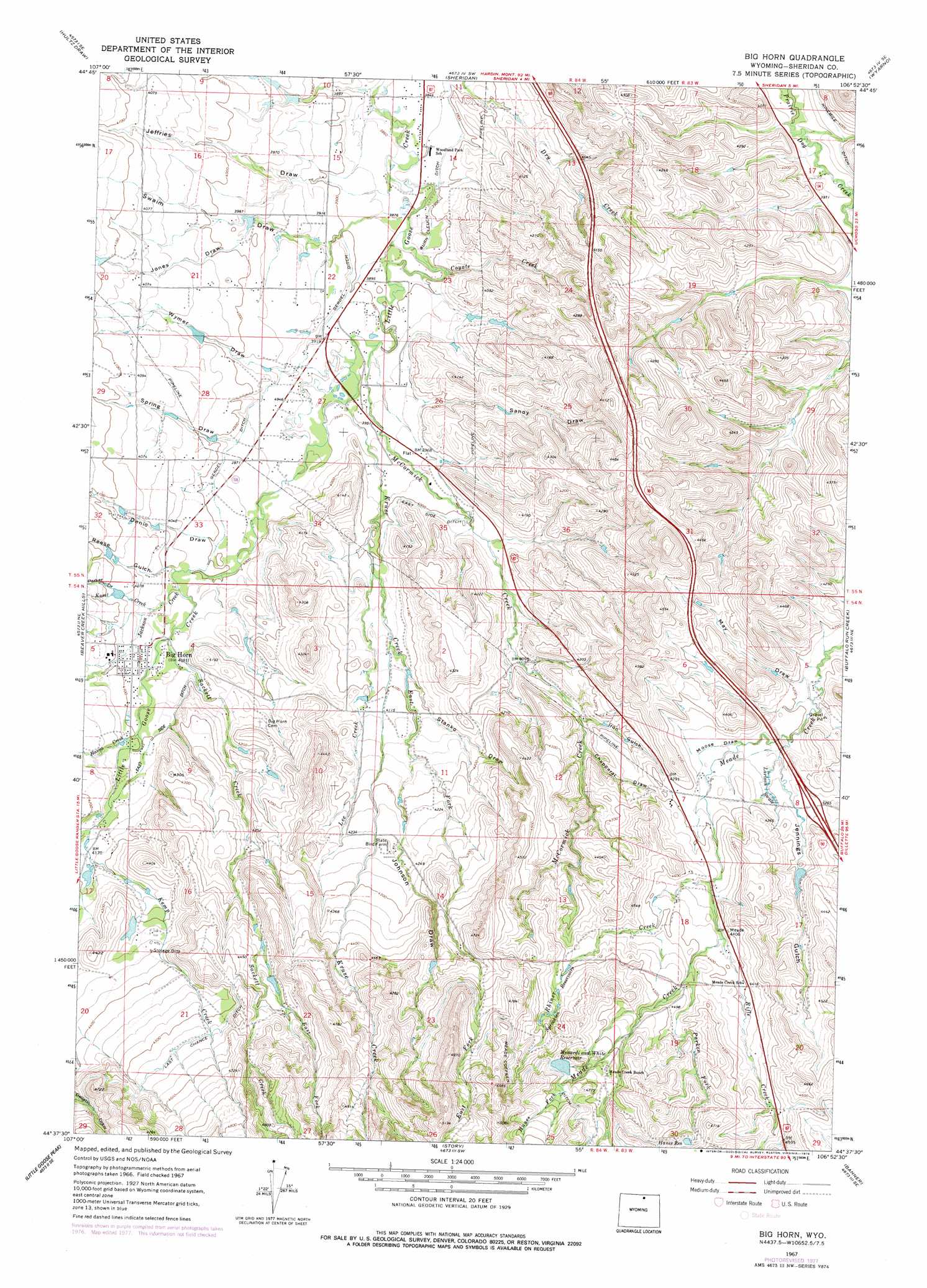
USGS Topo Quad 44106f8 - 1:24,000 scale
| Topo Map Name: | Big Horn |
| USGS Topo Quad ID: | 44106f8 |
| Print Size: | ca. 21 1/4" wide x 27" high |
| Southeast Coordinates: | 44.625° N latitude / 106.875° W longitude |
| Map Center Coordinates: | 44.6875° N latitude / 106.9375° W longitude |
| U.S. State: | WY |
| Filename: | o44106f8.jpg |
| Download Map JPG Image: | Big Horn topo map 1:24,000 scale |
| Map Type: | Topographic |
| Topo Series: | 7.5´ |
| Map Scale: | 1:24,000 |
| Source of Map Images: | United States Geological Survey (USGS) |
| Alternate Map Versions: |
Big Horn WY 1967, updated 1972 Download PDF Buy paper map Big Horn WY 1967, updated 1978 Download PDF Buy paper map Big Horn WY 1967, updated 1978 Download PDF Buy paper map Big Horn WY 2012 Download PDF Buy paper map Big Horn WY 2015 Download PDF Buy paper map |
1:24,000 Topo Quads surrounding Big Horn
Ranchester |
Monarch |
Acme |
Bar N Draw |
Cedar Canyon |
Wolf |
Hultz Draw |
Sheridan |
Wyarno |
Jones Draw |
Beckton |
Beaver Creek Hills |
Big Horn |
Buffalo Run Creek |
Verona |
Park Reservoir |
Little Goose Peak |
Story |
Banner |
Horse Hill |
Cloud Peak |
Willow Park Reservoir |
Stone Mountain |
Lake De Smet West |
Lake De Smet East |
> Back to 44106e1 at 1:100,000 scale
> Back to 44106a1 at 1:250,000 scale
> Back to U.S. Topo Maps home
Big Horn topo map: Gazetteer
Big Horn: Canals
East Side Ditch elevation 1226m 4022′Gerdel Ditch elevation 1194m 3917′
Last Chance Ditch elevation 1386m 4547′
Big Horn: Dams
Allen Dam elevation 1363m 4471′Duncan Dam elevation 1319m 4327′
Menardi and White Dam elevation 1417m 4648′
Big Horn: Populated Places
Big Horn elevation 1238m 4061′Big Horn: Reservoirs
Allen Reservoir elevation 1363m 4471′Duncan Reservoir elevation 1319m 4327′
Hanes Reservoir elevation 1415m 4642′
Menardi and White Reservoir elevation 1417m 4648′
Menardi and White Reservoir elevation 1437m 4714′
Big Horn: Streams
Coyote Creek elevation 1184m 3884′East Fork Kruse Creek elevation 1237m 4058′
East Fork Sackett Creek elevation 1347m 4419′
Hanes Fork elevation 1451m 4760′
Hanna Creek elevation 1250m 4101′
Jackson Creek elevation 1226m 4022′
Kemp Creek elevation 1266m 4153′
Kruse Creek elevation 1196m 3923′
Kusel Creek elevation 1232m 4041′
Lee Creek elevation 1226m 4022′
McCormick Creek elevation 1190m 3904′
Parken Fork elevation 1345m 4412′
Rifle Creek elevation 1335m 4379′
Sackett Creek elevation 1232m 4041′
Big Horn: Swamps
Larison Swale elevation 1293m 4242′Big Horn: Valleys
Chapparal Draw elevation 1268m 4160′Denio Draw elevation 1220m 4002′
Iron Gulch elevation 1262m 4140′
Jeffries Draw elevation 1189m 3900′
Jennings Gulch elevation 1287m 4222′
Johnson Draw elevation 1265m 4150′
Jones Draw elevation 1213m 3979′
May Draw elevation 1278m 4192′
Moose Draw elevation 1287m 4222′
Parker Draw elevation 1247m 4091′
Reese Gulch elevation 1226m 4022′
Sandy Draw elevation 1214m 3982′
Spring Draw elevation 1214m 3982′
Stanko Draw elevation 1244m 4081′
Swaim Draw elevation 1189m 3900′
Wymer Draw elevation 1202m 3943′
Big Horn digital topo map on disk
Buy this Big Horn topo map showing relief, roads, GPS coordinates and other geographical features, as a high-resolution digital map file on DVD:
Eastern Wyoming & Western South Dakota
Buy digital topo maps: Eastern Wyoming & Western South Dakota