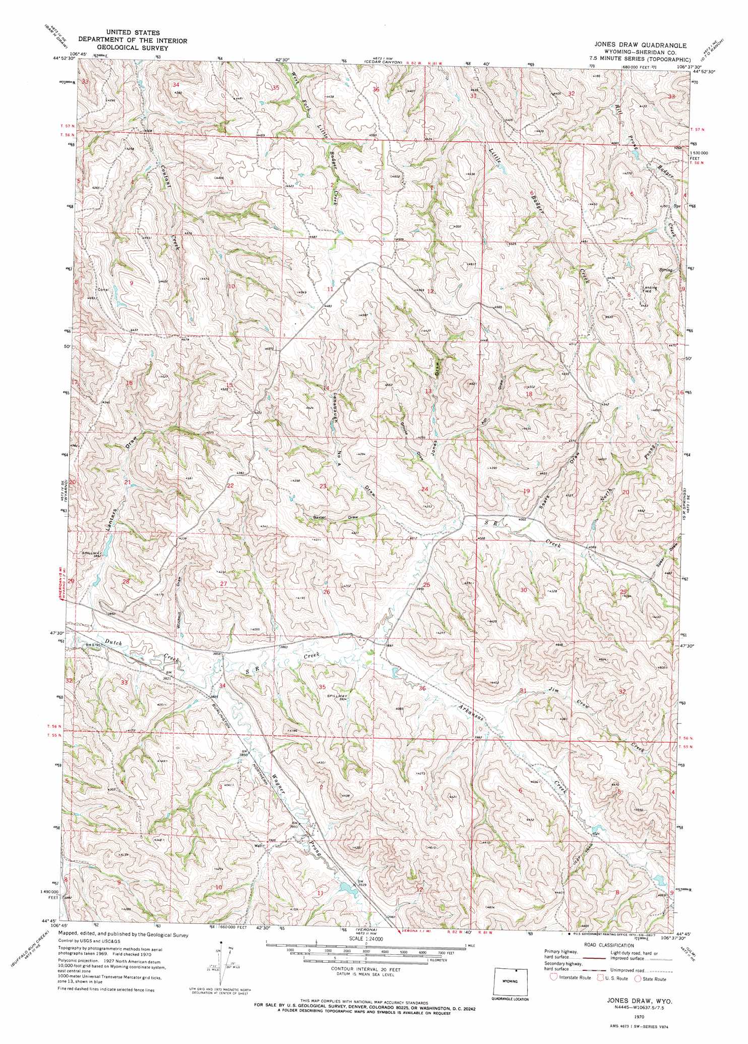
Jones Draw Topo Map Wyoming
To zoom in, hover over the map of Jones Draw
USGS Topo Quad 44106g6 - 1:24,000 scale
| Topo Map Name: | Jones Draw |
| USGS Topo Quad ID: | 44106g6 |
| Print Size: | ca. 21 1/4" wide x 27" high |
| Southeast Coordinates: | 44.75° N latitude / 106.625° W longitude |
| Map Center Coordinates: | 44.8125° N latitude / 106.6875° W longitude |
| U.S. State: | WY |
| Filename: | o44106g6.jpg |
| Download Map JPG Image: | Jones Draw topo map 1:24,000 scale |
| Map Type: | Topographic |
| Topo Series: | 7.5´ |
| Map Scale: | 1:24,000 |
| Source of Map Images: | United States Geological Survey (USGS) |
| Alternate Map Versions: |
Jones Draw WY 1970, updated 1973 Download PDF Buy paper map Jones Draw WY 2012 Download PDF Buy paper map Jones Draw WY 2015 Download PDF Buy paper map |
1:24,000 Topo Quads surrounding Jones Draw
Pearl School |
Decker |
Holmes Ranch |
Pine Butte School |
Forks Ranch |
Acme |
Bar N Draw |
Cedar Canyon |
O T O Ranch |
Roundup Draw |
Sheridan |
Wyarno |
Jones Draw |
S R Springs |
Shuler Draw |
Big Horn |
Buffalo Run Creek |
Verona |
Ulm |
Clearmont |
Story |
Banner |
Horse Hill |
Ucross |
Julio Draw |
> Back to 44106e1 at 1:100,000 scale
> Back to 44106a1 at 1:250,000 scale
> Back to U.S. Topo Maps home
Jones Draw topo map: Gazetteer
Jones Draw: Dams
Dodd Dam elevation 1214m 3982′Jones Draw: Reservoirs
Dodd Reservoir elevation 1214m 3982′Jones Draw: Streams
Arkansas Creek elevation 1186m 3891′Jim Crow Creek elevation 1207m 3959′
North Prong S R Creek elevation 1240m 4068′
S R Creek elevation 1166m 3825′
Wagner Prong Dutch Creek elevation 1166m 3825′
Jones Draw: Valleys
Ash Draw elevation 1241m 4071′Baxter Draw elevation 1228m 4028′
Grouse Draw elevation 1241m 4071′
Jones Draw elevation 1217m 3992′
Lanbaugh Number 4 Draw elevation 1210m 3969′
Lanters Draw elevation 1166m 3825′
Sears Draw elevation 1232m 4041′
Spear Draw elevation 1260m 4133′
Windmill Draw elevation 1180m 3871′
Jones Draw digital topo map on disk
Buy this Jones Draw topo map showing relief, roads, GPS coordinates and other geographical features, as a high-resolution digital map file on DVD:
Eastern Wyoming & Western South Dakota
Buy digital topo maps: Eastern Wyoming & Western South Dakota