Bar N Draw Topo Map Wyoming
To zoom in, hover over the map of Bar N Draw
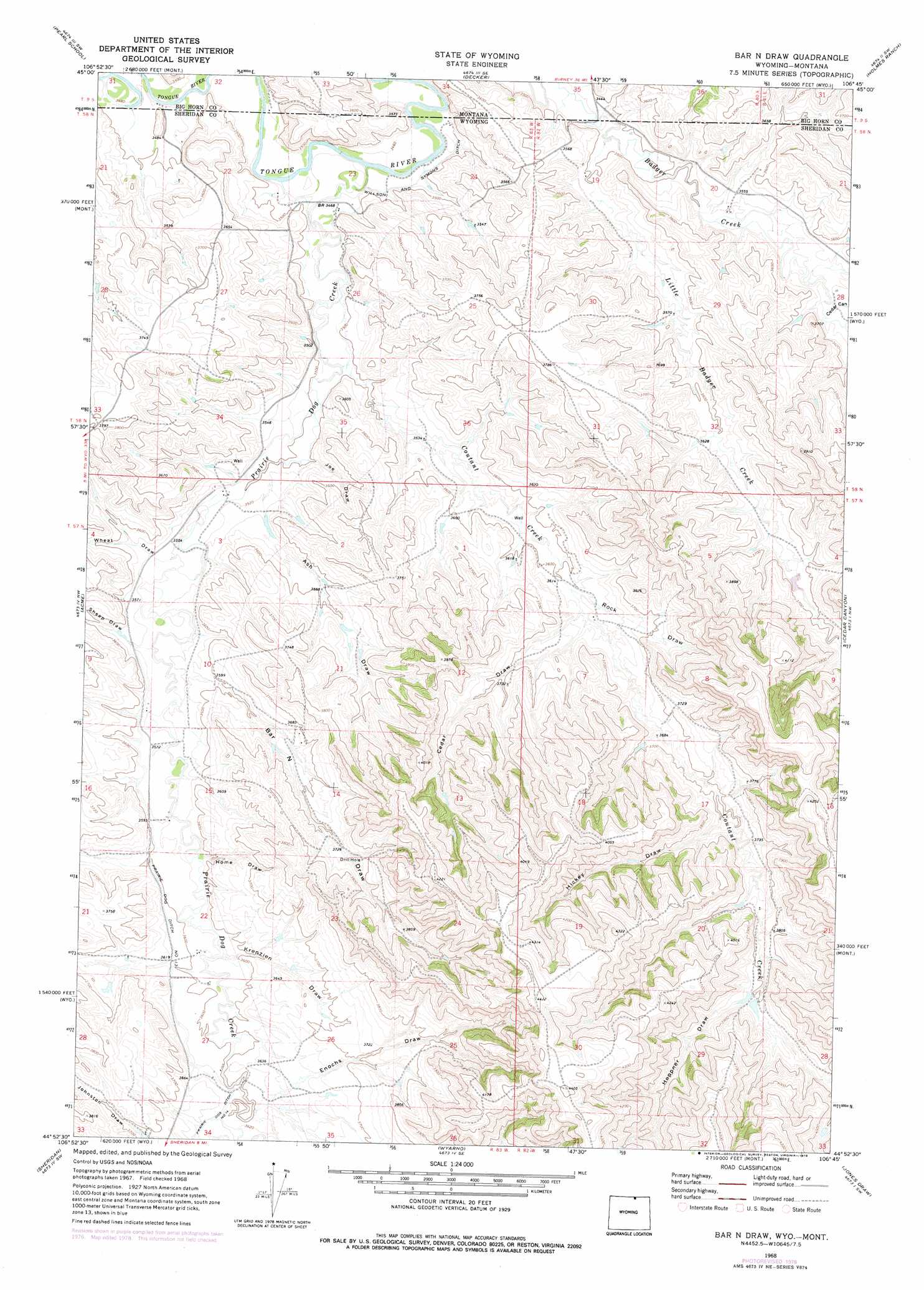
USGS Topo Quad 44106h7 - 1:24,000 scale
| Topo Map Name: | Bar N Draw |
| USGS Topo Quad ID: | 44106h7 |
| Print Size: | ca. 21 1/4" wide x 27" high |
| Southeast Coordinates: | 44.875° N latitude / 106.75° W longitude |
| Map Center Coordinates: | 44.9375° N latitude / 106.8125° W longitude |
| U.S. States: | WY, MT |
| Filename: | o44106h7.jpg |
| Download Map JPG Image: | Bar N Draw topo map 1:24,000 scale |
| Map Type: | Topographic |
| Topo Series: | 7.5´ |
| Map Scale: | 1:24,000 |
| Source of Map Images: | United States Geological Survey (USGS) |
| Alternate Map Versions: |
Bar N Draw WY 1968, updated 1972 Download PDF Buy paper map Bar N Draw WY 1968, updated 1978 Download PDF Buy paper map Bar N Draw WY 2011 Download PDF Buy paper map Bar N Draw WY 2012 Download PDF Buy paper map Bar N Draw WY 2015 Download PDF Buy paper map |
1:24,000 Topo Quads surrounding Bar N Draw
Bar V Ranch Ne |
Half Moon Hill |
Tongue River Dam |
Spring Gulch |
Lacey Gulch |
Bar V Ranch |
Pearl School |
Decker |
Holmes Ranch |
Pine Butte School |
Monarch |
Acme |
Bar N Draw |
Cedar Canyon |
O T O Ranch |
Hultz Draw |
Sheridan |
Wyarno |
Jones Draw |
S R Springs |
Beaver Creek Hills |
Big Horn |
Buffalo Run Creek |
Verona |
Ulm |
> Back to 44106e1 at 1:100,000 scale
> Back to 44106a1 at 1:250,000 scale
> Back to U.S. Topo Maps home
Bar N Draw topo map: Gazetteer
Bar N Draw: Canals
Prairie Dog Ditch Number 13 elevation 1101m 3612′Prairie Dog Ditch Number 14 elevation 1107m 3631′
Bar N Draw: Dams
Gorman Number 2 Dam elevation 1116m 3661′Bar N Draw: Mines
Badger Creek Mine elevation 1095m 3592′Carneyville Mine elevation 1171m 3841′
Evans Mine elevation 1095m 3592′
Bar N Draw: Reservoirs
Gorman Reservoir Number 2 elevation 1116m 3661′Bar N Draw: Streams
Coutant Creek elevation 1058m 3471′Little Badger Creek elevation 1055m 3461′
Prairie Dog Creek elevation 1048m 3438′
Bar N Draw: Valleys
Ash Draw elevation 1073m 3520′Bar N Draw elevation 1092m 3582′
Cedar Canyon elevation 1080m 3543′
Cedar Draw elevation 1104m 3622′
Enochs Draw elevation 1101m 3612′
Heppner Draw elevation 1156m 3792′
Hickey Draw elevation 1124m 3687′
Home Draw elevation 1092m 3582′
Joe Draw elevation 1070m 3510′
Krenzien Draw elevation 1092m 3582′
Rock Draw elevation 1097m 3599′
Sheep Draw elevation 1085m 3559′
Wheat Draw elevation 1077m 3533′
Bar N Draw digital topo map on disk
Buy this Bar N Draw topo map showing relief, roads, GPS coordinates and other geographical features, as a high-resolution digital map file on DVD:
Eastern Wyoming & Western South Dakota
Buy digital topo maps: Eastern Wyoming & Western South Dakota