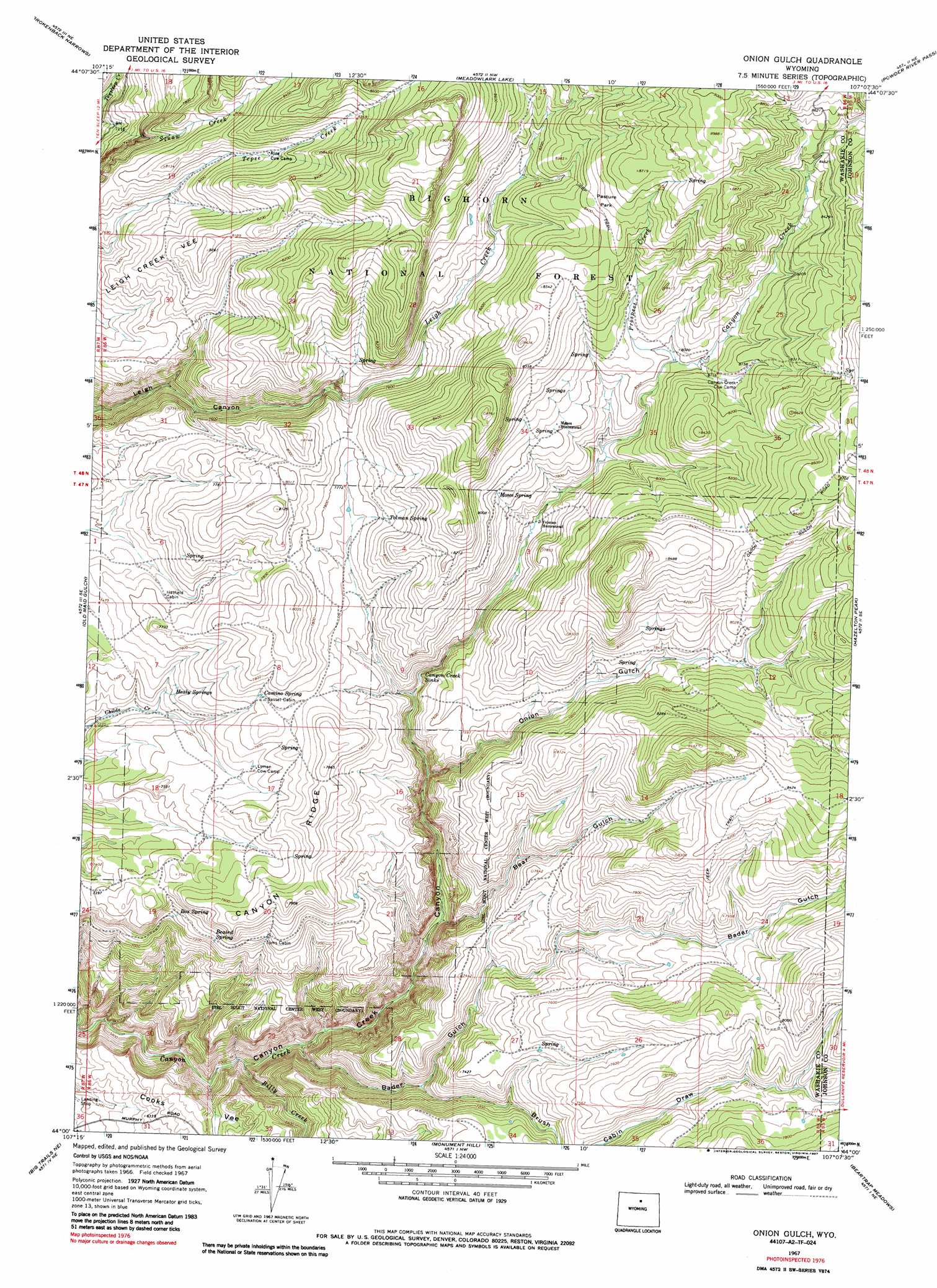
Onion Gulch Topo Map Wyoming
To zoom in, hover over the map of Onion Gulch
USGS Topo Quad 44107a2 - 1:24,000 scale
| Topo Map Name: | Onion Gulch |
| USGS Topo Quad ID: | 44107a2 |
| Print Size: | ca. 21 1/4" wide x 27" high |
| Southeast Coordinates: | 44° N latitude / 107.125° W longitude |
| Map Center Coordinates: | 44.0625° N latitude / 107.1875° W longitude |
| U.S. State: | WY |
| Filename: | o44107a2.jpg |
| Download Map JPG Image: | Onion Gulch topo map 1:24,000 scale |
| Map Type: | Topographic |
| Topo Series: | 7.5´ |
| Map Scale: | 1:24,000 |
| Source of Map Images: | United States Geological Survey (USGS) |
| Alternate Map Versions: |
Onion Gulch WY 1967, updated 1970 Download PDF Buy paper map Onion Gulch WY 1967, updated 1987 Download PDF Buy paper map Onion Gulch WY 1993, updated 1997 Download PDF Buy paper map Onion Gulch WY 2012 Download PDF Buy paper map Onion Gulch WY 2015 Download PDF Buy paper map |
| FStopo: | US Forest Service topo Onion Gulch is available: Download FStopo PDF Download FStopo TIF |
1:24,000 Topo Quads surrounding Onion Gulch
Allen Draw |
Lake Solitude |
Lake Helen |
Lake Angeline |
Hunter Mesa |
Pierce Draw |
Brokenback Narrows |
Meadowlark Lake |
Powder River Pass |
Caribou Creek |
Ten Sleep |
Old Maid Gulch |
Onion Gulch |
Hazelton Peak |
Hazelton |
Joe Emge Creek |
Big Trails Ne |
Monument Hill |
Beartrap Meadows |
Packsaddle Canyon |
Indian Creek |
Big Trails |
Tallon Spring |
Tabletop |
Fraker Mountain |
> Back to 44107a1 at 1:100,000 scale
> Back to 44106a1 at 1:250,000 scale
> Back to U.S. Topo Maps home
Onion Gulch topo map: Gazetteer
Onion Gulch: Basins
Canyon Creek Sinks elevation 2261m 7417′Onion Gulch: Flats
Pasture Park elevation 2596m 8517′Onion Gulch: Mines
Canyon Creek Claim Mine elevation 2523m 8277′Canyon Creek Mine elevation 2515m 8251′
Canyon Creek Talc Mine elevation 2525m 8284′
Onion Gulch: Springs
Beaird Spring elevation 2235m 7332′Box Spring elevation 2217m 7273′
Camino Spring elevation 2339m 7673′
Healy Springs elevation 2266m 7434′
Moses Spring elevation 2406m 7893′
Tolman Spring elevation 2393m 7851′
Onion Gulch: Streams
Billy Creek elevation 1823m 5980′Prospect Creek elevation 2426m 7959′
Onion Gulch: Valleys
Bader Gulch elevation 1886m 6187′Bear Gulch elevation 2037m 6683′
Brush Cabin Draw elevation 2089m 6853′
Onion Gulch elevation 2419m 7936′
Onion Gulch digital topo map on disk
Buy this Onion Gulch topo map showing relief, roads, GPS coordinates and other geographical features, as a high-resolution digital map file on DVD:
Eastern Wyoming & Western South Dakota
Buy digital topo maps: Eastern Wyoming & Western South Dakota