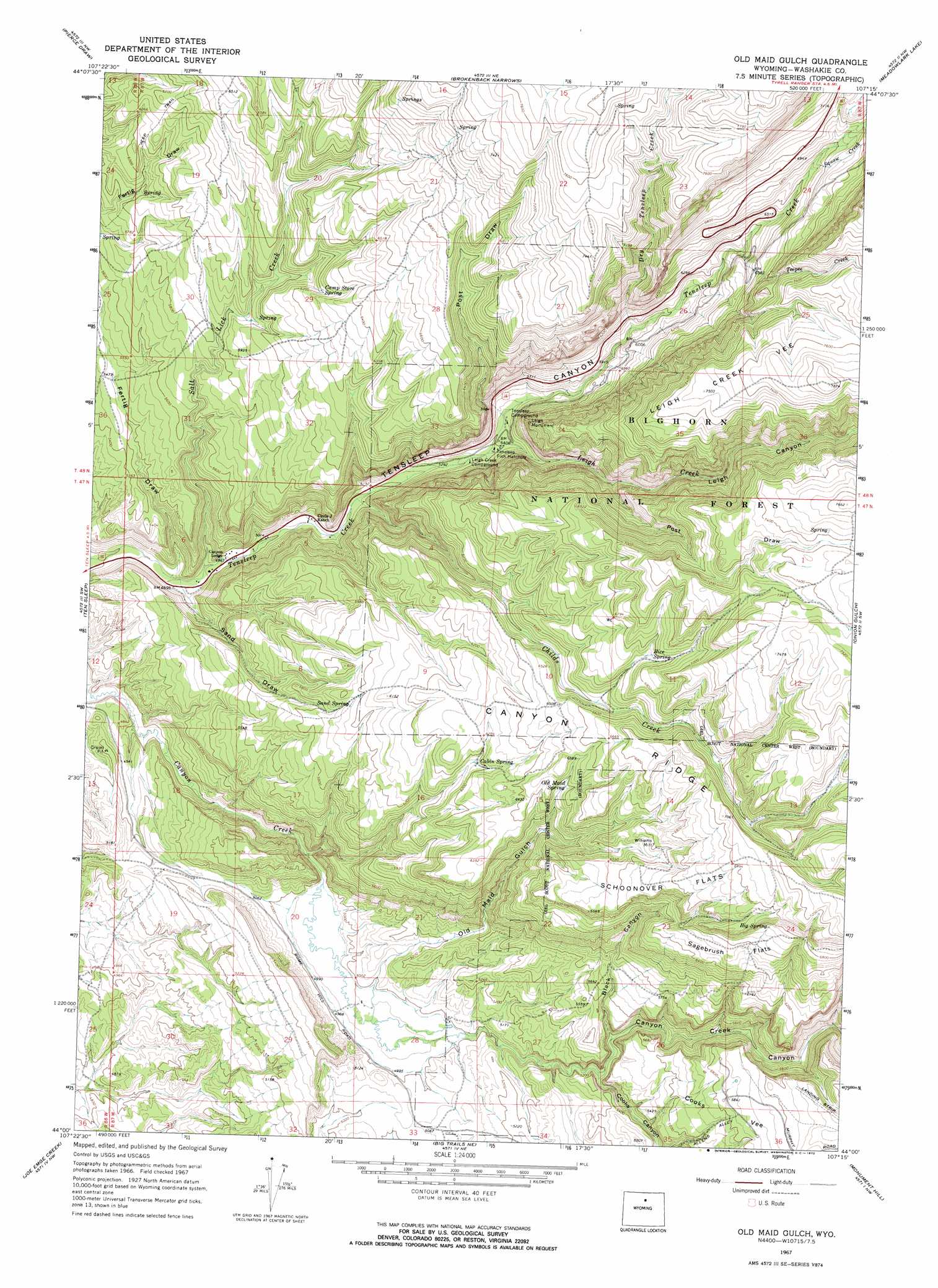
Old Maid Gulch Topo Map Wyoming
To zoom in, hover over the map of Old Maid Gulch
USGS Topo Quad 44107a3 - 1:24,000 scale
| Topo Map Name: | Old Maid Gulch |
| USGS Topo Quad ID: | 44107a3 |
| Print Size: | ca. 21 1/4" wide x 27" high |
| Southeast Coordinates: | 44° N latitude / 107.25° W longitude |
| Map Center Coordinates: | 44.0625° N latitude / 107.3125° W longitude |
| U.S. State: | WY |
| Filename: | o44107a3.jpg |
| Download Map JPG Image: | Old Maid Gulch topo map 1:24,000 scale |
| Map Type: | Topographic |
| Topo Series: | 7.5´ |
| Map Scale: | 1:24,000 |
| Source of Map Images: | United States Geological Survey (USGS) |
| Alternate Map Versions: |
Old Maid Gulch WY 1967, updated 1970 Download PDF Buy paper map Old Maid Gulch WY 1993, updated 1997 Download PDF Buy paper map Old Maid Gulch WY 2012 Download PDF Buy paper map Old Maid Gulch WY 2015 Download PDF Buy paper map |
| FStopo: | US Forest Service topo Old Maid Gulch is available: Download FStopo PDF Download FStopo TIF |
1:24,000 Topo Quads surrounding Old Maid Gulch
Hyatt Ranch |
Allen Draw |
Lake Solitude |
Lake Helen |
Lake Angeline |
Hyattville |
Pierce Draw |
Brokenback Narrows |
Meadowlark Lake |
Powder River Pass |
Wild Horse Hill |
Ten Sleep |
Old Maid Gulch |
Onion Gulch |
Hazelton Peak |
Castle Gardens |
Joe Emge Creek |
Big Trails Ne |
Monument Hill |
Beartrap Meadows |
Deadline Draw |
Indian Creek |
Big Trails |
Tallon Spring |
Tabletop |
> Back to 44107a1 at 1:100,000 scale
> Back to 44106a1 at 1:250,000 scale
> Back to U.S. Topo Maps home
Old Maid Gulch topo map: Gazetteer
Old Maid Gulch: Flats
Leigh Creek Vee elevation 2321m 7614′Sagebrush Flats elevation 1994m 6541′
Schoonover Flats elevation 2071m 6794′
Old Maid Gulch: Mines
Daugherty Pit elevation 1555m 5101′Davis Number One Pit elevation 1535m 5036′
Tensleep Canyon Mine elevation 1915m 6282′
Tomis Pit elevation 1608m 5275′
Old Maid Gulch: Pillars
Leigh Monument elevation 1945m 6381′Old Maid Gulch: Ridges
Canyon Ridge elevation 2034m 6673′Old Maid Gulch: Springs
Big Spring elevation 2048m 6719′Cabin Spring elevation 1884m 6181′
Camp Stove Spring elevation 1894m 6213′
Old Maid Spring elevation 1941m 6368′
Rice Spring elevation 2056m 6745′
Sand Spring elevation 1815m 5954′
Old Maid Gulch: Streams
Childs Creek elevation 1568m 5144′Dry Tensleep Creek elevation 1806m 5925′
Leigh Creek elevation 1637m 5370′
Salt Lick Creek elevation 1500m 4921′
Squaw Creek elevation 2030m 6660′
Tepee Creek elevation 1921m 6302′
Old Maid Gulch: Valleys
Black Canyon elevation 1595m 5232′Canyon Creek Canyon elevation 1546m 5072′
Cooks Canyon elevation 1563m 5127′
Fertig Draw elevation 1503m 4931′
Leigh Canyon elevation 1637m 5370′
Old Maid Gulch elevation 1523m 4996′
Post Draw elevation 1843m 6046′
Post Draw elevation 1668m 5472′
Sand Draw elevation 1503m 4931′
Tensleep Canyon elevation 1489m 4885′
Old Maid Gulch digital topo map on disk
Buy this Old Maid Gulch topo map showing relief, roads, GPS coordinates and other geographical features, as a high-resolution digital map file on DVD:
Eastern Wyoming & Western South Dakota
Buy digital topo maps: Eastern Wyoming & Western South Dakota