Weintz Draw Topo Map Wyoming
To zoom in, hover over the map of Weintz Draw
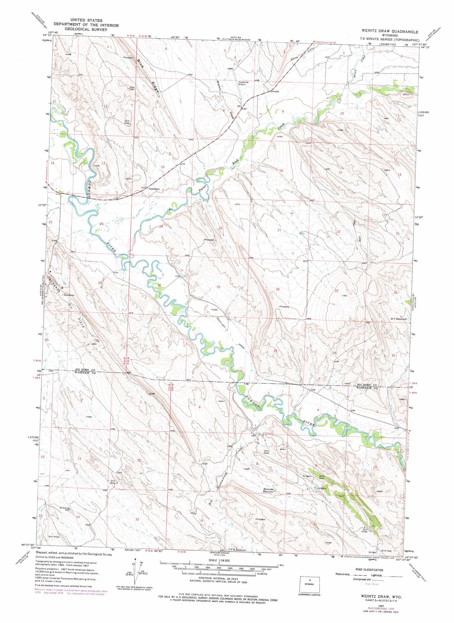
USGS Topo Quad 44107b6 - 1:24,000 scale
| Topo Map Name: | Weintz Draw |
| USGS Topo Quad ID: | 44107b6 |
| Print Size: | ca. 21 1/4" wide x 27" high |
| Southeast Coordinates: | 44.125° N latitude / 107.625° W longitude |
| Map Center Coordinates: | 44.1875° N latitude / 107.6875° W longitude |
| U.S. State: | WY |
| Filename: | o44107b6.jpg |
| Download Map JPG Image: | Weintz Draw topo map 1:24,000 scale |
| Map Type: | Topographic |
| Topo Series: | 7.5´ |
| Map Scale: | 1:24,000 |
| Source of Map Images: | United States Geological Survey (USGS) |
| Alternate Map Versions: |
Weintz Draw WY 1967, updated 1971 Download PDF Buy paper map Weintz Draw WY 1967, updated 1978 Download PDF Buy paper map Weintz Draw WY 2012 Download PDF Buy paper map Weintz Draw WY 2015 Download PDF Buy paper map |
1:24,000 Topo Quads surrounding Weintz Draw
Wild Horse Flats |
Manderson Ne |
White Sulphur Spring |
Bush Butte |
Spanish Point |
Manderson |
Manderson Se |
Flitner Reservoir |
Hyatt Ranch |
Allen Draw |
Rairden |
Mcdermotts Butte |
Weintz Draw |
Hyattville |
Pierce Draw |
Worland |
Worland Se |
Broom Draw |
Wild Horse Hill |
Ten Sleep |
Banjo Flats West |
Banjo Flats East |
Cabin Fork |
Castle Gardens |
Joe Emge Creek |
> Back to 44107a1 at 1:100,000 scale
> Back to 44106a1 at 1:250,000 scale
> Back to U.S. Topo Maps home
Weintz Draw topo map: Gazetteer
Weintz Draw: Canals
Ninetysix Canal elevation 1269m 4163′Weintz Draw: Oilfields
Bonanza Oil Field elevation 1381m 4530′Weintz Draw: Reservoirs
Brewster Reservoir elevation 1308m 4291′H G Reservoir elevation 1365m 4478′
T H Reservoir elevation 1306m 4284′
Weintz Draw: Streams
Alkali Creek elevation 1318m 4324′Big Cottonwood Creek elevation 1273m 4176′
Paint Rock Creek elevation 1262m 4140′
Weintz Draw: Valleys
Weintz Draw elevation 1302m 4271′Weintz Draw digital topo map on disk
Buy this Weintz Draw topo map showing relief, roads, GPS coordinates and other geographical features, as a high-resolution digital map file on DVD:
Eastern Wyoming & Western South Dakota
Buy digital topo maps: Eastern Wyoming & Western South Dakota