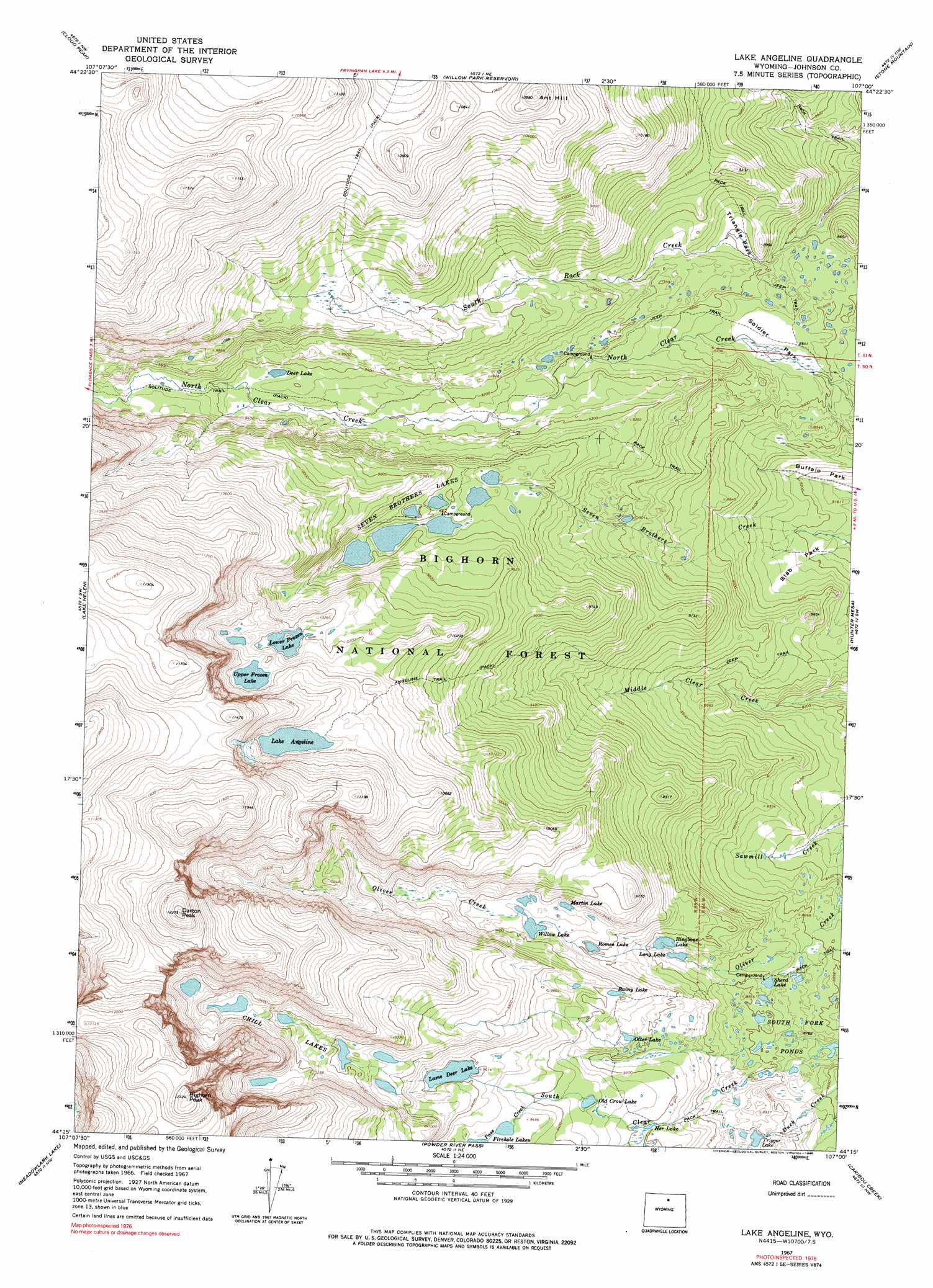
Lake Angeline Topo Map Wyoming
To zoom in, hover over the map of Lake Angeline
USGS Topo Quad 44107c1 - 1:24,000 scale
| Topo Map Name: | Lake Angeline |
| USGS Topo Quad ID: | 44107c1 |
| Print Size: | ca. 21 1/4" wide x 27" high |
| Southeast Coordinates: | 44.25° N latitude / 107° W longitude |
| Map Center Coordinates: | 44.3125° N latitude / 107.0625° W longitude |
| U.S. State: | WY |
| Filename: | o44107c1.jpg |
| Download Map JPG Image: | Lake Angeline topo map 1:24,000 scale |
| Map Type: | Topographic |
| Topo Series: | 7.5´ |
| Map Scale: | 1:24,000 |
| Source of Map Images: | United States Geological Survey (USGS) |
| Alternate Map Versions: |
Lake Angeline WY 1967, updated 1971 Download PDF Buy paper map Lake Angeline WY 1967, updated 1975 Download PDF Buy paper map Lake Angeline WY 1967, updated 1990 Download PDF Buy paper map Lake Angeline WY 1967, updated 1990 Download PDF Buy paper map Lake Angeline WY 1993, updated 1997 Download PDF Buy paper map Lake Angeline WY 2012 Download PDF Buy paper map Lake Angeline WY 2015 Download PDF Buy paper map |
| FStopo: | US Forest Service topo Lake Angeline is available: Download FStopo PDF Download FStopo TIF |
1:24,000 Topo Quads surrounding Lake Angeline
Dome Lake |
Park Reservoir |
Little Goose Peak |
Story |
Banner |
Shell Lake |
Cloud Peak |
Willow Park Reservoir |
Stone Mountain |
Lake De Smet West |
Lake Solitude |
Lake Helen |
Lake Angeline |
Hunter Mesa |
North Ridge |
Brokenback Narrows |
Meadowlark Lake |
Powder River Pass |
Caribou Creek |
Klondike Ranch |
Old Maid Gulch |
Onion Gulch |
Hazelton Peak |
Hazelton |
Robinson Canyon |
> Back to 44107a1 at 1:100,000 scale
> Back to 44106a1 at 1:250,000 scale
> Back to U.S. Topo Maps home
Lake Angeline topo map: Gazetteer
Lake Angeline: Dams
South Fork Pond Dam elevation 2691m 8828′Lake Angeline: Flats
Slab Park elevation 2505m 8218′Soldier Park elevation 2636m 8648′
Triangle Park elevation 2679m 8789′
Lake Angeline: Lakes
Chill Lakes elevation 3128m 10262′Deer Lake elevation 2852m 9356′
Her Lake elevation 2801m 9189′
Lake Angeline elevation 3217m 10554′
Lame Deer Lake elevation 2924m 9593′
Long Lake elevation 2716m 8910′
Lower Frozen Lake elevation 3107m 10193′
Martin Lake elevation 2841m 9320′
Old Crow Lake elevation 2840m 9317′
Otter Lake elevation 2812m 9225′
Rainy Lake elevation 2862m 9389′
Ringbone Lake elevation 2731m 8959′
Romeo Lake elevation 2804m 9199′
Seven Brothers Lakes elevation 2920m 9580′
Sherd Lake elevation 2668m 8753′
South Fork Ponds elevation 2669m 8756′
Trigger Lake elevation 2699m 8854′
Upper Frozen Lake elevation 3153m 10344′
Willow Lake elevation 2840m 9317′
Lake Angeline: Reservoirs
South Fork Pond elevation 2691m 8828′Lake Angeline: Streams
Pass Creek elevation 2862m 9389′Sawmill Creek elevation 2507m 8225′
Lake Angeline: Summits
Ant Hill elevation 3344m 10971′Bighorn Peak elevation 3755m 12319′
Darton Peak elevation 3735m 12253′
Lake Angeline: Trails
Angeline Trail elevation 2956m 9698′Lake Angeline digital topo map on disk
Buy this Lake Angeline topo map showing relief, roads, GPS coordinates and other geographical features, as a high-resolution digital map file on DVD:
Eastern Wyoming & Western South Dakota
Buy digital topo maps: Eastern Wyoming & Western South Dakota