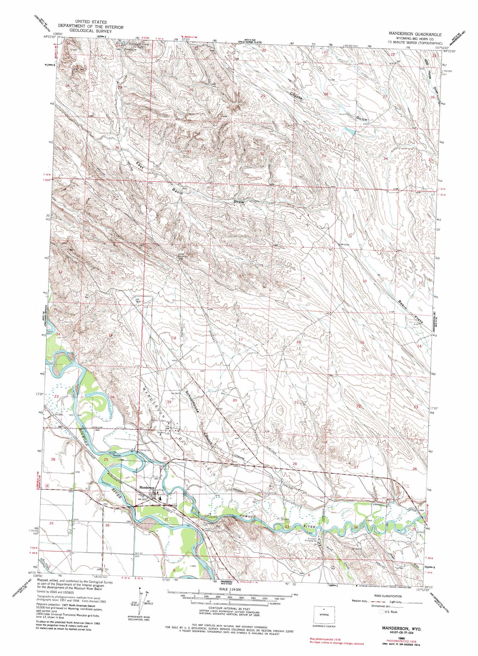
Manderson Topo Map Wyoming
To zoom in, hover over the map of Manderson
USGS Topo Quad 44107c8 - 1:24,000 scale
| Topo Map Name: | Manderson |
| USGS Topo Quad ID: | 44107c8 |
| Print Size: | ca. 21 1/4" wide x 27" high |
| Southeast Coordinates: | 44.25° N latitude / 107.875° W longitude |
| Map Center Coordinates: | 44.3125° N latitude / 107.9375° W longitude |
| U.S. State: | WY |
| Filename: | o44107c8.jpg |
| Download Map JPG Image: | Manderson topo map 1:24,000 scale |
| Map Type: | Topographic |
| Topo Series: | 7.5´ |
| Map Scale: | 1:24,000 |
| Source of Map Images: | United States Geological Survey (USGS) |
| Alternate Map Versions: |
Manderson WY 1960, updated 1962 Download PDF Buy paper map Manderson WY 1960, updated 1985 Download PDF Buy paper map Manderson WY 2012 Download PDF Buy paper map Manderson WY 2015 Download PDF Buy paper map |
1:24,000 Topo Quads surrounding Manderson
Sheep Canyon |
Greybull North |
Devils Kitchen |
Shell |
Black Mountain |
Gould Butte |
Greybull South |
Wild Horse Flats |
Manderson Ne |
White Sulphur Spring |
Jones Reservoir |
Orchard Bench |
Manderson |
Manderson Se |
Flitner Reservoir |
Schuster Flats Nw |
Schuster Flats Ne |
Rairden |
Mcdermotts Butte |
Weintz Draw |
Schuster Flats |
Schuster Flats Se |
Worland |
Worland Se |
Broom Draw |
> Back to 44107a1 at 1:100,000 scale
> Back to 44106a1 at 1:250,000 scale
> Back to U.S. Topo Maps home
Manderson topo map: Gazetteer
Manderson: Canals
Harmony Ditch elevation 1199m 3933′Manderson: Mines
Flagstaff Mine elevation 1186m 3891′Rogers and Gapin Mine elevation 1184m 3884′
Valley Ranch Mine elevation 1183m 3881′
Manderson: Oilfields
Manderson Oil Field elevation 1211m 3973′Torchlight Dome Oil Field elevation 1253m 4110′
Manderson: Populated Places
Manderson elevation 1186m 3891′Manderson: Streams
Dobie Creek elevation 1175m 3854′Nowood River elevation 1179m 3868′
Sand Creek elevation 1194m 3917′
Manderson: Valleys
Dead Horse Gulch elevation 1204m 3950′Schoolhouse Gulch elevation 1185m 3887′
Manderson digital topo map on disk
Buy this Manderson topo map showing relief, roads, GPS coordinates and other geographical features, as a high-resolution digital map file on DVD:
Eastern Wyoming & Western South Dakota
Buy digital topo maps: Eastern Wyoming & Western South Dakota