Monarch Topo Map Wyoming
To zoom in, hover over the map of Monarch
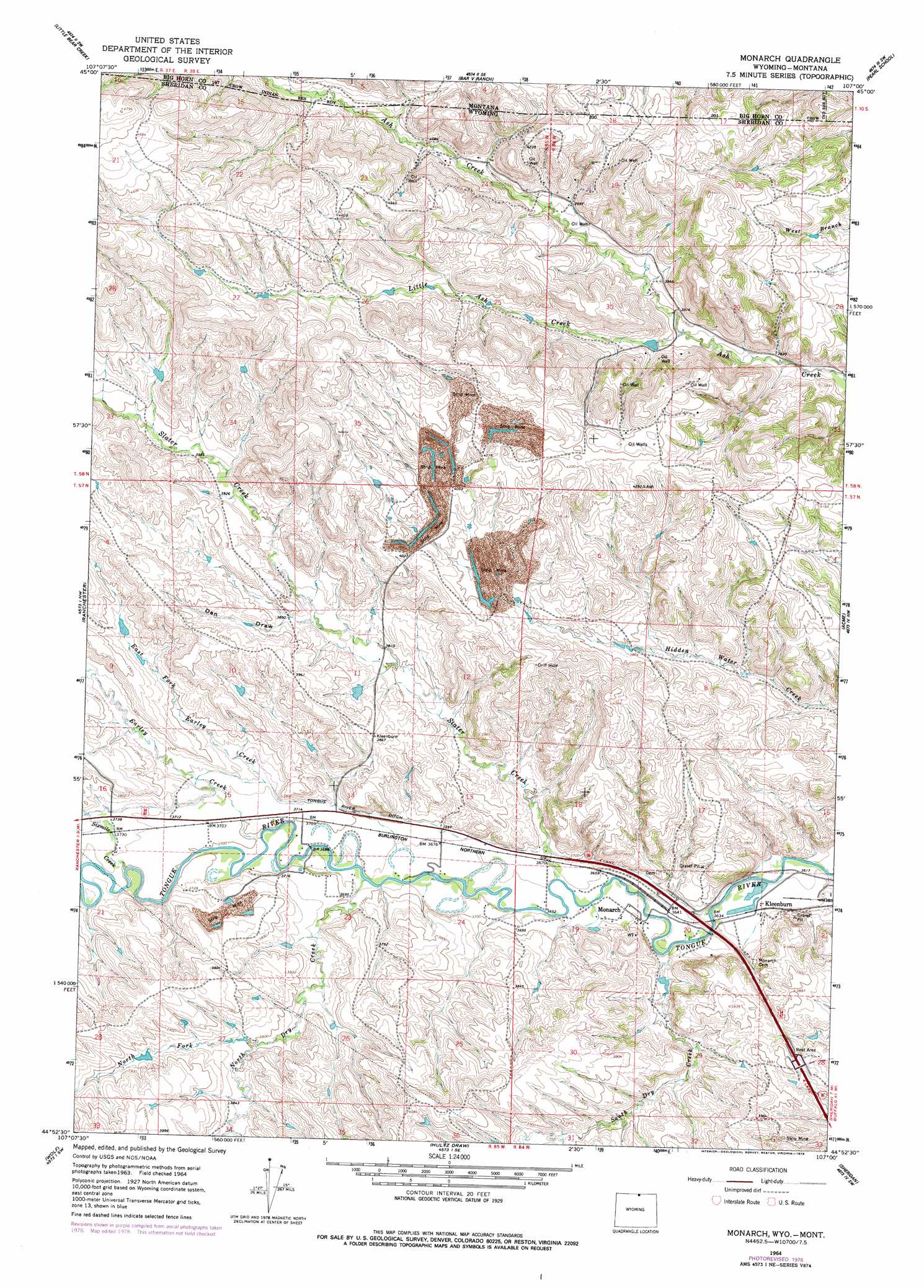
USGS Topo Quad 44107h1 - 1:24,000 scale
| Topo Map Name: | Monarch |
| USGS Topo Quad ID: | 44107h1 |
| Print Size: | ca. 21 1/4" wide x 27" high |
| Southeast Coordinates: | 44.875° N latitude / 107° W longitude |
| Map Center Coordinates: | 44.9375° N latitude / 107.0625° W longitude |
| U.S. States: | WY, MT |
| Filename: | o44107h1.jpg |
| Download Map JPG Image: | Monarch topo map 1:24,000 scale |
| Map Type: | Topographic |
| Topo Series: | 7.5´ |
| Map Scale: | 1:24,000 |
| Source of Map Images: | United States Geological Survey (USGS) |
| Alternate Map Versions: |
Monarch WY 1964, updated 1967 Download PDF Buy paper map Monarch WY 1964, updated 1978 Download PDF Buy paper map Monarch WY 2011 Download PDF Buy paper map Monarch WY 2012 Download PDF Buy paper map Monarch WY 2015 Download PDF Buy paper map |
1:24,000 Topo Quads surrounding Monarch
Wyola Ne |
Kid Creek |
Bar V Ranch Ne |
Half Moon Hill |
Tongue River Dam |
Pass Creek East |
Little Bear Creek |
Bar V Ranch |
Pearl School |
Decker |
Dayton North |
Ranchester |
Monarch |
Acme |
Bar N Draw |
Dayton South |
Wolf |
Hultz Draw |
Sheridan |
Wyarno |
Walker Mountain |
Beckton |
Beaver Creek Hills |
Big Horn |
Buffalo Run Creek |
> Back to 44107e1 at 1:100,000 scale
> Back to 44106a1 at 1:250,000 scale
> Back to U.S. Topo Maps home
Monarch topo map: Gazetteer
Monarch: Canals
Tongue River Ditch elevation 1135m 3723′Monarch: Dams
Baldwin Dam elevation 1271m 4169′Meredith Dam elevation 1206m 3956′
Monarch: Mines
Acme Number One Mine elevation 1138m 3733′Acme Number Three Mine elevation 1174m 3851′
Armstrong Mine elevation 1164m 3818′
Big Horn Mine elevation 1215m 3986′
Black Mountain Mine elevation 1165m 3822′
Buffalo Strip Mine elevation 1149m 3769′
Carney Mine Number Forty-Four elevation 1181m 3874′
Conable Prospect Mine elevation 1201m 3940′
Dietz Number One Mine elevation 1175m 3854′
Guernsey Stone Quarry elevation 1178m 3864′
Kleenburn Coal Tipple Mine elevation 1142m 3746′
Kool Number Forty-six Mine elevation 1123m 3684′
Masters Mine elevation 1138m 3733′
Model Mine elevation 1165m 3822′
Monarch Number Five Mine elevation 1121m 3677′
New Monarch Mine elevation 1165m 3822′
Old Monarch Mine elevation 1142m 3746′
Riverside Mine elevation 1138m 3733′
Welch Mine elevation 1159m 3802′
Welch Strip Mine elevation 1173m 3848′
Monarch: Populated Places
Kleenburn elevation 1110m 3641′Monarch elevation 1113m 3651′
Monarch: Reservoirs
Baldwin Reservoir elevation 1271m 4169′Meredith Reservoir elevation 1206m 3956′
Monarch: Streams
Earley Creek elevation 1123m 3684′East Fork Earley Creek elevation 1137m 3730′
Little Ash Creek elevation 1184m 3884′
North Dry Creek elevation 1122m 3681′
North Fork North Dry Creek elevation 1159m 3802′
Sixmile Creek elevation 1129m 3704′
Slater Creek elevation 1116m 3661′
South Dry Creek elevation 1110m 3641′
Monarch: Valleys
Dan Draw elevation 1169m 3835′Monarch digital topo map on disk
Buy this Monarch topo map showing relief, roads, GPS coordinates and other geographical features, as a high-resolution digital map file on DVD:
Eastern Wyoming & Western South Dakota
Buy digital topo maps: Eastern Wyoming & Western South Dakota