Iron Creek Topo Map Wyoming
To zoom in, hover over the map of Iron Creek
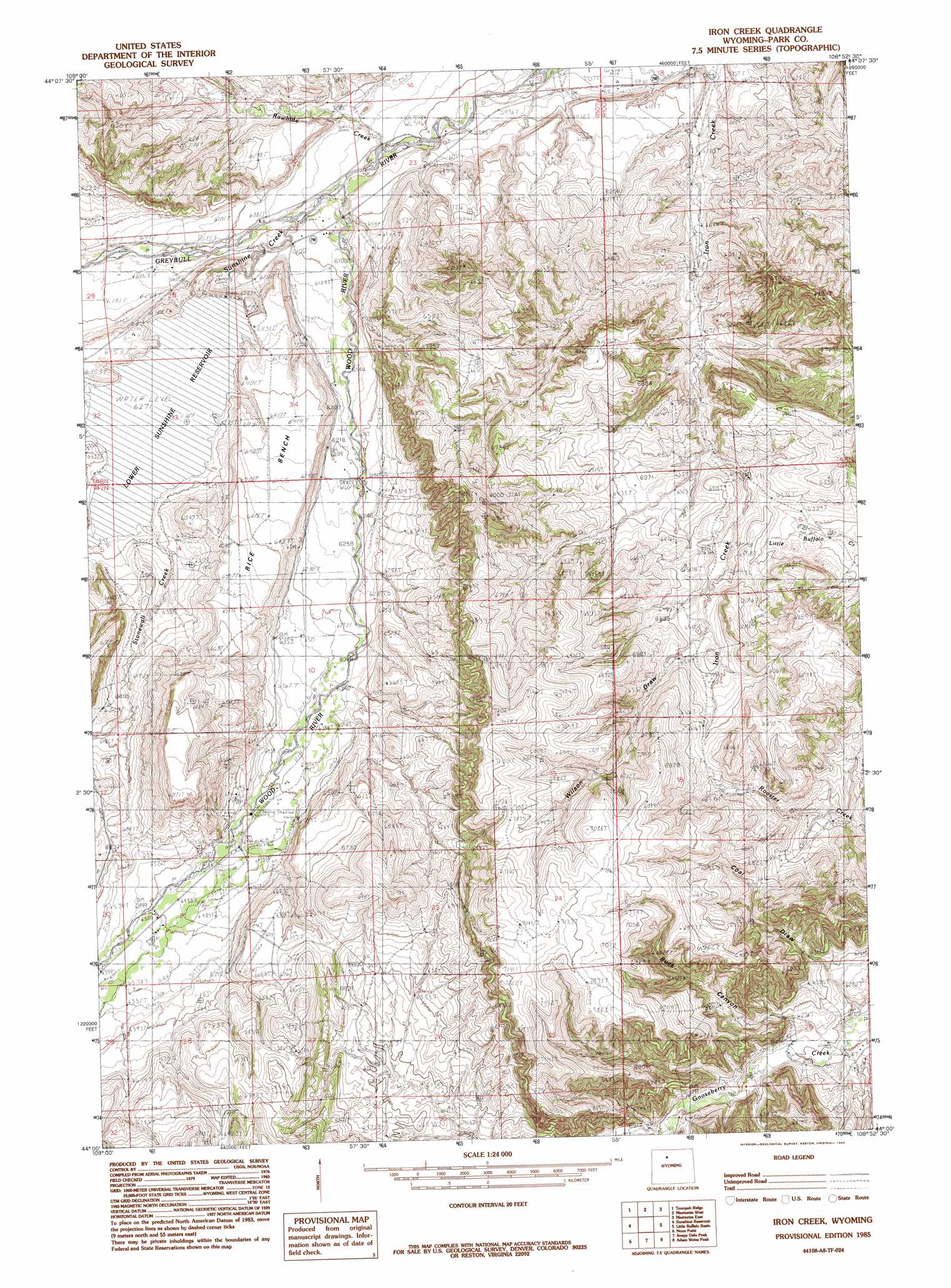
USGS Topo Quad 44108a8 - 1:24,000 scale
| Topo Map Name: | Iron Creek |
| USGS Topo Quad ID: | 44108a8 |
| Print Size: | ca. 21 1/4" wide x 27" high |
| Southeast Coordinates: | 44° N latitude / 108.875° W longitude |
| Map Center Coordinates: | 44.0625° N latitude / 108.9375° W longitude |
| U.S. State: | WY |
| Filename: | o44108a8.jpg |
| Download Map JPG Image: | Iron Creek topo map 1:24,000 scale |
| Map Type: | Topographic |
| Topo Series: | 7.5´ |
| Map Scale: | 1:24,000 |
| Source of Map Images: | United States Geological Survey (USGS) |
| Alternate Map Versions: |
Iron Creek WY 1985, updated 1985 Download PDF Buy paper map Iron Creek WY 2012 Download PDF Buy paper map Iron Creek WY 2015 Download PDF Buy paper map |
1:24,000 Topo Quads surrounding Iron Creek
Devils Tooth |
Horner Creek |
Elk Butte |
Sleepers Ranch |
Sheets Flat |
Thomas Reservoir |
Tonopah Ridge |
Meeteetse West |
Meeteetse East |
Wilson Spring |
Pitchfork |
Sunshine Reservoir |
Iron Creek |
Little Buffalo Basin |
Hillberry Rim |
Dick Creek Lakes |
Noon Point |
Soapy Dale Peak |
Adam Weiss Peak |
Grass Creek |
Twin Peaks |
Cottonwood Peak |
Milk Creek |
Twentyone Creek |
Crater Sink |
> Back to 44108a1 at 1:100,000 scale
> Back to 44108a1 at 1:250,000 scale
> Back to U.S. Topo Maps home
Iron Creek topo map: Gazetteer
Iron Creek: Canals
Only Chance Ditch elevation 2017m 6617′Pappapau Ditch elevation 1901m 6236′
Iron Creek: Dams
Iron Creek Dam elevation 1859m 6099′Lower Sunshine Dam elevation 1913m 6276′
Iron Creek: Mines
Barling Pit West elevation 1809m 5935′Bennion Pit elevation 1943m 6374′
Christipherson Mine elevation 2011m 6597′
Iron Creek: Populated Places
Dumbell elevation 1876m 6154′Sunshine elevation 1982m 6502′
Iron Creek: Reservoirs
Iron Creek Reservoir elevation 1859m 6099′Lower Sunshine Reservoir elevation 1913m 6276′
Iron Creek: Streams
Rawhide Creek elevation 1827m 5994′Stonewall Creek elevation 1914m 6279′
Stonewall Creek elevation 1913m 6276′
Sunshine Creek elevation 1836m 6023′
Wood River elevation 1834m 6017′
Iron Creek digital topo map on disk
Buy this Iron Creek topo map showing relief, roads, GPS coordinates and other geographical features, as a high-resolution digital map file on DVD: