Dead Indian Hill Topo Map Wyoming
To zoom in, hover over the map of Dead Indian Hill
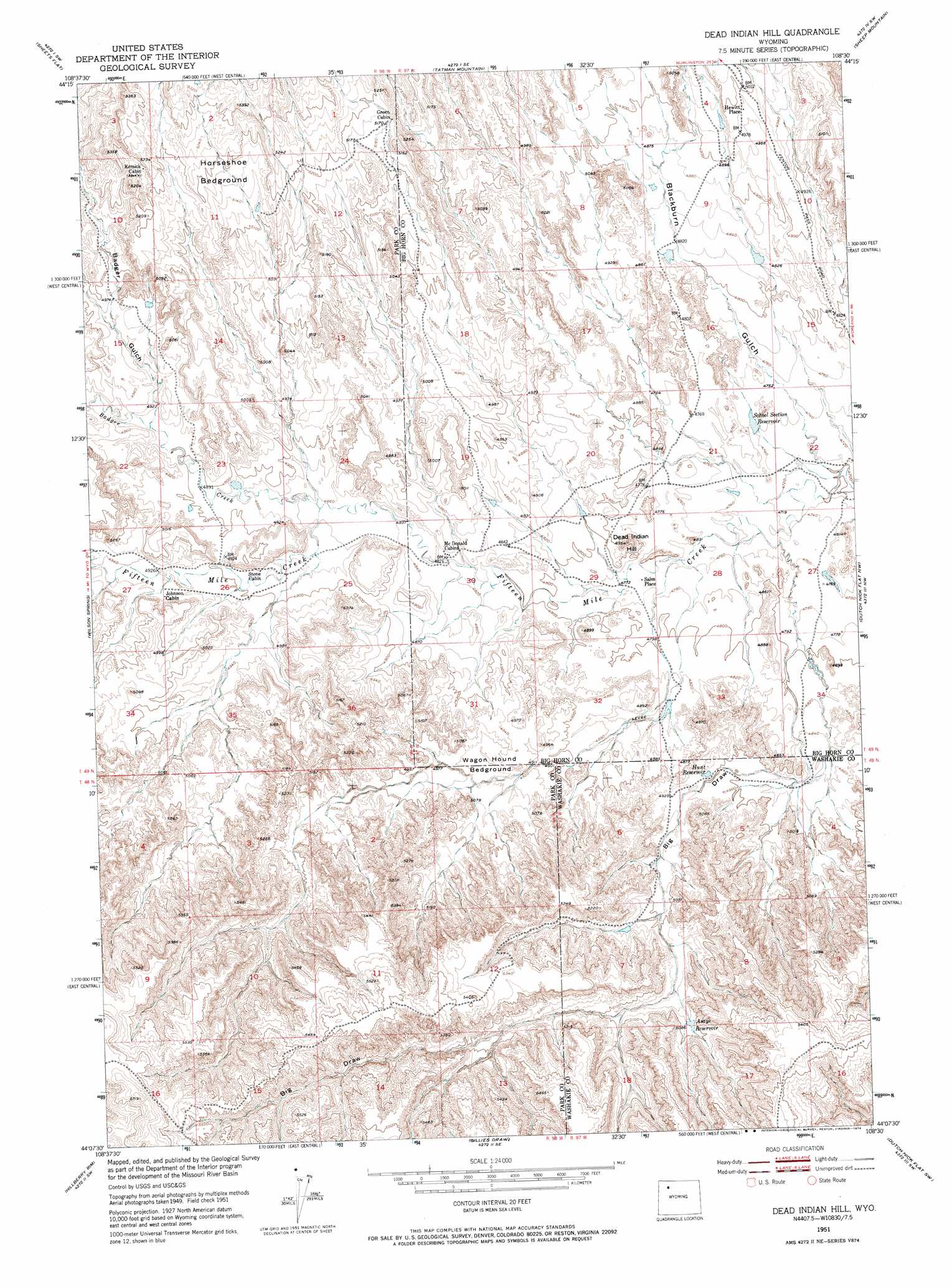
USGS Topo Quad 44108b5 - 1:24,000 scale
| Topo Map Name: | Dead Indian Hill |
| USGS Topo Quad ID: | 44108b5 |
| Print Size: | ca. 21 1/4" wide x 27" high |
| Southeast Coordinates: | 44.125° N latitude / 108.5° W longitude |
| Map Center Coordinates: | 44.1875° N latitude / 108.5625° W longitude |
| U.S. State: | WY |
| Filename: | o44108b5.jpg |
| Download Map JPG Image: | Dead Indian Hill topo map 1:24,000 scale |
| Map Type: | Topographic |
| Topo Series: | 7.5´ |
| Map Scale: | 1:24,000 |
| Source of Map Images: | United States Geological Survey (USGS) |
| Alternate Map Versions: |
Dead Indian Hill WY 1951, updated 1953 Download PDF Buy paper map Dead Indian Hill WY 1951, updated 1974 Download PDF Buy paper map Dead Indian Hill WY 2012 Download PDF Buy paper map Dead Indian Hill WY 2015 Download PDF Buy paper map |
1:24,000 Topo Quads surrounding Dead Indian Hill
Eagle Pass |
Y U Bench Nw |
Y U Bench Ne |
Burlington |
Otto |
Sleepers Ranch |
Sheets Flat |
Tatman Mountain |
Sheep Mountain |
Wardel Reservoir |
Meeteetse East |
Wilson Spring |
Dead Indian Hill |
Dutch Nick Flat Nw |
Sucker Dam |
Little Buffalo Basin |
Hillberry Rim |
Gillies Draw |
Dutch Nick Flat Sw |
Dutch Nick Flat |
Adam Weiss Peak |
Grass Creek |
Red Ridge |
Blue Mesa West |
Blue Mesa East |
> Back to 44108a1 at 1:100,000 scale
> Back to 44108a1 at 1:250,000 scale
> Back to U.S. Topo Maps home
Dead Indian Hill topo map: Gazetteer
Dead Indian Hill: Flats
Horseshoe Bedground elevation 1581m 5187′Wagon Hound Bedground elevation 1508m 4947′
Dead Indian Hill: Populated Places
Hewitt Place elevation 1518m 4980′Sales Place elevation 1455m 4773′
Dead Indian Hill: Reservoirs
Asays Reservoir elevation 1550m 5085′Hunt Reservoir elevation 1497m 4911′
School Section Reservoir elevation 1446m 4744′
Dead Indian Hill: Streams
Badger Creek elevation 1481m 4858′Dead Indian Hill: Summits
Dead Indian Hill elevation 1492m 4895′Dead Indian Hill: Valleys
Badger Gulch elevation 1497m 4911′Big Draw elevation 1441m 4727′
Blackburn Gulch elevation 1434m 4704′
Dead Indian Hill digital topo map on disk
Buy this Dead Indian Hill topo map showing relief, roads, GPS coordinates and other geographical features, as a high-resolution digital map file on DVD: