Burlington Topo Map Wyoming
To zoom in, hover over the map of Burlington
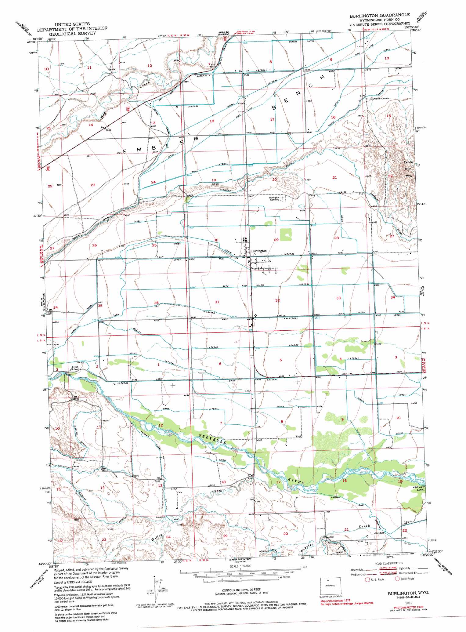
USGS Topo Quad 44108d4 - 1:24,000 scale
| Topo Map Name: | Burlington |
| USGS Topo Quad ID: | 44108d4 |
| Print Size: | ca. 21 1/4" wide x 27" high |
| Southeast Coordinates: | 44.375° N latitude / 108.375° W longitude |
| Map Center Coordinates: | 44.4375° N latitude / 108.4375° W longitude |
| U.S. State: | WY |
| Filename: | o44108d4.jpg |
| Download Map JPG Image: | Burlington topo map 1:24,000 scale |
| Map Type: | Topographic |
| Topo Series: | 7.5´ |
| Map Scale: | 1:24,000 |
| Source of Map Images: | United States Geological Survey (USGS) |
| Alternate Map Versions: |
Burlington WY 1951, updated 1952 Download PDF Buy paper map Burlington WY 1951, updated 1976 Download PDF Buy paper map Burlington WY 1951, updated 1986 Download PDF Buy paper map Burlington WY 2012 Download PDF Buy paper map Burlington WY 2015 Download PDF Buy paper map |
1:24,000 Topo Quads surrounding Burlington
Gilmore Hill Nw |
Gilmore Hill Ne |
Jack Horner Reservoir |
North Emblem Reservoir |
Spence |
Gilmore Hill |
Gilmore Hill Se |
Emblem |
Emblem Se |
Sheep Canyon |
Y U Bench Nw |
Y U Bench Ne |
Burlington |
Otto |
Gould Butte |
Sheets Flat |
Tatman Mountain |
Sheep Mountain |
Wardel Reservoir |
Jones Reservoir |
Wilson Spring |
Dead Indian Hill |
Dutch Nick Flat Nw |
Sucker Dam |
Schuster Flats Nw |
> Back to 44108a1 at 1:100,000 scale
> Back to 44108a1 at 1:250,000 scale
> Back to U.S. Topo Maps home
Burlington topo map: Gazetteer
Burlington: Benches
Emblem Bench elevation 1382m 4534′Burlington: Canals
42 Lateral elevation 1388m 4553′Bahr Lateral elevation 1356m 4448′
Bank Lateral elevation 1358m 4455′
Beck and Allen Lateral elevation 1344m 4409′
Brown and Croxell Ditch elevation 1320m 4330′
German Ditch elevation 1380m 4527′
Maller Ditch elevation 1396m 4580′
McNiven Lateral elevation 1349m 4425′
Pearce Lateral elevation 1340m 4396′
Riley Lateral elevation 1363m 4471′
Saint Joe Canal elevation 1346m 4416′
Tatman Canal elevation 1361m 4465′
Town Lateral elevation 1347m 4419′
Burlington: Populated Places
Burlington elevation 1351m 4432′Burlington: Streams
Willow Creek elevation 1329m 4360′Burlington: Summits
Table Mountain elevation 1444m 4737′Burlington digital topo map on disk
Buy this Burlington topo map showing relief, roads, GPS coordinates and other geographical features, as a high-resolution digital map file on DVD: