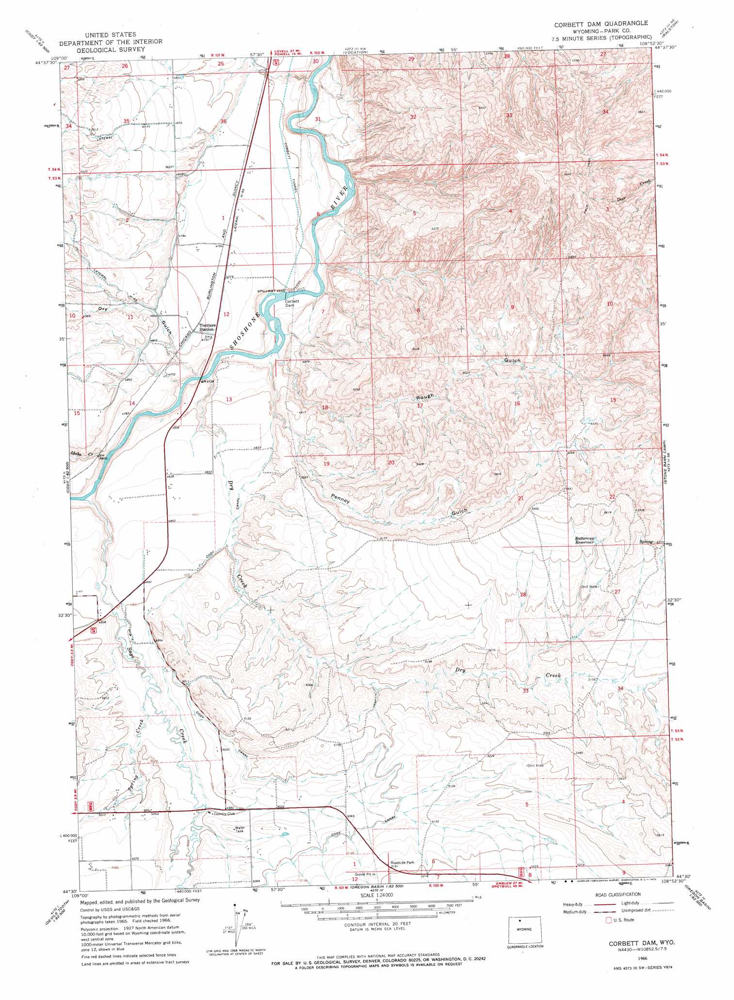
Corbett Dam Topo Map Wyoming
To zoom in, hover over the map of Corbett Dam
USGS Topo Quad 44108e8 - 1:24,000 scale
| Topo Map Name: | Corbett Dam |
| USGS Topo Quad ID: | 44108e8 |
| Print Size: | ca. 21 1/4" wide x 27" high |
| Southeast Coordinates: | 44.5° N latitude / 108.875° W longitude |
| Map Center Coordinates: | 44.5625° N latitude / 108.9375° W longitude |
| U.S. State: | WY |
| Filename: | o44108e8.jpg |
| Download Map JPG Image: | Corbett Dam topo map 1:24,000 scale |
| Map Type: | Topographic |
| Topo Series: | 7.5´ |
| Map Scale: | 1:24,000 |
| Source of Map Images: | United States Geological Survey (USGS) |
| Alternate Map Versions: |
Corbett Dam WY 1966, updated 1970 Download PDF Buy paper map Corbett Dam WY 2012 Download PDF Buy paper map Corbett Dam WY 2015 Download PDF Buy paper map |
1:24,000 Topo Quads surrounding Corbett Dam
Chapman Bench |
Badlands Hills |
Elk Basin Sw |
Elk Basin Se |
Garland |
Goff Lake |
Eaglenest Basin |
Vocation |
Ralston |
Gilmore Hill Nw |
Shoshone Canyon |
Cody |
Corbett Dam |
Stone Barn Camp |
Gilmore Hill |
Irma Flats |
Indian Pass |
Oregon Basin |
Eagle Pass |
Y U Bench Nw |
Devils Tooth |
Horner Creek |
Elk Butte |
Sleepers Ranch |
Sheets Flat |
> Back to 44108e1 at 1:100,000 scale
> Back to 44108a1 at 1:250,000 scale
> Back to U.S. Topo Maps home
Corbett Dam topo map: Gazetteer
Corbett Dam: Canals
Lateral H-65 elevation 1485m 4872′Lateral H-71 elevation 1529m 5016′
Corbett Dam: Dams
Corbett Dam elevation 1410m 4625′Corbett Dam: Mines
Cody Mine elevation 1485m 4872′Dutton Pit Mine elevation 1501m 4924′
Torezon Mine elevation 1450m 4757′
Corbett Dam: Reservoirs
Buttercup Reservoir elevation 1649m 5410′Corbett Dam: Streams
Dry Creek elevation 1423m 4668′Idaho Creek elevation 1433m 4701′
Sage Creek elevation 1438m 4717′
Spring Creek elevation 1500m 4921′
Corbett Dam: Tunnels
Corbett Tunnel elevation 1434m 4704′Corbett Dam: Valleys
Dry Gulch elevation 1432m 4698′Penney Gulch elevation 1416m 4645′
Rough Gulch elevation 1415m 4642′
Corbett Dam digital topo map on disk
Buy this Corbett Dam topo map showing relief, roads, GPS coordinates and other geographical features, as a high-resolution digital map file on DVD: