Lovell Topo Map Wyoming
To zoom in, hover over the map of Lovell
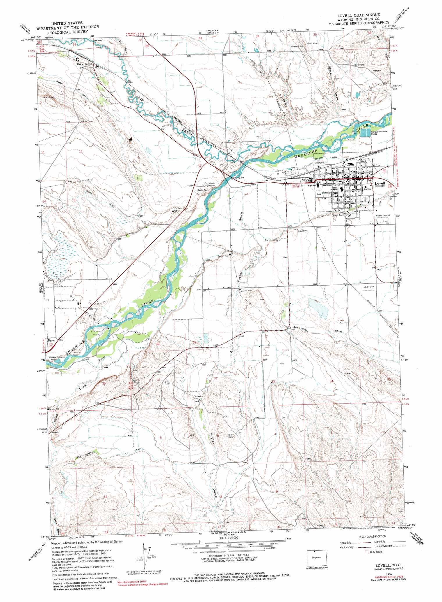
USGS Topo Quad 44108g4 - 1:24,000 scale
| Topo Map Name: | Lovell |
| USGS Topo Quad ID: | 44108g4 |
| Print Size: | ca. 21 1/4" wide x 27" high |
| Southeast Coordinates: | 44.75° N latitude / 108.375° W longitude |
| Map Center Coordinates: | 44.8125° N latitude / 108.4375° W longitude |
| U.S. State: | WY |
| Filename: | o44108g4.jpg |
| Download Map JPG Image: | Lovell topo map 1:24,000 scale |
| Map Type: | Topographic |
| Topo Series: | 7.5´ |
| Map Scale: | 1:24,000 |
| Source of Map Images: | United States Geological Survey (USGS) |
| Alternate Map Versions: |
Lovell WY 1966, updated 1970 Download PDF Buy paper map Lovell WY 1966, updated 1982 Download PDF Buy paper map Lovell WY 1966, updated 1990 Download PDF Buy paper map Lovell WY 1966, updated 1990 Download PDF Buy paper map Lovell WY 2012 Download PDF Buy paper map Lovell WY 2015 Download PDF Buy paper map |
1:24,000 Topo Quads surrounding Lovell
Warren |
Bear Canyon |
Red Pryor Mountain |
Mystery Cave |
Hillsboro |
Deaver Reservoir |
Frannie |
Cowley |
Sykes Spring |
Natural Trap Cave |
Garland |
Byron |
Lovell |
Lovell Lakes |
Kane |
Gilmore Hill Nw |
Gilmore Hill Ne |
Jack Horner Reservoir |
North Emblem Reservoir |
Spence |
Gilmore Hill |
Gilmore Hill Se |
Emblem |
Emblem Se |
Sheep Canyon |
> Back to 44108e1 at 1:100,000 scale
> Back to 44108a1 at 1:250,000 scale
> Back to U.S. Topo Maps home
Lovell topo map: Gazetteer
Lovell: Canals
Elk Lovell Canal elevation 1250m 4101′Globe Canal elevation 1185m 3887′
Hunt Godfrey Canal elevation 1165m 3822′
Sidon Canal elevation 1245m 4084′
Lovell: Mines
City Pit Mine elevation 1181m 3874′Clark Pit Mine elevation 1165m 3822′
Cowley Mine elevation 1247m 4091′
Gypsum Quarry Number Seven Mine elevation 1169m 3835′
Nichols Sand and Gravel Pit elevation 1171m 3841′
Yellowtail Mine elevation 1170m 3838′
Lovell: Populated Places
Lovell elevation 1168m 3832′Lovell: Streams
Peterson Creek elevation 1158m 3799′Sage Creek elevation 1167m 3828′
Sage Creek elevation 1167m 3828′
Lovell: Valleys
Big Wash elevation 1193m 3914′Black Draw elevation 1164m 3818′
Foster Gulch elevation 1177m 3861′
Sand Draw elevation 1199m 3933′
Lovell digital topo map on disk
Buy this Lovell topo map showing relief, roads, GPS coordinates and other geographical features, as a high-resolution digital map file on DVD: