Yellow Mountain Topo Map Wyoming
To zoom in, hover over the map of Yellow Mountain
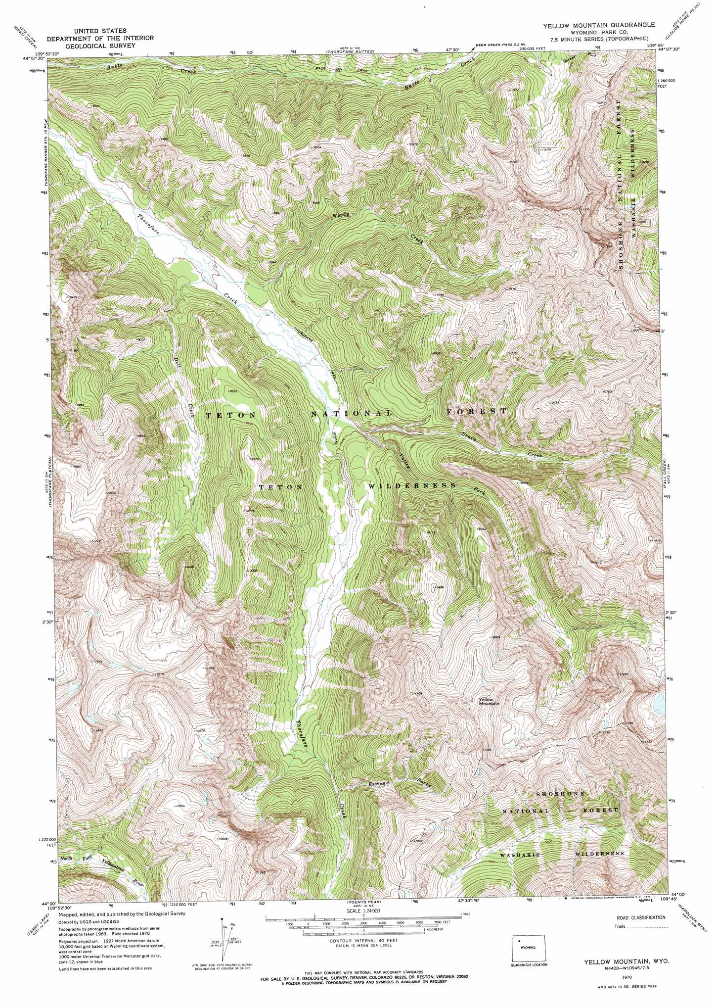
USGS Topo Quad 44109a7 - 1:24,000 scale
| Topo Map Name: | Yellow Mountain |
| USGS Topo Quad ID: | 44109a7 |
| Print Size: | ca. 21 1/4" wide x 27" high |
| Southeast Coordinates: | 44° N latitude / 109.75° W longitude |
| Map Center Coordinates: | 44.0625° N latitude / 109.8125° W longitude |
| U.S. State: | WY |
| Filename: | o44109a7.jpg |
| Download Map JPG Image: | Yellow Mountain topo map 1:24,000 scale |
| Map Type: | Topographic |
| Topo Series: | 7.5´ |
| Map Scale: | 1:24,000 |
| Source of Map Images: | United States Geological Survey (USGS) |
| Alternate Map Versions: |
Yellow Mountain WY 1970, updated 1973 Download PDF Buy paper map Yellow Mountain WY 1970, updated 1973 Download PDF Buy paper map Yellow Mountain WY 1991, updated 1997 Download PDF Buy paper map Yellow Mountain WY 2012 Download PDF Buy paper map Yellow Mountain WY 2015 Download PDF Buy paper map |
| FStopo: | US Forest Service topo Yellow Mountain is available: Download FStopo PDF Download FStopo TIF |
1:24,000 Topo Quads surrounding Yellow Mountain
Eagle Peak |
Pinnacle Mountain |
Sheep Mesa |
Lake Creek |
Ptarmigan Mountain |
The Trident |
Open Creek |
Thorofare Buttes |
Clouds Home Peak |
Valley |
Yellowstone Point |
Thorofare Plateau |
Yellow Mountain |
Fall Creek |
Needle Mountain |
Crater Lake |
Ferry Lake |
Younts Peak |
Hardluck Mountain |
Emerald Lake |
Togwotee Pass |
Dundee Meadows |
Shoshone Pass |
Five Pockets |
Snow Lake |
> Back to 44109a1 at 1:100,000 scale
> Back to 44108a1 at 1:250,000 scale
> Back to U.S. Topo Maps home
Yellow Mountain topo map: Gazetteer
Yellow Mountain: Streams
Bruin Creek elevation 2609m 8559′Dell Creek elevation 2560m 8398′
Esmond Forks elevation 2789m 9150′
North Fork Butte Creek elevation 2600m 8530′
Valley Fork elevation 2596m 8517′
Woody Creek elevation 2554m 8379′
Yellow Mountain: Summits
Yellow Mountain elevation 3460m 11351′Yellow Mountain: Trails
Butte Creek Trail elevation 2718m 8917′Yellow Mountain digital topo map on disk
Buy this Yellow Mountain topo map showing relief, roads, GPS coordinates and other geographical features, as a high-resolution digital map file on DVD: