Thorofare Buttes Topo Map Wyoming
To zoom in, hover over the map of Thorofare Buttes
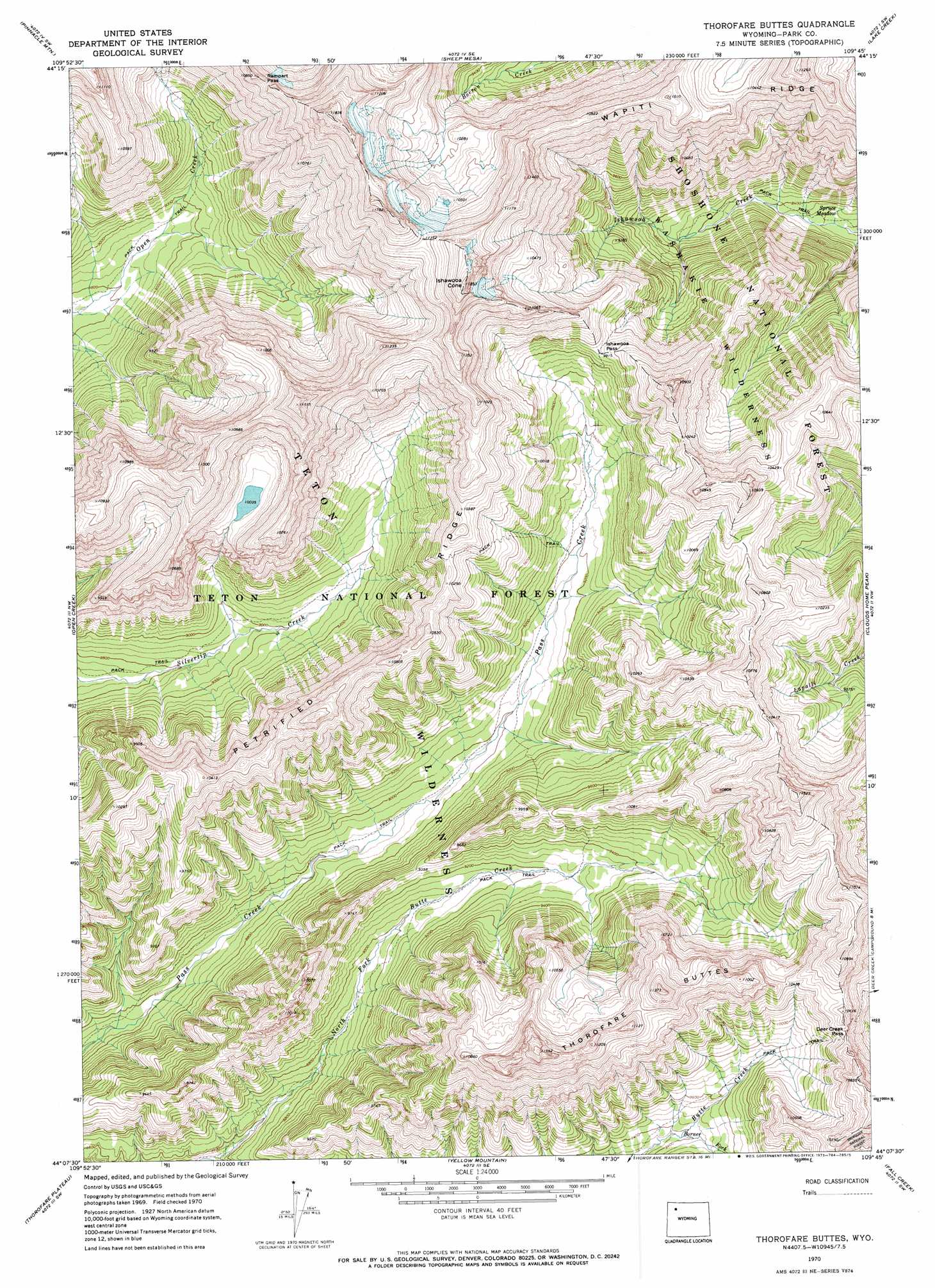
USGS Topo Quad 44109b7 - 1:24,000 scale
| Topo Map Name: | Thorofare Buttes |
| USGS Topo Quad ID: | 44109b7 |
| Print Size: | ca. 21 1/4" wide x 27" high |
| Southeast Coordinates: | 44.125° N latitude / 109.75° W longitude |
| Map Center Coordinates: | 44.1875° N latitude / 109.8125° W longitude |
| U.S. State: | WY |
| Filename: | o44109b7.jpg |
| Download Map JPG Image: | Thorofare Buttes topo map 1:24,000 scale |
| Map Type: | Topographic |
| Topo Series: | 7.5´ |
| Map Scale: | 1:24,000 |
| Source of Map Images: | United States Geological Survey (USGS) |
| Alternate Map Versions: |
Thorofare Buttes WY 1970, updated 1973 Download PDF Buy paper map Thorofare Buttes WY 1970, updated 1973 Download PDF Buy paper map Thorofare Buttes WY 1991, updated 1997 Download PDF Buy paper map Thorofare Buttes WY 1991, updated 1997 Download PDF Buy paper map Thorofare Buttes WY 2012 Download PDF Buy paper map Thorofare Buttes WY 2015 Download PDF Buy paper map |
| FStopo: | US Forest Service topo Thorofare Buttes is available: Download FStopo PDF Download FStopo TIF |
1:24,000 Topo Quads surrounding Thorofare Buttes
Plenty Coups Peak |
Eagle Creek |
Chimney Rock |
Clayton Mountain |
Flag Peak |
Eagle Peak |
Pinnacle Mountain |
Sheep Mesa |
Lake Creek |
Ptarmigan Mountain |
The Trident |
Open Creek |
Thorofare Buttes |
Clouds Home Peak |
Valley |
Yellowstone Point |
Thorofare Plateau |
Yellow Mountain |
Fall Creek |
Needle Mountain |
Crater Lake |
Ferry Lake |
Younts Peak |
Hardluck Mountain |
Emerald Lake |
> Back to 44109a1 at 1:100,000 scale
> Back to 44108a1 at 1:250,000 scale
> Back to U.S. Topo Maps home
Thorofare Buttes topo map: Gazetteer
Thorofare Buttes: Flats
Spruce Meadow elevation 2519m 8264′Thorofare Buttes: Gaps
Deer Creek Pass elevation 3171m 10403′Ishawooa Pass elevation 3026m 9927′
Rampart Pass elevation 3277m 10751′
Thorofare Buttes: Ridges
Petrified Ridge elevation 3185m 10449′Thorofare Buttes: Streams
Borner Fork elevation 2865m 9399′Thorofare Buttes: Summits
Ishawooa Cone elevation 3576m 11732′Thorofare Buttes elevation 3304m 10839′
Thorofare Buttes: Trails
Pass Creek Trail elevation 2627m 8618′Thorofare Buttes digital topo map on disk
Buy this Thorofare Buttes topo map showing relief, roads, GPS coordinates and other geographical features, as a high-resolution digital map file on DVD: