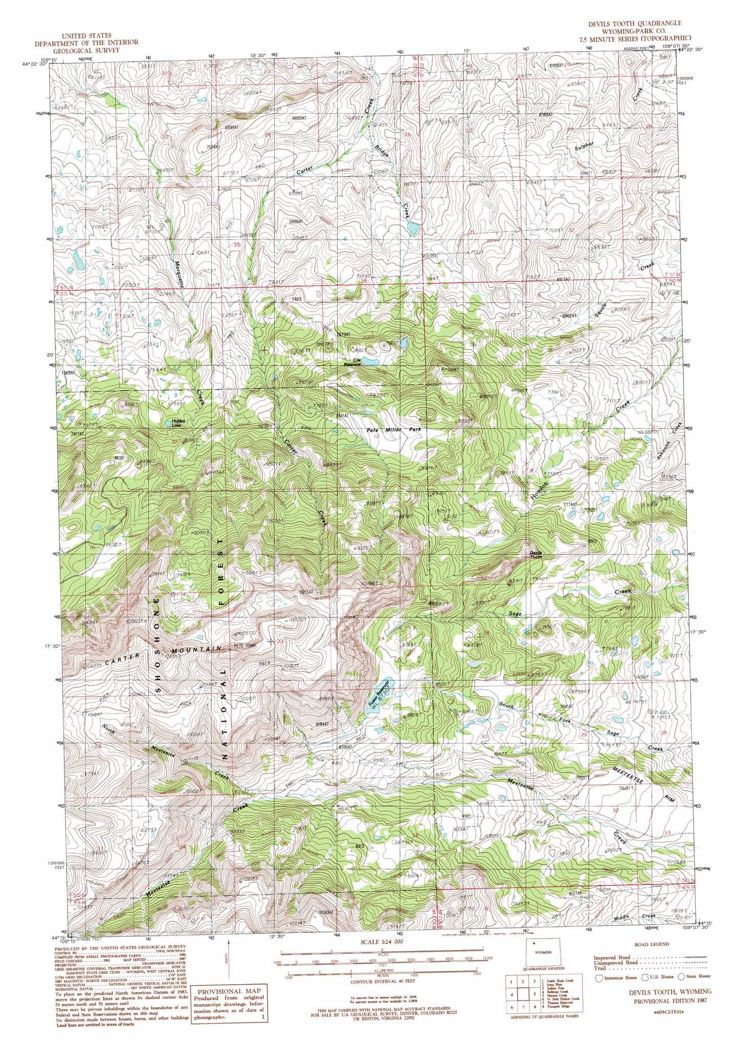
Devils Tooth Topo Map Wyoming
To zoom in, hover over the map of Devils Tooth
USGS Topo Quad 44109c2 - 1:24,000 scale
| Topo Map Name: | Devils Tooth |
| USGS Topo Quad ID: | 44109c2 |
| Print Size: | ca. 21 1/4" wide x 27" high |
| Southeast Coordinates: | 44.25° N latitude / 109.125° W longitude |
| Map Center Coordinates: | 44.3125° N latitude / 109.1875° W longitude |
| U.S. State: | WY |
| Filename: | o44109c2.jpg |
| Download Map JPG Image: | Devils Tooth topo map 1:24,000 scale |
| Map Type: | Topographic |
| Topo Series: | 7.5´ |
| Map Scale: | 1:24,000 |
| Source of Map Images: | United States Geological Survey (USGS) |
| Alternate Map Versions: |
Devils Tooth WY 1987, updated 1988 Download PDF Buy paper map Devils Tooth WY 1991, updated 1996 Download PDF Buy paper map Devils Tooth WY 1991, updated 1996 Download PDF Buy paper map Devils Tooth WY 2012 Download PDF Buy paper map Devils Tooth WY 2015 Download PDF Buy paper map |
| FStopo: | US Forest Service topo Devils Tooth is available: Download FStopo PDF Download FStopo TIF |
1:24,000 Topo Quads surrounding Devils Tooth
Jim Mountain |
Logan Mountain |
Shoshone Canyon |
Cody |
Corbett Dam |
Wapiti |
Castle Rock Creek |
Irma Flats |
Indian Pass |
Oregon Basin |
Twin Creek |
Belknap Creek |
Devils Tooth |
Horner Creek |
Elk Butte |
Aldrich Basin |
North Fork Pickett Creek |
Thomas Reservoir |
Tonopah Ridge |
Meeteetse West |
Irish Rock |
Phelps Mountain |
Pitchfork |
Sunshine Reservoir |
Iron Creek |
> Back to 44109a1 at 1:100,000 scale
> Back to 44108a1 at 1:250,000 scale
> Back to U.S. Topo Maps home
Devils Tooth topo map: Gazetteer
Devils Tooth: Dams
Darrah Dam elevation 2105m 6906′Darrah Number 1 Dam elevation 2334m 7657′
Darrah Number 2 Dam elevation 2317m 7601′
Eagle Lake Dam elevation 2197m 7208′
Foster Number 3 Dam elevation 2655m 8710′
Nina Dam elevation 2518m 8261′
Shoshone Number 1 Dam elevation 2398m 7867′
Sylvan Dam elevation 2660m 8727′
Devils Tooth: Flats
Pete Miller Park elevation 2488m 8162′Devils Tooth: Lakes
Hidden Lake elevation 2341m 7680′Devils Tooth: Reservoirs
Coe Reservoir elevation 2362m 7749′Darrah Number 1 Reservoir elevation 2334m 7657′
Darrah Number 2 Reservoir elevation 2317m 7601′
Darrah Number 3 Reservoir elevation 2105m 6906′
Eagle Lake elevation 2197m 7208′
Foster Number 3 Reservoir elevation 2655m 8710′
Foster Reservoir elevation 2660m 8727′
Nina Reservoir elevation 2518m 8261′
Shoshone Number 1 Reservoir elevation 2398m 7867′
Sylvan Reservoir elevation 2660m 8727′
Devils Tooth: Streams
Bridge Creek elevation 1890m 6200′North Meeteetse Creek elevation 2641m 8664′
Devils Tooth: Summits
Devils Tooth elevation 2588m 8490′Devils Tooth digital topo map on disk
Buy this Devils Tooth topo map showing relief, roads, GPS coordinates and other geographical features, as a high-resolution digital map file on DVD: