Wapiti Topo Map Wyoming
To zoom in, hover over the map of Wapiti
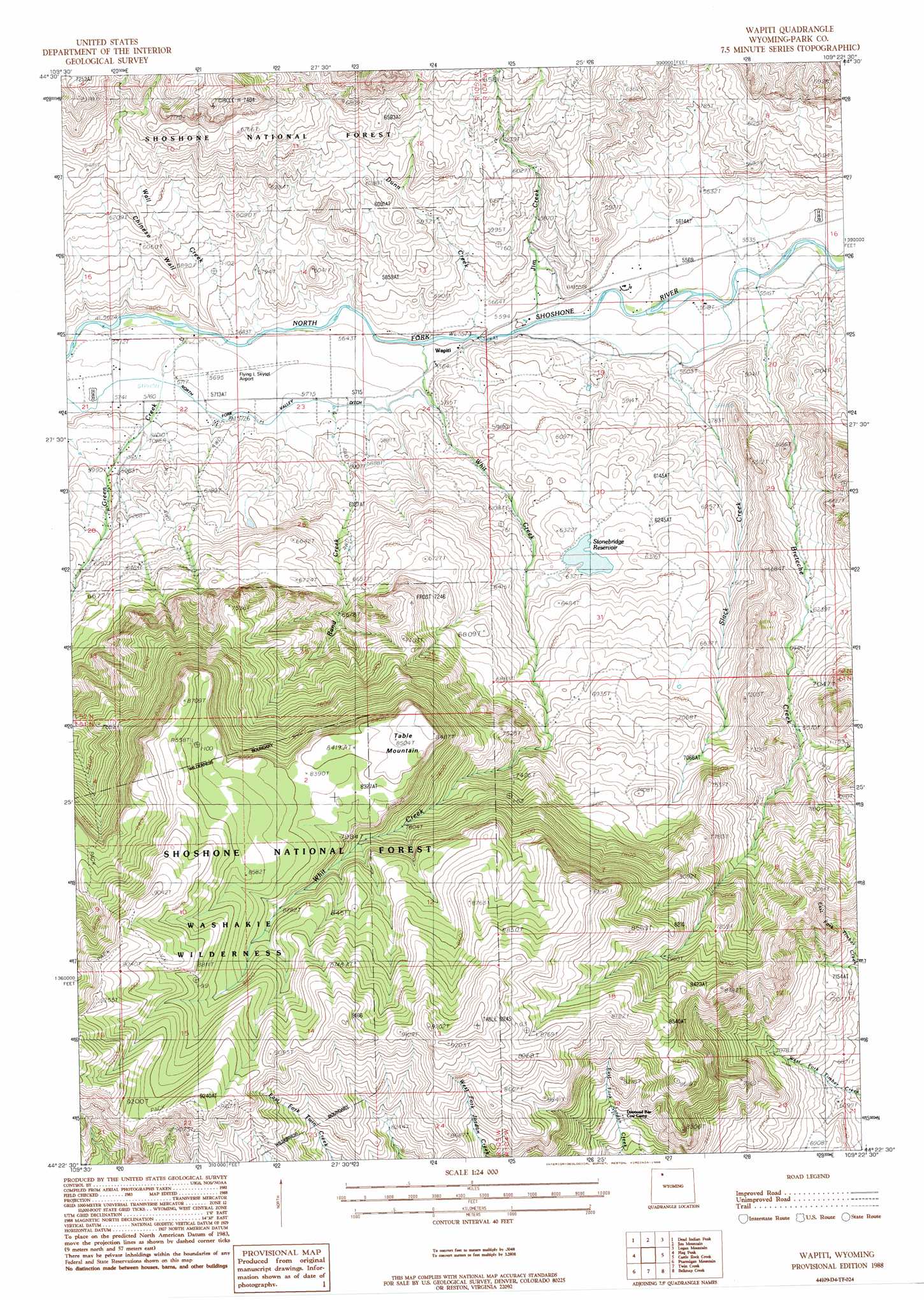
USGS Topo Quad 44109d4 - 1:24,000 scale
| Topo Map Name: | Wapiti |
| USGS Topo Quad ID: | 44109d4 |
| Print Size: | ca. 21 1/4" wide x 27" high |
| Southeast Coordinates: | 44.375° N latitude / 109.375° W longitude |
| Map Center Coordinates: | 44.4375° N latitude / 109.4375° W longitude |
| U.S. State: | WY |
| Filename: | o44109d4.jpg |
| Download Map JPG Image: | Wapiti topo map 1:24,000 scale |
| Map Type: | Topographic |
| Topo Series: | 7.5´ |
| Map Scale: | 1:24,000 |
| Source of Map Images: | United States Geological Survey (USGS) |
| Alternate Map Versions: |
Wapiti WY 1988, updated 1988 Download PDF Buy paper map Wapiti WY 1991, updated 1996 Download PDF Buy paper map Wapiti WY 1991, updated 1996 Download PDF Buy paper map Wapiti WY 2012 Download PDF Buy paper map Wapiti WY 2015 Download PDF Buy paper map |
| FStopo: | US Forest Service topo Wapiti is available: Download FStopo PDF Download FStopo TIF |
1:24,000 Topo Quads surrounding Wapiti
Geers Point |
Elkhorn Peak |
Dead Indian Meadows |
Pat O' Hara Mountain |
Goff Lake |
Jaggar Peak |
Dead Indian Peak |
Jim Mountain |
Logan Mountain |
Shoshone Canyon |
Clayton Mountain |
Flag Peak |
Wapiti |
Castle Rock Creek |
Irma Flats |
Lake Creek |
Ptarmigan Mountain |
Twin Creek |
Belknap Creek |
Devils Tooth |
Clouds Home Peak |
Valley |
Aldrich Basin |
North Fork Pickett Creek |
Thomas Reservoir |
> Back to 44109a1 at 1:100,000 scale
> Back to 44108a1 at 1:250,000 scale
> Back to U.S. Topo Maps home
Wapiti topo map: Gazetteer
Wapiti: Airports
Flying L Skytel Airport elevation 1736m 5695′Wapiti: Canals
North Fork Valley Ditch elevation 1750m 5741′Wapiti: Dams
Frost Dam elevation 1983m 6505′Stonebridge Dam elevation 1916m 6286′
Wapiti: Populated Places
Wapiti elevation 1707m 5600′Wapiti: Reservoirs
Frost Reservoir elevation 1983m 6505′Stonebridge Reservoir elevation 1912m 6272′
Wapiti: Ridges
Chinese Wall elevation 1821m 5974′Wapiti: Streams
Breteche Creek elevation 1676m 5498′Dunn Creek elevation 1702m 5583′
Green Creek elevation 1724m 5656′
Jim Creek elevation 1697m 5567′
Rand Creek elevation 1716m 5629′
Slack Creek elevation 1677m 5501′
Wall Creek elevation 1721m 5646′
Whit Creek elevation 1705m 5593′
Wapiti: Summits
Table Mountain elevation 2587m 8487′Wapiti: Trails
Table Mountain Trail elevation 2641m 8664′Wapiti digital topo map on disk
Buy this Wapiti topo map showing relief, roads, GPS coordinates and other geographical features, as a high-resolution digital map file on DVD: