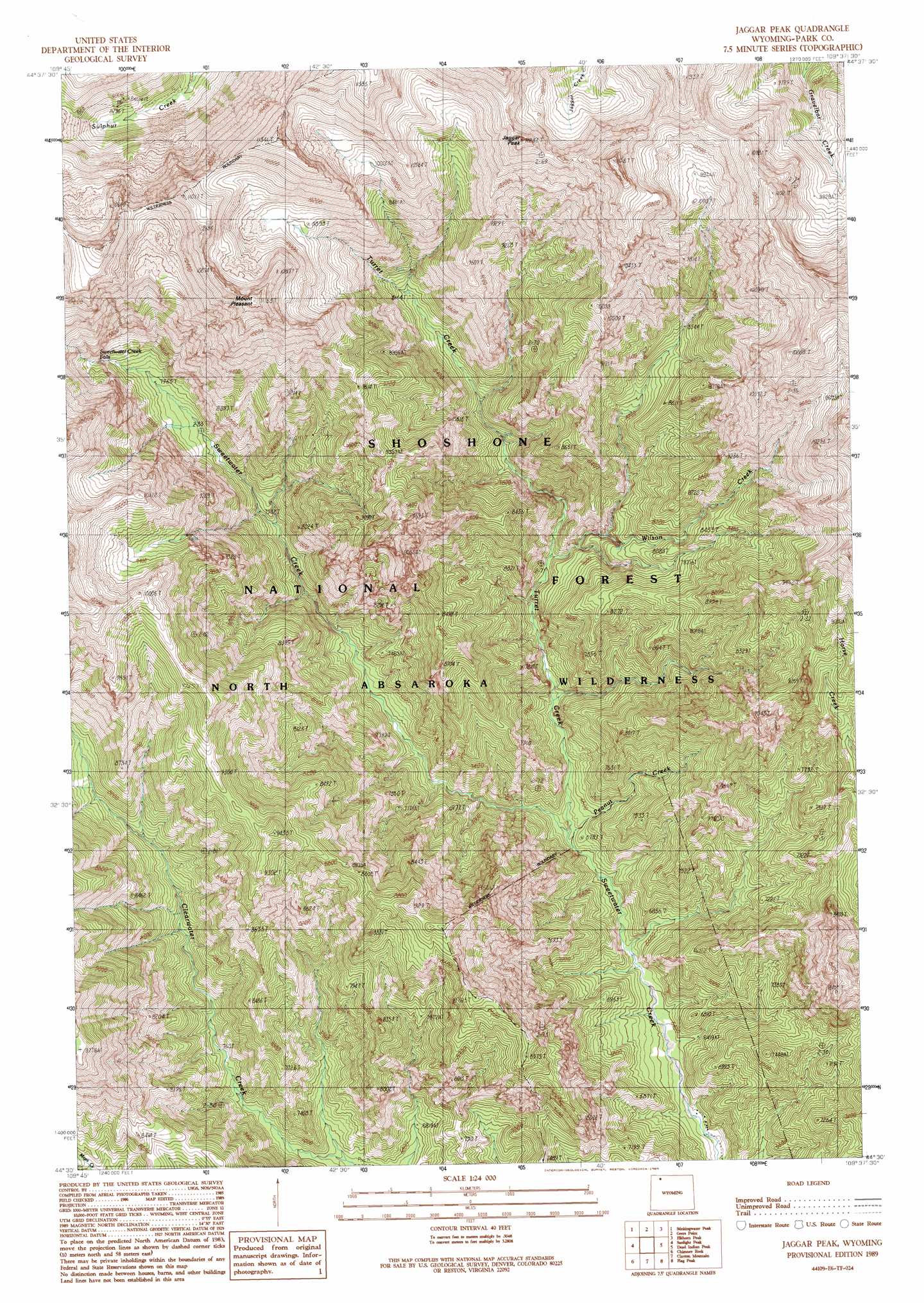
Jaggar Peak Topo Map Wyoming
To zoom in, hover over the map of Jaggar Peak
USGS Topo Quad 44109e6 - 1:24,000 scale
| Topo Map Name: | Jaggar Peak |
| USGS Topo Quad ID: | 44109e6 |
| Print Size: | ca. 21 1/4" wide x 27" high |
| Southeast Coordinates: | 44.5° N latitude / 109.625° W longitude |
| Map Center Coordinates: | 44.5625° N latitude / 109.6875° W longitude |
| U.S. State: | WY |
| Filename: | o44109e6.jpg |
| Download Map JPG Image: | Jaggar Peak topo map 1:24,000 scale |
| Map Type: | Topographic |
| Topo Series: | 7.5´ |
| Map Scale: | 1:24,000 |
| Source of Map Images: | United States Geological Survey (USGS) |
| Alternate Map Versions: |
Jaggar Peak WY 1989, updated 1989 Download PDF Buy paper map Jaggar Peak WY 1991, updated 1997 Download PDF Buy paper map Jaggar Peak WY 2012 Download PDF Buy paper map Jaggar Peak WY 2015 Download PDF Buy paper map |
| FStopo: | US Forest Service topo Jaggar Peak is available: Download FStopo PDF Download FStopo TIF |
1:24,000 Topo Quads surrounding Jaggar Peak
Canoe Lake |
Hurricane Mesa |
Hunter Peak |
Windy Mountain |
Dillworth Bench |
Pollux Peak |
Stinkingwater Peak |
Geers Point |
Elkhorn Peak |
Dead Indian Meadows |
Pahaska Tepee |
Sunlight Peak |
Jaggar Peak |
Dead Indian Peak |
Jim Mountain |
Eagle Creek |
Chimney Rock |
Clayton Mountain |
Flag Peak |
Wapiti |
Pinnacle Mountain |
Sheep Mesa |
Lake Creek |
Ptarmigan Mountain |
Twin Creek |
> Back to 44109e1 at 1:100,000 scale
> Back to 44108a1 at 1:250,000 scale
> Back to U.S. Topo Maps home
Jaggar Peak topo map: Gazetteer
Jaggar Peak: Falls
Sweetwater Creek Falls elevation 2589m 8494′Jaggar Peak: Streams
Peanut Creek elevation 2026m 6646′Turret Creek elevation 2032m 6666′
Wilson Creek elevation 2206m 7237′
Jaggar Peak: Summits
Jaggar Peak elevation 3403m 11164′Mount Pleasant elevation 3399m 11151′
Nipple Mesa elevation 3029m 9937′
Jaggar Peak digital topo map on disk
Buy this Jaggar Peak topo map showing relief, roads, GPS coordinates and other geographical features, as a high-resolution digital map file on DVD: