Pahaska Tepee Topo Map Wyoming
To zoom in, hover over the map of Pahaska Tepee
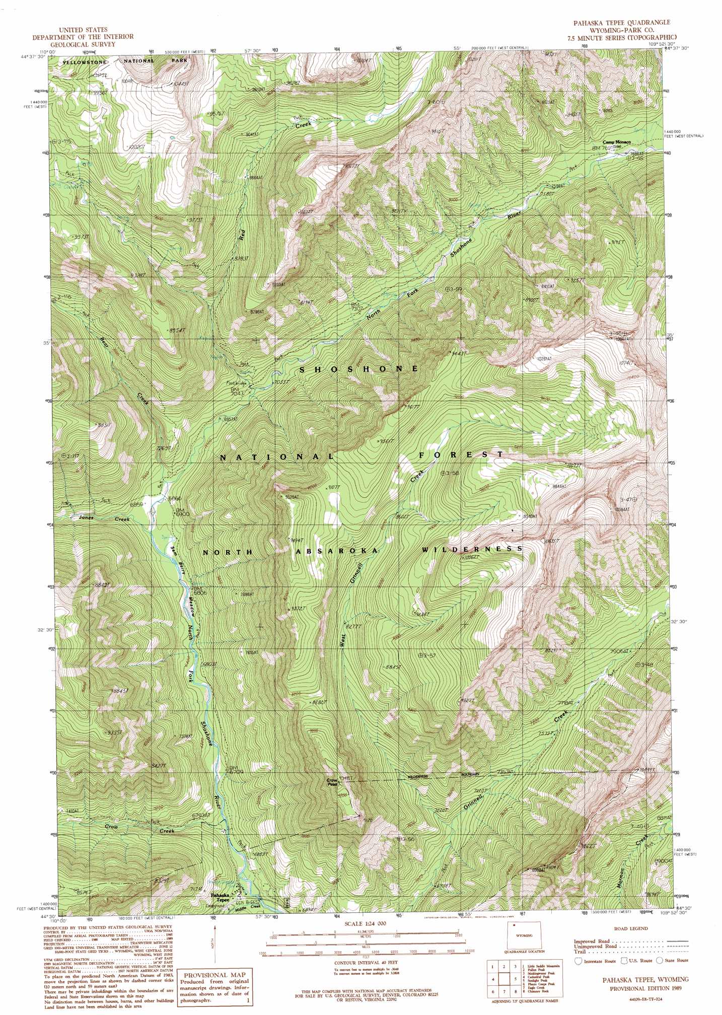
USGS Topo Quad 44109e8 - 1:24,000 scale
| Topo Map Name: | Pahaska Tepee |
| USGS Topo Quad ID: | 44109e8 |
| Print Size: | ca. 21 1/4" wide x 27" high |
| Southeast Coordinates: | 44.5° N latitude / 109.875° W longitude |
| Map Center Coordinates: | 44.5625° N latitude / 109.9375° W longitude |
| U.S. State: | WY |
| Filename: | o44109e8.jpg |
| Download Map JPG Image: | Pahaska Tepee topo map 1:24,000 scale |
| Map Type: | Topographic |
| Topo Series: | 7.5´ |
| Map Scale: | 1:24,000 |
| Source of Map Images: | United States Geological Survey (USGS) |
| Alternate Map Versions: |
Pahaska Tepee WY 1989, updated 1989 Download PDF Buy paper map Pahaska Tepee WY 1991, updated 1997 Download PDF Buy paper map Pahaska Tepee WY 1991, updated 1997 Download PDF Buy paper map Pahaska Tepee WY 2012 Download PDF Buy paper map Pahaska Tepee WY 2015 Download PDF Buy paper map |
| FStopo: | US Forest Service topo Pahaska Tepee is available: Download FStopo PDF Download FStopo TIF |
1:24,000 Topo Quads surrounding Pahaska Tepee
Opal Creek |
Wahb Springs |
Canoe Lake |
Hurricane Mesa |
Hunter Peak |
Pelican Cone |
Little Saddle Mountain |
Pollux Peak |
Stinkingwater Peak |
Geers Point |
Mount Chittenden |
Cathedral Peak |
Pahaska Tepee |
Sunlight Peak |
Jaggar Peak |
Sylvan Lake |
Plenty Coups Peak |
Eagle Creek |
Chimney Rock |
Clayton Mountain |
Trail Lake |
Eagle Peak |
Pinnacle Mountain |
Sheep Mesa |
Lake Creek |
> Back to 44109e1 at 1:100,000 scale
> Back to 44108a1 at 1:250,000 scale
> Back to U.S. Topo Maps home
Pahaska Tepee topo map: Gazetteer
Pahaska Tepee: Flats
Sam Berry Meadow elevation 2083m 6833′Pahaska Tepee: Populated Places
Pahaska Tepee elevation 2034m 6673′Pahaska Tepee: Streams
Bear Creek elevation 2112m 6929′Crow Creek elevation 2056m 6745′
Grinnell Creek elevation 2228m 7309′
Jones Creek elevation 2079m 6820′
Middle Creek elevation 2027m 6650′
Red Creek elevation 2148m 7047′
West Grinnell Creek elevation 2147m 7043′
Pahaska Tepee: Summits
Crow Peak elevation 2697m 8848′Pahaska Tepee: Trails
Pahaska Sunlight Trail elevation 2151m 7057′Pahaska Tepee digital topo map on disk
Buy this Pahaska Tepee topo map showing relief, roads, GPS coordinates and other geographical features, as a high-resolution digital map file on DVD: