Beartooth Butte Topo Map Wyoming
To zoom in, hover over the map of Beartooth Butte
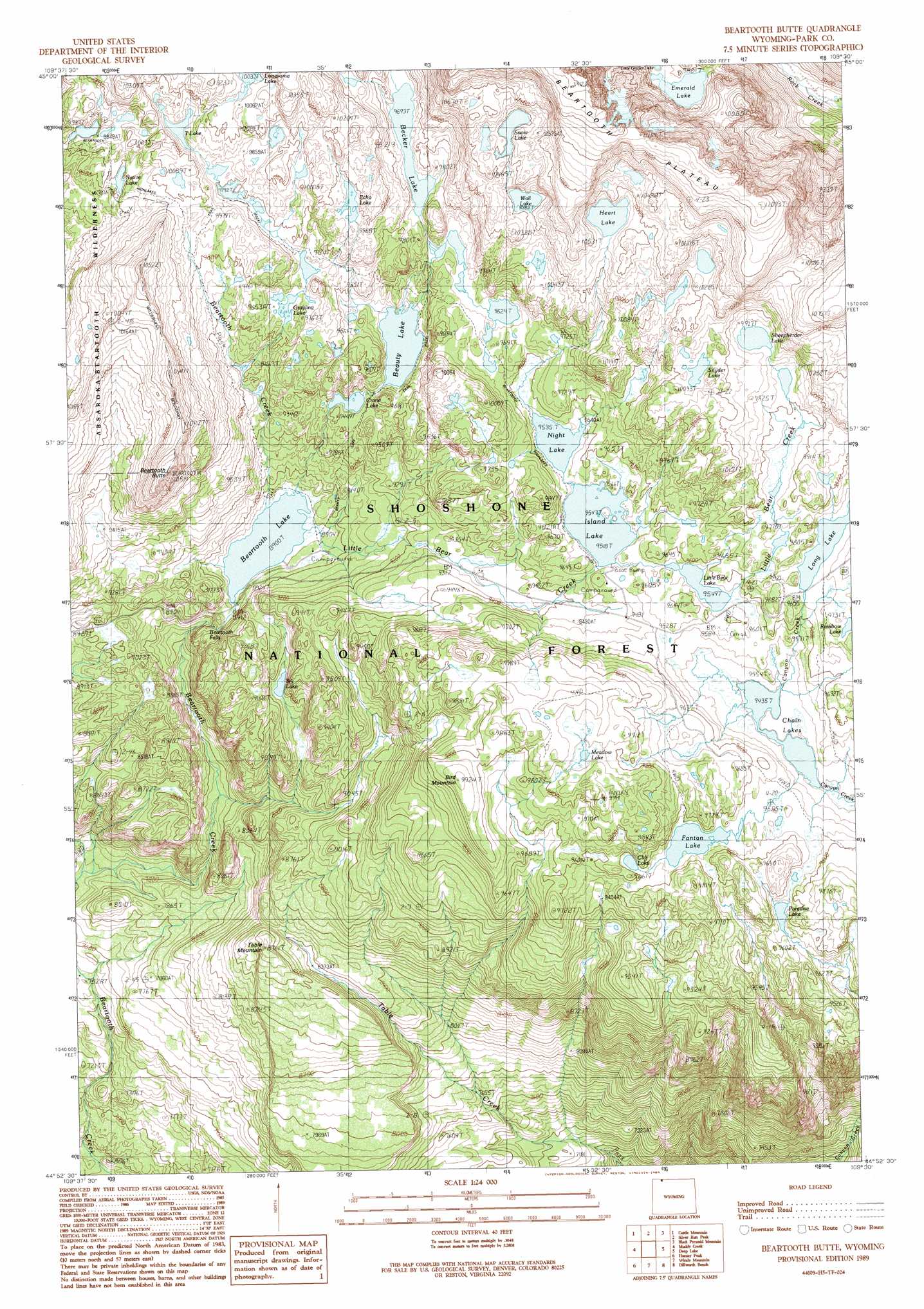
USGS Topo Quad 44109h5 - 1:24,000 scale
| Topo Map Name: | Beartooth Butte |
| USGS Topo Quad ID: | 44109h5 |
| Print Size: | ca. 21 1/4" wide x 27" high |
| Southeast Coordinates: | 44.875° N latitude / 109.5° W longitude |
| Map Center Coordinates: | 44.9375° N latitude / 109.5625° W longitude |
| U.S. State: | WY |
| Filename: | o44109h5.jpg |
| Download Map JPG Image: | Beartooth Butte topo map 1:24,000 scale |
| Map Type: | Topographic |
| Topo Series: | 7.5´ |
| Map Scale: | 1:24,000 |
| Source of Map Images: | United States Geological Survey (USGS) |
| Alternate Map Versions: |
Beartooth Butte WY 1989, updated 1989 Download PDF Buy paper map Beartooth Butte WY 1989, updated 1989 Download PDF Buy paper map Beartooth Butte WY 1991, updated 1996 Download PDF Buy paper map Beartooth Butte WY 2012 Download PDF Buy paper map Beartooth Butte WY 2015 Download PDF Buy paper map |
| FStopo: | US Forest Service topo Beartooth Butte is available: Download FStopo PDF Download FStopo TIF |
1:24,000 Topo Quads surrounding Beartooth Butte
Granite Peak |
Alpine |
Sylvan Peak |
Bare Mountain |
Red Lodge West |
Fossil Lake |
Castle Mountain |
Silver Run Peak |
Black Pyramid Mountain |
Mount Maurice |
Jim Smith Peak |
Muddy Creek |
Beartooth Butte |
Deep Lake |
North Bennett Creek |
Hurricane Mesa |
Hunter Peak |
Windy Mountain |
Dillworth Bench |
Bald Peak |
Stinkingwater Peak |
Geers Point |
Elkhorn Peak |
Dead Indian Meadows |
Pat O' Hara Mountain |
> Back to 44109e1 at 1:100,000 scale
> Back to 44108a1 at 1:250,000 scale
> Back to U.S. Topo Maps home
Beartooth Butte topo map: Gazetteer
Beartooth Butte: Areas
Beartooth Plateau elevation 3376m 11076′Beartooth Butte: Falls
Beartooth Falls elevation 2662m 8733′Beartooth Butte: Lakes
Beartooth Lake elevation 2716m 8910′Beauty Lake elevation 2878m 9442′
Becker Lake elevation 2961m 9714′
Chain Lakes elevation 2878m 9442′
Cliff Lake elevation 2923m 9589′
Crane Lake elevation 2851m 9353′
Echo Lake elevation 3041m 9977′
Emerald Lake elevation 2974m 9757′
Fantan Lake elevation 2913m 9557′
Grayling Lake elevation 2948m 9671′
Heart Lake elevation 3144m 10314′
Island Lake elevation 2902m 9520′
Little Bear Lake elevation 2913m 9557′
Lonesome Lake elevation 3059m 10036′
Long Lake elevation 2946m 9665′
Meadow Lake elevation 2997m 9832′
Native Lake elevation 2984m 9790′
Night Lake elevation 2913m 9557′
Paradise Lake elevation 2902m 9520′
Sheepherder Lake elevation 3021m 9911′
Sill Lake elevation 2730m 8956′
Snow Lake elevation 3170m 10400′
Snyder Lake elevation 3058m 10032′
T Lake elevation 3012m 9881′
Wall Lake elevation 3108m 10196′
Beartooth Butte: Plains
Beartooth Plateau elevation 2990m 9809′Beartooth Butte: Streams
Little Bear Creek elevation 2716m 8910′Beartooth Butte: Summits
Beartooth Butte elevation 3195m 10482′Bird Mountain elevation 3027m 9931′
Table Mountain elevation 2620m 8595′
Beartooth Butte: Trails
Beartooth Highlakes Trail elevation 2977m 9767′Beauty Lake Trail elevation 2866m 9402′
Beartooth Butte digital topo map on disk
Buy this Beartooth Butte topo map showing relief, roads, GPS coordinates and other geographical features, as a high-resolution digital map file on DVD: