Snake Hot Springs Topo Map Wyoming
To zoom in, hover over the map of Snake Hot Springs
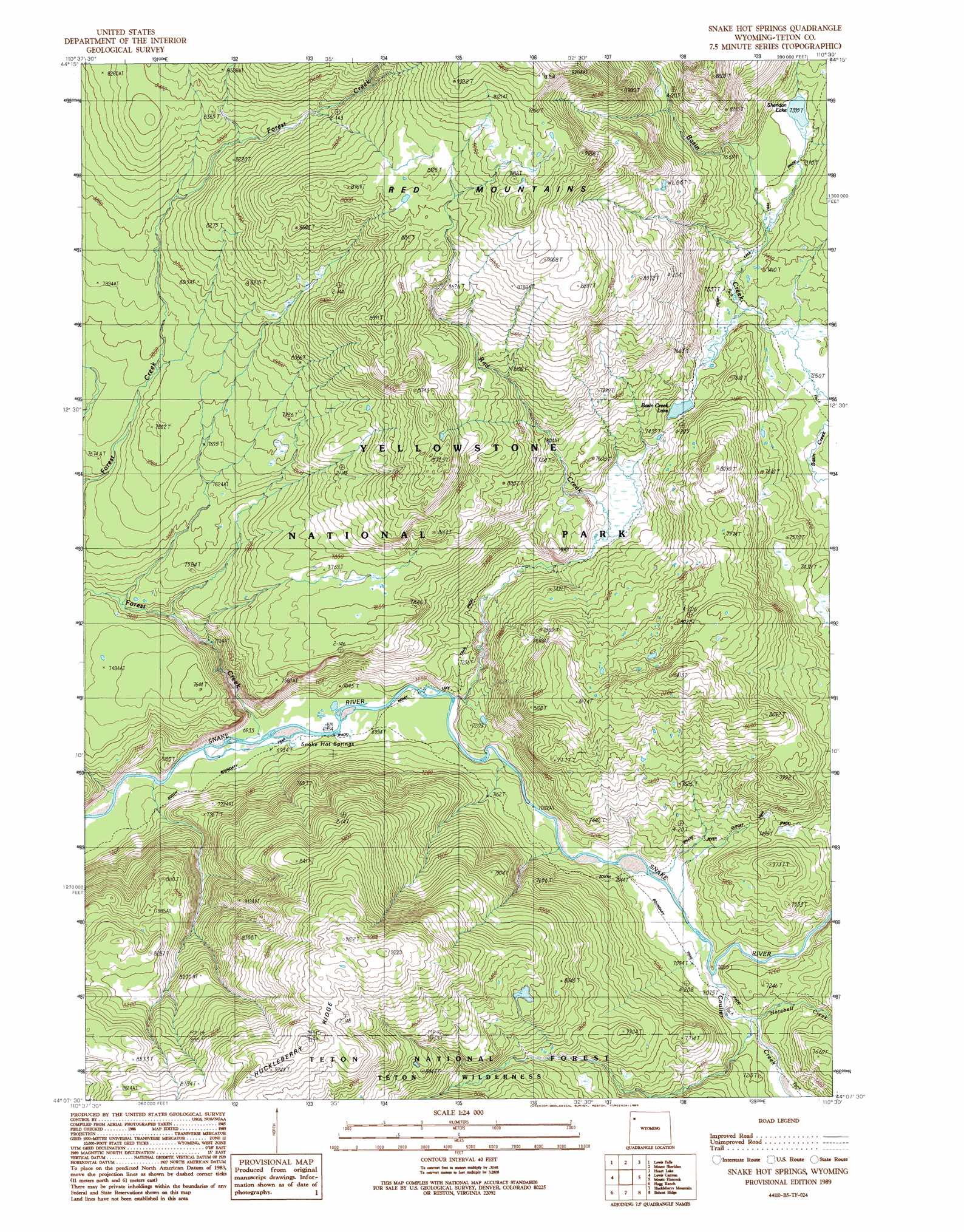
USGS Topo Quad 44110b5 - 1:24,000 scale
| Topo Map Name: | Snake Hot Springs |
| USGS Topo Quad ID: | 44110b5 |
| Print Size: | ca. 21 1/4" wide x 27" high |
| Southeast Coordinates: | 44.125° N latitude / 110.5° W longitude |
| Map Center Coordinates: | 44.1875° N latitude / 110.5625° W longitude |
| U.S. State: | WY |
| Filename: | o44110b5.jpg |
| Download Map JPG Image: | Snake Hot Springs topo map 1:24,000 scale |
| Map Type: | Topographic |
| Topo Series: | 7.5´ |
| Map Scale: | 1:24,000 |
| Source of Map Images: | United States Geological Survey (USGS) |
| Alternate Map Versions: |
Snake Hot Springs WY 1989, updated 1989 Download PDF Buy paper map Snake Hot Springs WY 1996, updated 1998 Download PDF Buy paper map Snake Hot Springs WY 2012 Download PDF Buy paper map Snake Hot Springs WY 2015 Download PDF Buy paper map |
| FStopo: | US Forest Service topo Snake Hot Springs is available: Download FStopo PDF Download FStopo TIF |
1:24,000 Topo Quads surrounding Snake Hot Springs
Old Faithful |
Craig Pass |
West Thumb |
Dot Island |
Frank Island |
Shoshone Geyser Basin |
Lewis Falls |
Mount Sheridan |
Heart Lake |
Alder Lake |
Grassy Lake Reservoir |
Lewis Canyon |
Snake Hot Springs |
Mount Hancock |
Crooked Creek |
Survey Peak |
Flagg Ranch |
Huckleberry Mountain |
Bobcat Ridge |
Gravel Peak |
Ranger Peak |
Colter Bay |
Two Ocean Lake |
Whetstone Mountain |
Hunter Mountain |
> Back to 44110a1 at 1:100,000 scale
> Back to 44110a1 at 1:250,000 scale
> Back to U.S. Topo Maps home
Snake Hot Springs topo map: Gazetteer
Snake Hot Springs: Lakes
Basin Creek Lake elevation 2253m 7391′Sheridan Lake elevation 2255m 7398′
Snake Hot Springs: Springs
Snake Hot Springs elevation 2118m 6948′Snake Hot Springs: Streams
Coulter Creek elevation 2159m 7083′Forest Creek elevation 2113m 6932′
Harebell Creek elevation 2170m 7119′
Red Creek elevation 2132m 6994′
Snake Hot Springs: Trails
Harebell Trail elevation 2217m 7273′South Boundary Trail elevation 2127m 6978′
Snake Hot Springs digital topo map on disk
Buy this Snake Hot Springs topo map showing relief, roads, GPS coordinates and other geographical features, as a high-resolution digital map file on DVD: