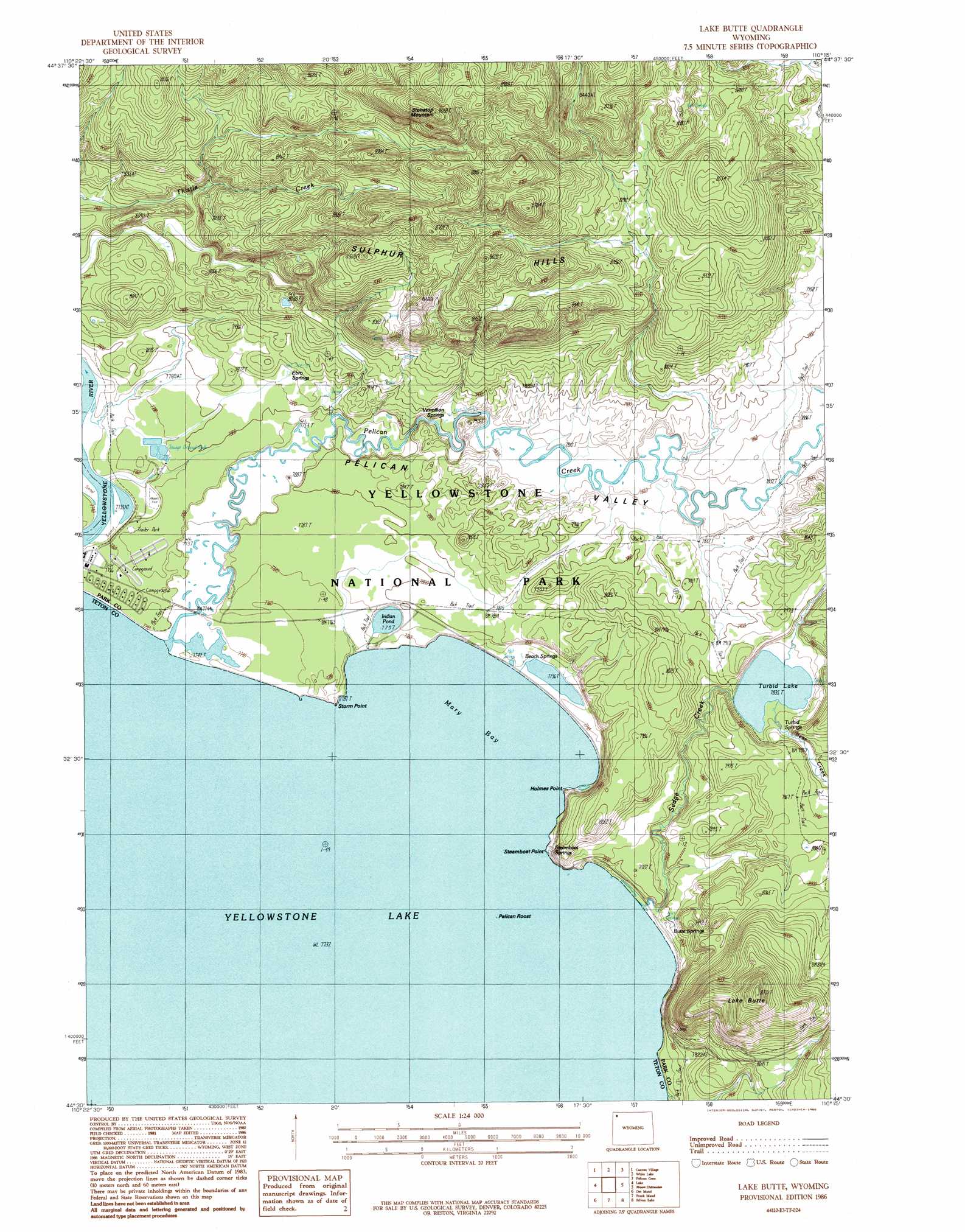
Lake Butte Topo Map Wyoming
To zoom in, hover over the map of Lake Butte
USGS Topo Quad 44110e3 - 1:24,000 scale
| Topo Map Name: | Lake Butte |
| USGS Topo Quad ID: | 44110e3 |
| Print Size: | ca. 21 1/4" wide x 27" high |
| Southeast Coordinates: | 44.5° N latitude / 110.25° W longitude |
| Map Center Coordinates: | 44.5625° N latitude / 110.3125° W longitude |
| U.S. State: | WY |
| Filename: | o44110e3.jpg |
| Download Map JPG Image: | Lake Butte topo map 1:24,000 scale |
| Map Type: | Topographic |
| Topo Series: | 7.5´ |
| Map Scale: | 1:24,000 |
| Source of Map Images: | United States Geological Survey (USGS) |
| Alternate Map Versions: |
Lake Butte WY 1986, updated 1986 Download PDF Buy paper map Lake Butte WY 2012 Download PDF Buy paper map Lake Butte WY 2015 Download PDF Buy paper map |
1:24,000 Topo Quads surrounding Lake Butte
Cook Peak |
Mount Washburn |
Amethyst Mountain |
Opal Creek |
Wahb Springs |
Crystal Falls |
Canyon Village |
White Lake |
Pelican Cone |
Little Saddle Mountain |
Beach Lake |
Lake |
Lake Butte |
Mount Chittenden |
Cathedral Peak |
West Thumb |
Dot Island |
Frank Island |
Sylvan Lake |
Plenty Coups Peak |
Mount Sheridan |
Heart Lake |
Alder Lake |
Trail Lake |
Eagle Peak |
> Back to 44110e1 at 1:100,000 scale
> Back to 44110a1 at 1:250,000 scale
> Back to U.S. Topo Maps home
Lake Butte topo map: Gazetteer
Lake Butte: Bays
Mary Bay elevation 2358m 7736′Lake Butte: Cliffs
Holmes Point elevation 2358m 7736′Steamboat Point elevation 2358m 7736′
Storm Point elevation 2364m 7755′
Lake Butte: Islands
Pelican Roost elevation 2358m 7736′Lake Butte: Lakes
Indian Pond elevation 2366m 7762′Turbid Lake elevation 2389m 7837′
Lake Butte: Springs
Beach Springs elevation 2363m 7752′Butte Spring elevation 2374m 7788′
Butte Springs elevation 2402m 7880′
Butte Springs elevation 2376m 7795′
Ebro Springs elevation 2388m 7834′
Steamboat Springs elevation 2377m 7798′
Turbid Springs elevation 2404m 7887′
Vermilion Springs elevation 2389m 7837′
Vermilion Springs elevation 2381m 7811′
Lake Butte: Streams
Bear Creek elevation 2391m 7844′Pelican Creek elevation 2358m 7736′
Sedge Creek elevation 2358m 7736′
Lake Butte: Summits
Lake Butte elevation 2661m 8730′Stonetop Mountain elevation 2750m 9022′
Sulphur Hills elevation 2555m 8382′
Lake Butte: Trails
Pelican Creek Trail elevation 2404m 7887′Lake Butte: Valleys
Pelican Valley elevation 2359m 7739′Lake Butte digital topo map on disk
Buy this Lake Butte topo map showing relief, roads, GPS coordinates and other geographical features, as a high-resolution digital map file on DVD: