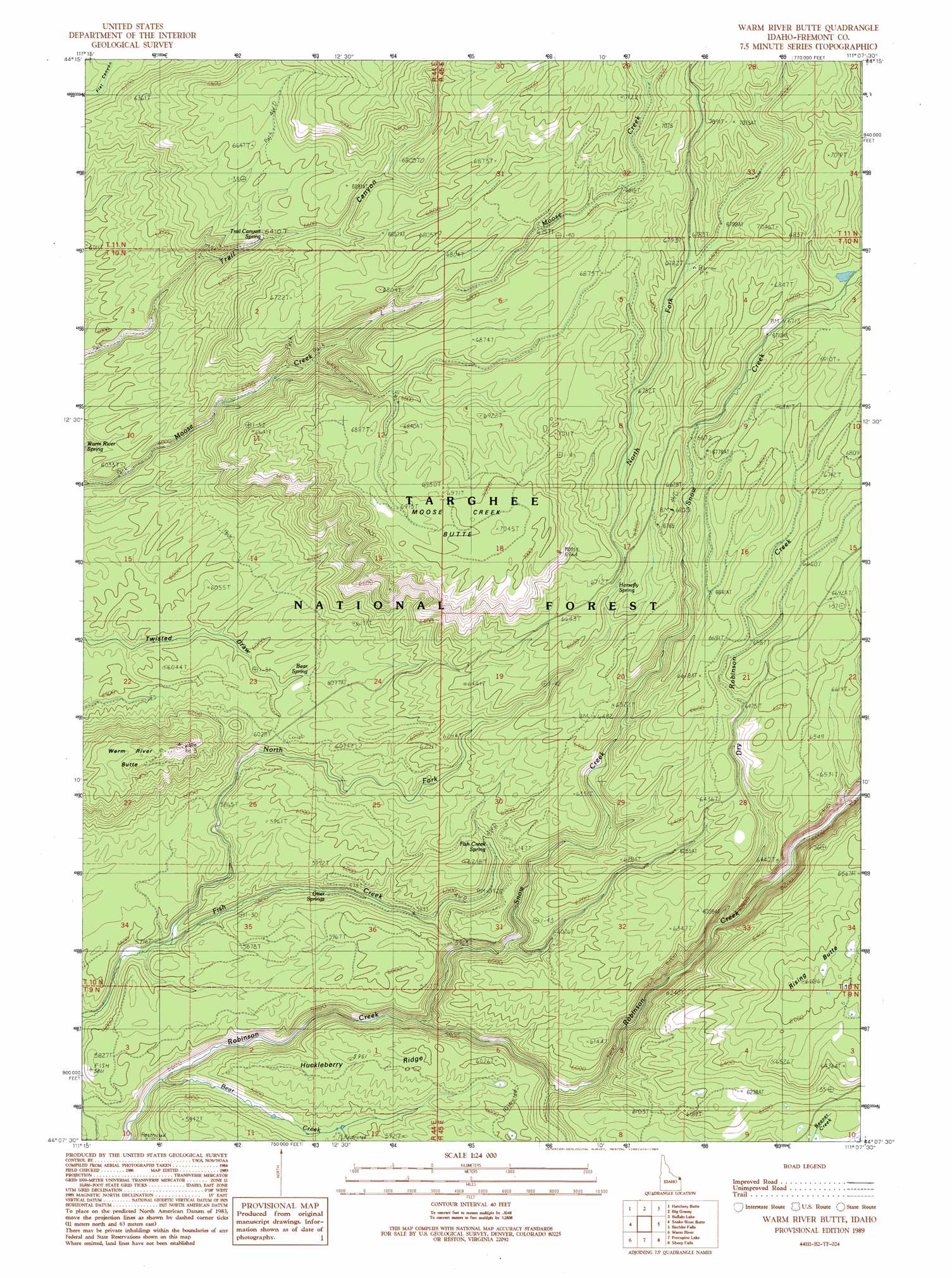
Warm River Butte Topo Map Idaho
To zoom in, hover over the map of Warm River Butte
USGS Topo Quad 44111b2 - 1:24,000 scale
| Topo Map Name: | Warm River Butte |
| USGS Topo Quad ID: | 44111b2 |
| Print Size: | ca. 21 1/4" wide x 27" high |
| Southeast Coordinates: | 44.125° N latitude / 111.125° W longitude |
| Map Center Coordinates: | 44.1875° N latitude / 111.1875° W longitude |
| U.S. State: | ID |
| Filename: | o44111b2.jpg |
| Download Map JPG Image: | Warm River Butte topo map 1:24,000 scale |
| Map Type: | Topographic |
| Topo Series: | 7.5´ |
| Map Scale: | 1:24,000 |
| Source of Map Images: | United States Geological Survey (USGS) |
| Alternate Map Versions: |
Warm River Butte ID 1989, updated 1989 Download PDF Buy paper map Warm River Butte ID 2011 Download PDF Buy paper map Warm River Butte ID 2013 Download PDF Buy paper map |
| FStopo: | US Forest Service topo Warm River Butte is available: Download FStopo PDF Download FStopo TIF |
1:24,000 Topo Quads surrounding Warm River Butte
Island Park Dam |
Island Park |
Latham Spring |
Buffalo Lake Ne |
Summit Lake |
Last Chance |
Hatchery Butte |
Big Grassy |
Buffalo Lake |
Trischman Knob |
Lookout Butte |
Snake River Butte |
Warm River Butte |
Bechler Falls |
Cave Falls |
Ashton |
Warm River |
Porcupine Lake |
Sheep Falls |
Hominy Peak |
Linderman Dam |
Drummond |
Lamont |
Mcrenolds Reservoir |
Rammel Mountain |
> Back to 44111a1 at 1:100,000 scale
> Back to 44110a1 at 1:250,000 scale
> Back to U.S. Topo Maps home
Warm River Butte topo map: Gazetteer
Warm River Butte: Ridges
Huckleberry Ridge elevation 1796m 5892′Warm River Butte: Springs
Bear Spring elevation 1846m 6056′Fish Creek Spring elevation 1853m 6079′
Horsefly Spring elevation 2058m 6751′
Otter Springs elevation 1786m 5859′
Trail Canyon Spring elevation 2036m 6679′
Warm River Butte: Streams
Bear Creek elevation 1725m 5659′Dry Robinson Creek elevation 1785m 5856′
North Fork Fish Creek elevation 1712m 5616′
Snow Creek elevation 1750m 5741′
Warm River Butte: Summits
Moose Creek Butte elevation 2135m 7004′Rising Butte elevation 2030m 6660′
Warm River Butte elevation 1882m 6174′
Warm River Butte digital topo map on disk
Buy this Warm River Butte topo map showing relief, roads, GPS coordinates and other geographical features, as a high-resolution digital map file on DVD: