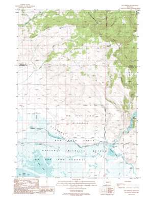
Elk Springs Topo Map Montana
To zoom in, hover over the map of Elk Springs
USGS Topo Quad 44111f6 - 1:24,000 scale
| Topo Map Name: | Elk Springs |
| USGS Topo Quad ID: | 44111f6 |
| Print Size: | ca. 21 1/4" wide x 27" high |
| Southeast Coordinates: | 44.625° N latitude / 111.625° W longitude |
| Map Center Coordinates: | 44.6875° N latitude / 111.6875° W longitude |
| U.S. State: | MT |
| Filename: | o44111f6.jpg |
| Download Map JPG Image: | Elk Springs topo map 1:24,000 scale |
| Map Type: | Topographic |
| Topo Series: | 7.5´ |
| Map Scale: | 1:24,000 |
| Source of Map Images: | United States Geological Survey (USGS) |
| Alternate Map Versions: |
Elk Springs MT 1988, updated 1988 Download PDF Buy paper map Elk Springs MT 1997, updated 2002 Download PDF Buy paper map Elk Springs MT 2011 Download PDF Buy paper map Elk Springs MT 2014 Download PDF Buy paper map |
| FStopo: | US Forest Service topo Elk Springs is available: Download FStopo PDF Download FStopo TIF |
1:24,000 Topo Quads surrounding Elk Springs
> Back to 44111e1 at 1:100,000 scale
> Back to 44110a1 at 1:250,000 scale
> Back to U.S. Topo Maps home
Elk Springs topo map: Gazetteer
Elk Springs: Channels
The Narrows elevation 2035m 6676′Elk Springs: Dams
Culver Springs Dam elevation 2034m 6673′Widgeon Pond Dam elevation 2026m 6646′
Elk Springs: Gaps
Hoodoo Pass elevation 2289m 7509′Snowshoe Pass elevation 2301m 7549′
Elk Springs: Lakes
Antelope Pond elevation 2018m 6620′MacDonald Pond elevation 2024m 6640′
Swan Lake elevation 2016m 6614′
Widgeon Pond elevation 2025m 6643′
Elk Springs: Reservoirs
Widgeon Pond elevation 2026m 6646′Elk Springs: Springs
13S01E29CAB_01 Spring elevation 2045m 6709′13S01E31DCAB01 Spring elevation 2028m 6653′
13S01W04DCC_01 Spring elevation 2205m 7234′
13S01W10BBA_01 Spring elevation 2268m 7440′
13S01W12DAAC01 Spring elevation 2350m 7709′
Culver Springs elevation 2037m 6683′
Elk Springs elevation 2035m 6676′
Two Drink Springs elevation 2440m 8005′
Elk Springs: Streams
Hackett Creek elevation 2024m 6640′Horse Creek elevation 2037m 6683′
Lobo Creek elevation 2086m 6843′
Narrows Creek elevation 2035m 6676′
Elk Springs: Wells
13S01W27BBAC01 Well elevation 2046m 6712′13S01W28BCBB01 Well elevation 2032m 6666′
13S01W28DDD_01 Well elevation 2030m 6660′
Elk Springs digital topo map on disk
Buy this Elk Springs topo map showing relief, roads, GPS coordinates and other geographical features, as a high-resolution digital map file on DVD:


