Hebgen Dam Topo Map Montana
To zoom in, hover over the map of Hebgen Dam
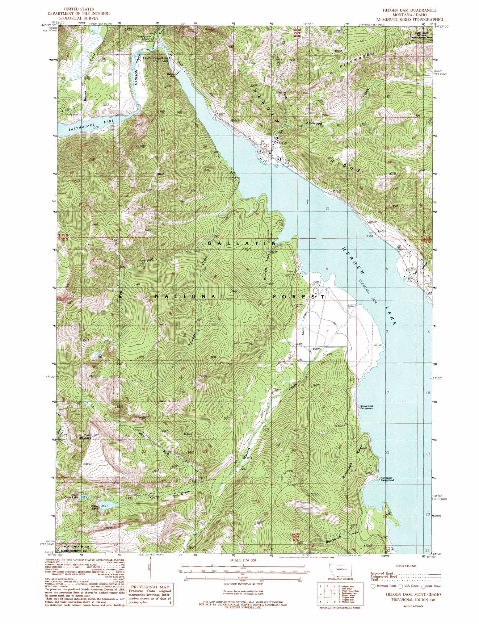
USGS Topo Quad 44111g3 - 1:24,000 scale
| Topo Map Name: | Hebgen Dam |
| USGS Topo Quad ID: | 44111g3 |
| Print Size: | ca. 21 1/4" wide x 27" high |
| Southeast Coordinates: | 44.75° N latitude / 111.25° W longitude |
| Map Center Coordinates: | 44.8125° N latitude / 111.3125° W longitude |
| U.S. States: | MT, ID |
| Filename: | o44111g3.jpg |
| Download Map JPG Image: | Hebgen Dam topo map 1:24,000 scale |
| Map Type: | Topographic |
| Topo Series: | 7.5´ |
| Map Scale: | 1:24,000 |
| Source of Map Images: | United States Geological Survey (USGS) |
| Alternate Map Versions: |
Hebgen Dam MT 1988, updated 1989 Download PDF Buy paper map Hebgen Dam MT 2000, updated 2005 Download PDF Buy paper map Hebgen Dam MT 2011 Download PDF Buy paper map Hebgen Dam MT 2014 Download PDF Buy paper map |
| FStopo: | US Forest Service topo Hebgen Dam is available: Download FStopo PDF Download FStopo TIF |
1:24,000 Topo Quads surrounding Hebgen Dam
No Man Peak |
Koch Peak |
Lincoln Mountain |
Sunshine Point |
Big Horn Peak |
Squaw Creek |
Hilgard Peak |
Pika Point |
Upper Tepee Basin |
Divide Lake |
Cliff Lake |
Earthquake Lake |
Hebgen Dam |
Mount Hebgen |
Richards Creek |
Hidden Lake Bench |
Targhee Peak |
Targhee Pass |
Madison Arm |
West Yellowstone |
Mount Jefferson |
Sawtell Peak |
Big Springs |
Reas Pass |
Jack Straw Basin |
> Back to 44111e1 at 1:100,000 scale
> Back to 44110a1 at 1:250,000 scale
> Back to U.S. Topo Maps home
Hebgen Dam topo map: Gazetteer
Hebgen Dam: Canals
Ruof Ditch elevation 2009m 6591′Hebgen Dam: Dams
Hebgen Dam elevation 1992m 6535′Hebgen Dam: Lakes
Coffin Lake elevation 2568m 8425′Upper Coffin Lake elevation 2670m 8759′
Hebgen Dam: Reservoirs
Hebgen Lake elevation 1993m 6538′Hebgen Reservoir elevation 1973m 6473′
Hebgen Dam: Ridges
Hebgen Ridge elevation 2326m 7631′Rumbaugh Ridge elevation 2072m 6797′
Hebgen Dam: Streams
Beaver Creek elevation 1948m 6391′Cabin Creek elevation 1969m 6459′
Coffin Creek elevation 2226m 7303′
Dave Johnson Creek elevation 1993m 6538′
Kirkwood Creek elevation 1993m 6538′
Moonlight Creek elevation 1993m 6538′
North Fork Kirkwood Creek elevation 2079m 6820′
Rumbaugh Creek elevation 1993m 6538′
Trapper Creek elevation 1993m 6538′
Wally McClure Creek elevation 2021m 6630′
Watkins Creek elevation 1993m 6538′
West Fork Trapper Creek elevation 2071m 6794′
West Fork Watkins Creek elevation 2199m 7214′
Hebgen Dam: Summits
Coffin Mountain elevation 3038m 9967′Hebgen Dam: Wells
12S04E05ADDC01 Well elevation 2009m 6591′Hebgen Dam digital topo map on disk
Buy this Hebgen Dam topo map showing relief, roads, GPS coordinates and other geographical features, as a high-resolution digital map file on DVD: