Freezeout Mountain Topo Map Montana
To zoom in, hover over the map of Freezeout Mountain
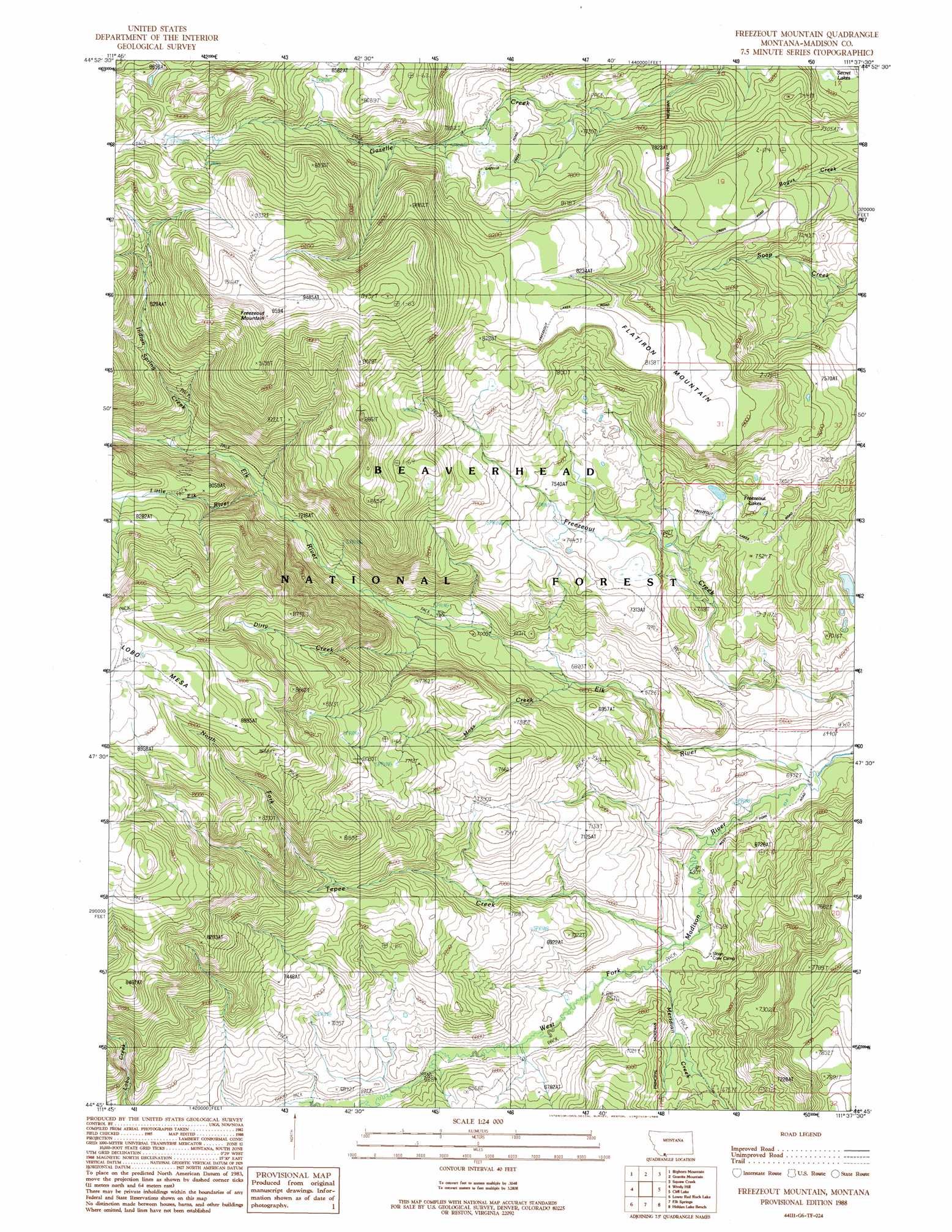
USGS Topo Quad 44111g6 - 1:24,000 scale
| Topo Map Name: | Freezeout Mountain |
| USGS Topo Quad ID: | 44111g6 |
| Print Size: | ca. 21 1/4" wide x 27" high |
| Southeast Coordinates: | 44.75° N latitude / 111.625° W longitude |
| Map Center Coordinates: | 44.8125° N latitude / 111.6875° W longitude |
| U.S. State: | MT |
| Filename: | o44111g6.jpg |
| Download Map JPG Image: | Freezeout Mountain topo map 1:24,000 scale |
| Map Type: | Topographic |
| Topo Series: | 7.5´ |
| Map Scale: | 1:24,000 |
| Source of Map Images: | United States Geological Survey (USGS) |
| Alternate Map Versions: |
Freezeout Mountain MT 1988, updated 1988 Download PDF Buy paper map Freezeout Mountain MT 1997, updated 2002 Download PDF Buy paper map Freezeout Mountain MT 2011 Download PDF Buy paper map Freezeout Mountain MT 2014 Download PDF Buy paper map |
| FStopo: | US Forest Service topo Freezeout Mountain is available: Download FStopo PDF Download FStopo TIF |
1:24,000 Topo Quads surrounding Freezeout Mountain
Warm Springs Creek |
Broomtail Ridge |
Bucks Nest |
No Man Peak |
Koch Peak |
Iron Creek |
Bighorn Mountain |
Granite Mountain |
Squaw Creek |
Hilgard Peak |
Eureka Basin |
Windy Hill |
Freezeout Mountain |
Cliff Lake |
Earthquake Lake |
Metzel Creek |
Lower Red Rock Lake |
Elk Springs |
Hidden Lake Bench |
Targhee Peak |
Winslow Creek |
Slide Mountain |
Upper Red Rock Lake |
Mount Jefferson |
Sawtell Peak |
> Back to 44111e1 at 1:100,000 scale
> Back to 44110a1 at 1:250,000 scale
> Back to U.S. Topo Maps home
Freezeout Mountain topo map: Gazetteer
Freezeout Mountain: Lakes
Freezeout Lakes elevation 2242m 7355′Freezeout Mountain: Streams
Dirty Creek elevation 2146m 7040′Elk River elevation 1971m 6466′
Indian Spring Creek elevation 2258m 7408′
Little Elk River elevation 2249m 7378′
Meridian Creek elevation 2001m 6564′
Moss Creek elevation 2075m 6807′
North Fork Tepee Creek elevation 2292m 7519′
Tepee Creek elevation 2001m 6564′
Freezeout Mountain: Summits
Flatiron Mountain elevation 2470m 8103′Freezeout Mountain elevation 2922m 9586′
Freezeout Mountain: Swamps
Miller Flats elevation 1958m 6423′Freezeout Mountain digital topo map on disk
Buy this Freezeout Mountain topo map showing relief, roads, GPS coordinates and other geographical features, as a high-resolution digital map file on DVD: