Paul Reservoir Topo Map Idaho
To zoom in, hover over the map of Paul Reservoir
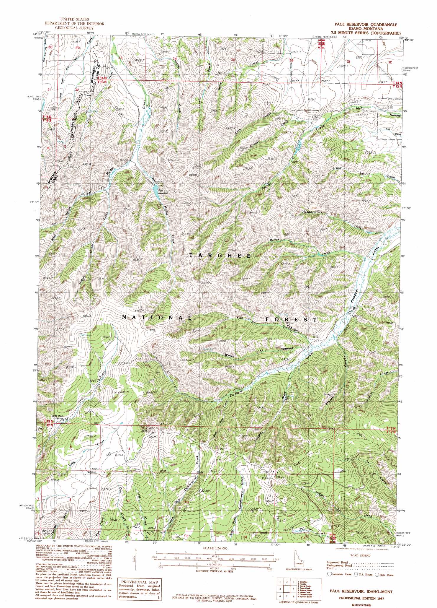
USGS Topo Quad 44112d3 - 1:24,000 scale
| Topo Map Name: | Paul Reservoir |
| USGS Topo Quad ID: | 44112d3 |
| Print Size: | ca. 21 1/4" wide x 27" high |
| Southeast Coordinates: | 44.375° N latitude / 112.25° W longitude |
| Map Center Coordinates: | 44.4375° N latitude / 112.3125° W longitude |
| U.S. States: | ID, MT |
| Filename: | o44112d3.jpg |
| Download Map JPG Image: | Paul Reservoir topo map 1:24,000 scale |
| Map Type: | Topographic |
| Topo Series: | 7.5´ |
| Map Scale: | 1:24,000 |
| Source of Map Images: | United States Geological Survey (USGS) |
| Alternate Map Versions: |
Paul Reservoir ID 1987, updated 1987 Download PDF Buy paper map Paul Reservoir ID 2011 Download PDF Buy paper map Paul Reservoir ID 2013 Download PDF Buy paper map |
| FStopo: | US Forest Service topo Paul Reservoir is available: Download FStopo PDF Download FStopo TIF |
1:24,000 Topo Quads surrounding Paul Reservoir
Lima |
Henry Gulch |
Lima Dam |
Wolverine Creek |
Antelope Peak |
Lima Peaks |
Snowline |
Monida |
Corral Creek |
Big Table Mountain |
Edie Creek |
Tepee Draw |
Paul Reservoir |
Spencer North |
Lookout Point |
Rocky Creek |
Indian Creek |
Thunder Gulch |
Spencer South |
Gardner Lake |
Lidy Hot Springs |
Small |
Lone Butte |
Dubois |
Dubois Ne |
> Back to 44112a1 at 1:100,000 scale
> Back to 44112a1 at 1:250,000 scale
> Back to U.S. Topo Maps home
Paul Reservoir topo map: Gazetteer
Paul Reservoir: Dams
Paul Dam elevation 2319m 7608′Paul Reservoir: Reservoirs
Paul Reservoir elevation 2319m 7608′Paul Reservoir: Springs
Lone Pine Spring elevation 2479m 8133′Paul Reservoir: Streams
Bear Pen Creek elevation 2207m 7240′Ditch Creek elevation 2091m 6860′
East Modoc Creek elevation 2277m 7470′
Grouse Creek elevation 2121m 6958′
Headquarters Creek elevation 2000m 6561′
Horse Creek elevation 2205m 7234′
Middle Modoc Creek elevation 2315m 7595′
Ramshorn Creek elevation 2019m 6624′
West Modoc Creek elevation 2314m 7591′
Paul Reservoir: Trails
Stoddard Creek Trail elevation 2208m 7244′Paul Reservoir: Valleys
Brooks Canyon elevation 2078m 6817′Kite Canyon elevation 2096m 6876′
Swampy Draw elevation 2116m 6942′
White Pine Canyon elevation 2097m 6879′
Paul Reservoir digital topo map on disk
Buy this Paul Reservoir topo map showing relief, roads, GPS coordinates and other geographical features, as a high-resolution digital map file on DVD: