Big Table Mountain Topo Map Montana
To zoom in, hover over the map of Big Table Mountain
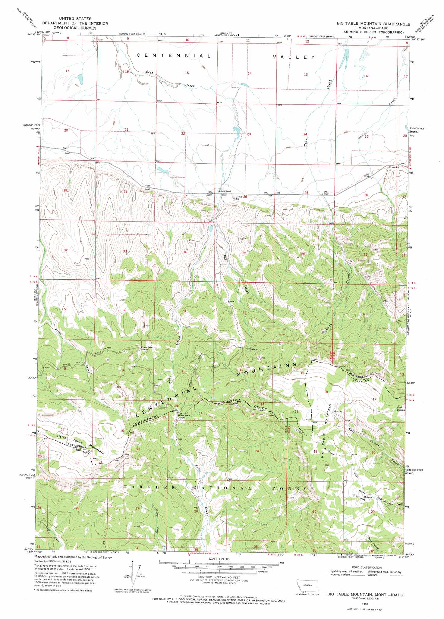
USGS Topo Quad 44112e1 - 1:24,000 scale
| Topo Map Name: | Big Table Mountain |
| USGS Topo Quad ID: | 44112e1 |
| Print Size: | ca. 21 1/4" wide x 27" high |
| Southeast Coordinates: | 44.5° N latitude / 112° W longitude |
| Map Center Coordinates: | 44.5625° N latitude / 112.0625° W longitude |
| U.S. States: | MT, ID |
| Filename: | o44112e1.jpg |
| Download Map JPG Image: | Big Table Mountain topo map 1:24,000 scale |
| Map Type: | Topographic |
| Topo Series: | 7.5´ |
| Map Scale: | 1:24,000 |
| Source of Map Images: | United States Geological Survey (USGS) |
| Alternate Map Versions: |
Big Table Mountain ID 1968, updated 1972 Download PDF Buy paper map Big Table Mountain ID 1968, updated 1984 Download PDF Buy paper map Big Table Mountain ID 1968, updated 1984 Download PDF Buy paper map Big Table Mountain ID 2011 Download PDF Buy paper map Big Table Mountain ID 2013 Download PDF Buy paper map |
| FStopo: | US Forest Service topo Big Table Mountain is available: Download FStopo PDF Download FStopo TIF |
1:24,000 Topo Quads surrounding Big Table Mountain
Whiskey Spring |
Antone Peak |
Stonehouse Mountain |
Eureka Basin |
Windy Hill |
Lima Dam |
Wolverine Creek |
Antelope Peak |
Metzel Creek |
Lower Red Rock Lake |
Monida |
Corral Creek |
Big Table Mountain |
Winslow Creek |
Slide Mountain |
Paul Reservoir |
Spencer North |
Lookout Point |
Kilgore |
Antelope Valley |
Thunder Gulch |
Spencer South |
Gardner Lake |
Idmon |
Pine Butte |
> Back to 44112e1 at 1:100,000 scale
> Back to 44112a1 at 1:250,000 scale
> Back to U.S. Topo Maps home
Big Table Mountain topo map: Gazetteer
Big Table Mountain: Dams
Cactus Dam elevation 2022m 6633′Chandelier Dam elevation 2022m 6633′
Pands Dam elevation 2022m 6633′
Big Table Mountain: Flats
Mule Meadows elevation 2656m 8713′Big Table Mountain: Gaps
Pete Creek Divide elevation 2334m 7657′Price-Peet Divide elevation 2342m 7683′
Big Table Mountain: Ridges
Pete Creek Divide elevation 2325m 7627′Big Table Mountain: Springs
Rock Spring elevation 2732m 8963′Big Table Mountain: Streams
East Fork Peet Creek elevation 2071m 6794′Big Table Mountain: Summits
Big Table Mountain elevation 2646m 8681′Little Table Mountain elevation 2626m 8615′
Big Table Mountain: Trails
Table Mountain Trail elevation 2699m 8854′Big Table Mountain digital topo map on disk
Buy this Big Table Mountain topo map showing relief, roads, GPS coordinates and other geographical features, as a high-resolution digital map file on DVD: