Antelope Peak Topo Map Montana
To zoom in, hover over the map of Antelope Peak
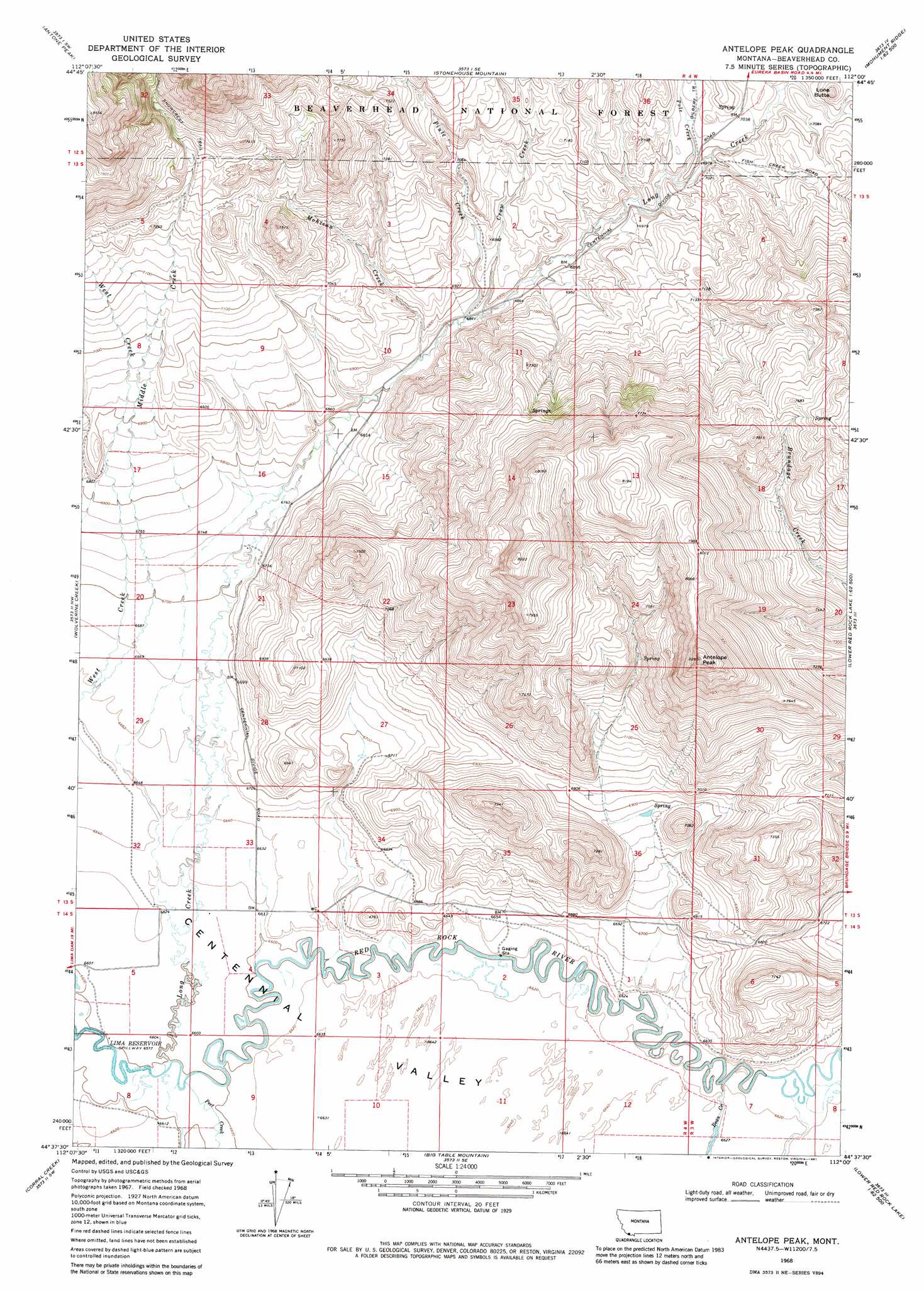
USGS Topo Quad 44112f1 - 1:24,000 scale
| Topo Map Name: | Antelope Peak |
| USGS Topo Quad ID: | 44112f1 |
| Print Size: | ca. 21 1/4" wide x 27" high |
| Southeast Coordinates: | 44.625° N latitude / 112° W longitude |
| Map Center Coordinates: | 44.6875° N latitude / 112.0625° W longitude |
| U.S. State: | MT |
| Filename: | o44112f1.jpg |
| Download Map JPG Image: | Antelope Peak topo map 1:24,000 scale |
| Map Type: | Topographic |
| Topo Series: | 7.5´ |
| Map Scale: | 1:24,000 |
| Source of Map Images: | United States Geological Survey (USGS) |
| Alternate Map Versions: |
Antelope Peak MT 1968, updated 1972 Download PDF Buy paper map Antelope Peak MT 1968, updated 1981 Download PDF Buy paper map Antelope Peak MT 1997, updated 2002 Download PDF Buy paper map Antelope Peak MT 2011 Download PDF Buy paper map Antelope Peak MT 2014 Download PDF Buy paper map |
| FStopo: | US Forest Service topo Antelope Peak is available: Download FStopo PDF Download FStopo TIF |
1:24,000 Topo Quads surrounding Antelope Peak
Price Creek Ne |
Swamp Creek |
Spur Mountain |
Iron Creek |
Bighorn Mountain |
Whiskey Spring |
Antone Peak |
Stonehouse Mountain |
Eureka Basin |
Windy Hill |
Lima Dam |
Wolverine Creek |
Antelope Peak |
Metzel Creek |
Lower Red Rock Lake |
Monida |
Corral Creek |
Big Table Mountain |
Winslow Creek |
Slide Mountain |
Paul Reservoir |
Spencer North |
Lookout Point |
Kilgore |
Antelope Valley |
> Back to 44112e1 at 1:100,000 scale
> Back to 44112a1 at 1:250,000 scale
> Back to U.S. Topo Maps home
Antelope Peak topo map: Gazetteer
Antelope Peak: Streams
Bean Creek elevation 2013m 6604′Crow Creek elevation 2088m 6850′
Long Creek elevation 2012m 6601′
Middle Creek elevation 2031m 6663′
Mohican Creek elevation 2079m 6820′
Peet Creek elevation 2013m 6604′
Piute Creek elevation 2086m 6843′
Pole Creek elevation 2121m 6958′
Antelope Peak: Summits
Antelope Peak elevation 2522m 8274′Lone Butte elevation 2208m 7244′
Antelope Peak: Wells
13S04W17BCDA01 Well elevation 2091m 6860′13S04W28CDDB01 Well elevation 2046m 6712′
Antelope Peak digital topo map on disk
Buy this Antelope Peak topo map showing relief, roads, GPS coordinates and other geographical features, as a high-resolution digital map file on DVD: