Dell Topo Map Montana
To zoom in, hover over the map of Dell
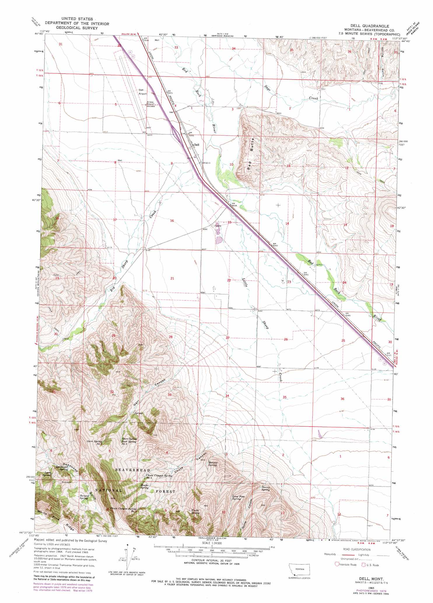
USGS Topo Quad 44112f6 - 1:24,000 scale
| Topo Map Name: | Dell |
| USGS Topo Quad ID: | 44112f6 |
| Print Size: | ca. 21 1/4" wide x 27" high |
| Southeast Coordinates: | 44.625° N latitude / 112.625° W longitude |
| Map Center Coordinates: | 44.6875° N latitude / 112.6875° W longitude |
| U.S. State: | MT |
| Filename: | o44112f6.jpg |
| Download Map JPG Image: | Dell topo map 1:24,000 scale |
| Map Type: | Topographic |
| Topo Series: | 7.5´ |
| Map Scale: | 1:24,000 |
| Source of Map Images: | United States Geological Survey (USGS) |
| Alternate Map Versions: |
Dell MT 1965, updated 1969 Download PDF Buy paper map Dell MT 1965, updated 1979 Download PDF Buy paper map Dell MT 1965, updated 1979 Download PDF Buy paper map Dell MT 2011 Download PDF Buy paper map Dell MT 2014 Download PDF Buy paper map |
| FStopo: | US Forest Service topo Dell is available: Download FStopo PDF Download FStopo TIF |
1:24,000 Topo Quads surrounding Dell
Garfield Canyon |
Red Rock |
Monument Hill |
Beech Creek |
Price Creek |
Deer Canyon |
Kidd |
Briggs Ranch |
Rock Island Ranch |
Vinegar Hill |
Graphite Mountain |
Dixon Mountain |
Dell |
Lima |
Henry Gulch |
Island Butte |
Caboose Canyon |
Gallagher Gulch |
Lima Peaks |
Snowline |
Eighteenmile Peak |
Deadman Lake |
Fritz Peak |
Edie Creek |
Tepee Draw |
> Back to 44112e1 at 1:100,000 scale
> Back to 44112a1 at 1:250,000 scale
> Back to U.S. Topo Maps home
Dell topo map: Gazetteer
Dell: Airports
Dell Flight Strip elevation 1824m 5984′Dell: Bridges
Big Sheep Creek Bridge elevation 1833m 6013′Dell: Crossings
Interchange 23 elevation 1833m 6013′Dell: Mines
McCarthy Gypsum Mine elevation 2332m 7650′Dell: Parks
Dell Park elevation 1832m 6010′Dell: Populated Places
Dell elevation 1832m 6010′Dell: Post Offices
Dell Post Office (historical) elevation 1832m 6010′Dell: Springs
Chute Canyon Spring Number One elevation 2266m 7434′Chute Canyon Spring Number Two elevation 2150m 7053′
Deadwood Spring elevation 2233m 7326′
Fizzle Spring elevation 2249m 7378′
Garr Spring elevation 2189m 7181′
Garr Spring Number Three elevation 2201m 7221′
Garr Spring Number Two elevation 2250m 7381′
Hansen Spring elevation 2059m 6755′
Harper Spring elevation 2386m 7828′
Keefer Spring elevation 2225m 7299′
Lone Pine Spring elevation 2124m 6968′
Lyon Spring elevation 2232m 7322′
Norris Spring elevation 2029m 6656′
Dell: Streams
Big Sheep Creek elevation 1829m 6000′Little Sheep Creek elevation 1835m 6020′
Willow Creek elevation 1886m 6187′
Dell: Summits
Red Butte elevation 1972m 6469′Dell: Valleys
Chute Canyon elevation 1975m 6479′Garr Canyon elevation 1859m 6099′
Norris Canyon elevation 1981m 6499′
Spring Gulch elevation 1861m 6105′
Dell: Wells
13S08W19CDBD01 Well elevation 1872m 6141′13S08W30BCD_01 Well elevation 1865m 6118′
13S09W01BCCA01 Well elevation 1840m 6036′
13S09W04DCDC01 Well elevation 1832m 6010′
13S09W17CBAA01 Well elevation 1866m 6122′
13S09W21DDAD01 Well elevation 1850m 6069′
13S09W22DDDC01 Well elevation 1848m 6062′
13S09W24BDBB01 Well elevation 1852m 6076′
13S09W34BDA_01 Well elevation 1878m 6161′
Dell digital topo map on disk
Buy this Dell topo map showing relief, roads, GPS coordinates and other geographical features, as a high-resolution digital map file on DVD: