Deer Canyon Topo Map Montana
To zoom in, hover over the map of Deer Canyon
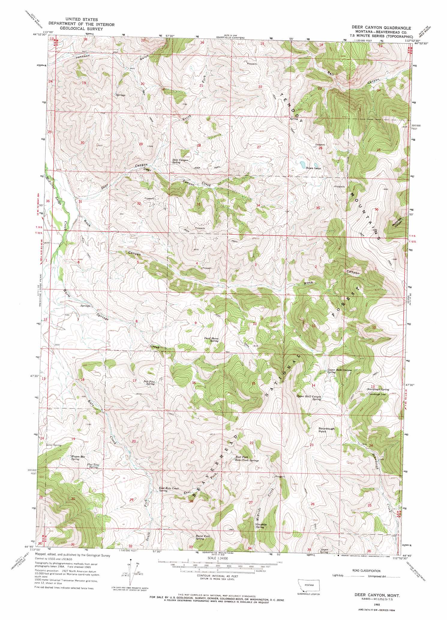
USGS Topo Quad 44112g8 - 1:24,000 scale
| Topo Map Name: | Deer Canyon |
| USGS Topo Quad ID: | 44112g8 |
| Print Size: | ca. 21 1/4" wide x 27" high |
| Southeast Coordinates: | 44.75° N latitude / 112.875° W longitude |
| Map Center Coordinates: | 44.8125° N latitude / 112.9375° W longitude |
| U.S. State: | MT |
| Filename: | o44112g8.jpg |
| Download Map JPG Image: | Deer Canyon topo map 1:24,000 scale |
| Map Type: | Topographic |
| Topo Series: | 7.5´ |
| Map Scale: | 1:24,000 |
| Source of Map Images: | United States Geological Survey (USGS) |
| Alternate Map Versions: |
Deer Canyon MT 1965, updated 1968 Download PDF Buy paper map Deer Canyon MT 1997, updated 2002 Download PDF Buy paper map Deer Canyon MT 2011 Download PDF Buy paper map Deer Canyon MT 2014 Download PDF Buy paper map |
| FStopo: | US Forest Service topo Deer Canyon is available: Download FStopo PDF Download FStopo TIF |
1:24,000 Topo Quads surrounding Deer Canyon
Bachelor Mountain |
Grant |
Eli Spring |
Dalys |
Gallagher Mountain |
Jeff Davis Peak |
Hansen Ranch |
Garfield Canyon |
Red Rock |
Monument Hill |
Deadman Pass |
Medicine Lodge Peak |
Deer Canyon |
Kidd |
Briggs Ranch |
Reservoir Creek |
Tepee Mountain |
Graphite Mountain |
Dixon Mountain |
Dell |
Powderhorn Gulch |
Morrison Lake |
Island Butte |
Caboose Canyon |
Gallagher Gulch |
> Back to 44112e1 at 1:100,000 scale
> Back to 44112a1 at 1:250,000 scale
> Back to U.S. Topo Maps home
Deer Canyon topo map: Gazetteer
Deer Canyon: Capes
Sourdough Point elevation 2602m 8536′Deer Canyon: Lakes
Poison Lakes elevation 2484m 8149′Deer Canyon: Mines
Anderson Mine elevation 2520m 8267′McBride Creek Mine elevation 2522m 8274′
Deer Canyon: Springs
11S10W19BBBC01 Spring elevation 2007m 6584′Aspen Spring elevation 2373m 7785′
Burnt Fork Spring elevation 2340m 7677′
Dead Horse Spring elevation 2363m 7752′
Deer Canyon Spring elevation 2104m 6902′
East Fork Kate Creek Springs elevation 2442m 8011′
East Kate Creek Spring elevation 2154m 7066′
Flat Tire Spring elevation 2164m 7099′
Graphite Spring elevation 2422m 7946′
Line Spring elevation 2166m 7106′
Lower Rock Canyon Spring elevation 2357m 7732′
Nut Pine Spring elevation 2304m 7559′
Sourdough Spring elevation 2585m 8480′
Upper Rock Canyon Spring elevation 2430m 7972′
Wagon Box Spring elevation 2265m 7431′
Deer Canyon: Streams
Deer Canyon Creek elevation 1928m 6325′East Fork Kate Creek elevation 2128m 6981′
North Fork Deer Canyon Creek elevation 2425m 7956′
South Fork Kate Creek elevation 2128m 6981′
Warm Springs Creek elevation 1954m 6410′
Deer Canyon: Valleys
Deer Canyon elevation 1959m 6427′Johnson Gulch elevation 1910m 6266′
Rock Canyon elevation 1952m 6404′
Deer Canyon digital topo map on disk
Buy this Deer Canyon topo map showing relief, roads, GPS coordinates and other geographical features, as a high-resolution digital map file on DVD: