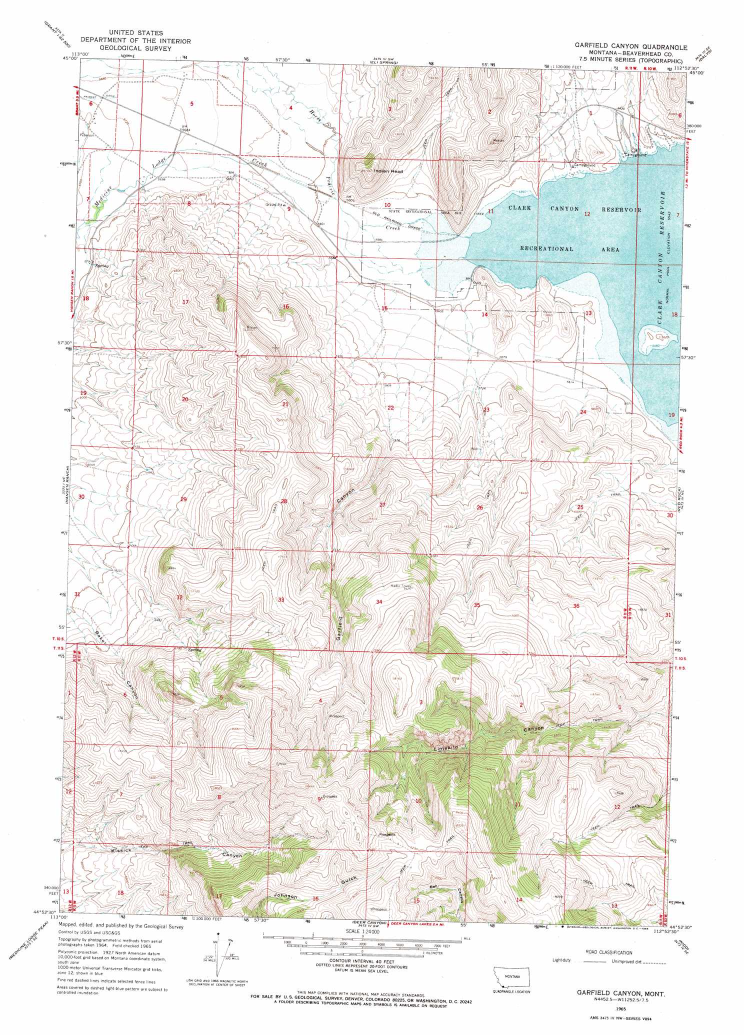
Garfield Canyon Topo Map Montana
To zoom in, hover over the map of Garfield Canyon
USGS Topo Quad 44112h8 - 1:24,000 scale
| Topo Map Name: | Garfield Canyon |
| USGS Topo Quad ID: | 44112h8 |
| Print Size: | ca. 21 1/4" wide x 27" high |
| Southeast Coordinates: | 44.875° N latitude / 112.875° W longitude |
| Map Center Coordinates: | 44.9375° N latitude / 112.9375° W longitude |
| U.S. State: | MT |
| Filename: | o44112h8.jpg |
| Download Map JPG Image: | Garfield Canyon topo map 1:24,000 scale |
| Map Type: | Topographic |
| Topo Series: | 7.5´ |
| Map Scale: | 1:24,000 |
| Source of Map Images: | United States Geological Survey (USGS) |
| Alternate Map Versions: |
Garfield Canyon MT 1965, updated 1965 Download PDF Buy paper map Garfield Canyon MT 2011 Download PDF Buy paper map Garfield Canyon MT 2014 Download PDF Buy paper map |
1:24,000 Topo Quads surrounding Garfield Canyon
Brays Canyon |
Mill Point |
Bannack |
Burns Mountain |
Dillon West |
Bachelor Mountain |
Grant |
Eli Spring |
Dalys |
Gallagher Mountain |
Jeff Davis Peak |
Hansen Ranch |
Garfield Canyon |
Red Rock |
Monument Hill |
Deadman Pass |
Medicine Lodge Peak |
Deer Canyon |
Kidd |
Briggs Ranch |
Reservoir Creek |
Tepee Mountain |
Graphite Mountain |
Dixon Mountain |
Dell |
> Back to 44112e1 at 1:100,000 scale
> Back to 44112a1 at 1:250,000 scale
> Back to U.S. Topo Maps home
Garfield Canyon topo map: Gazetteer
Garfield Canyon: Mines
Clark Canyon Mine elevation 1776m 5826′Clark Canyon Number 2 Mine elevation 1778m 5833′
Garfield Canyon Mine elevation 2403m 7883′
Garfield Canyon: Parks
Clark Canyon Reservoir Recreational Area elevation 1701m 5580′Garfield Canyon: Post Offices
Alice Post Office (historical) elevation 1741m 5711′Medicine Lodge Post Office (historical) elevation 1744m 5721′
Garfield Canyon: Streams
Horse Prairie Creek elevation 1691m 5547′Medicine Lodge Creek elevation 1704m 5590′
Garfield Canyon: Summits
Indian Head elevation 1950m 6397′Garfield Canyon: Valleys
Garfield Canyon elevation 1765m 5790′Garfield Canyon: Wells
10S11W08BCBA01 Well elevation 1743m 5718′Garfield Canyon digital topo map on disk
Buy this Garfield Canyon topo map showing relief, roads, GPS coordinates and other geographical features, as a high-resolution digital map file on DVD: