Medicine Lodge Peak Topo Map Montana
To zoom in, hover over the map of Medicine Lodge Peak
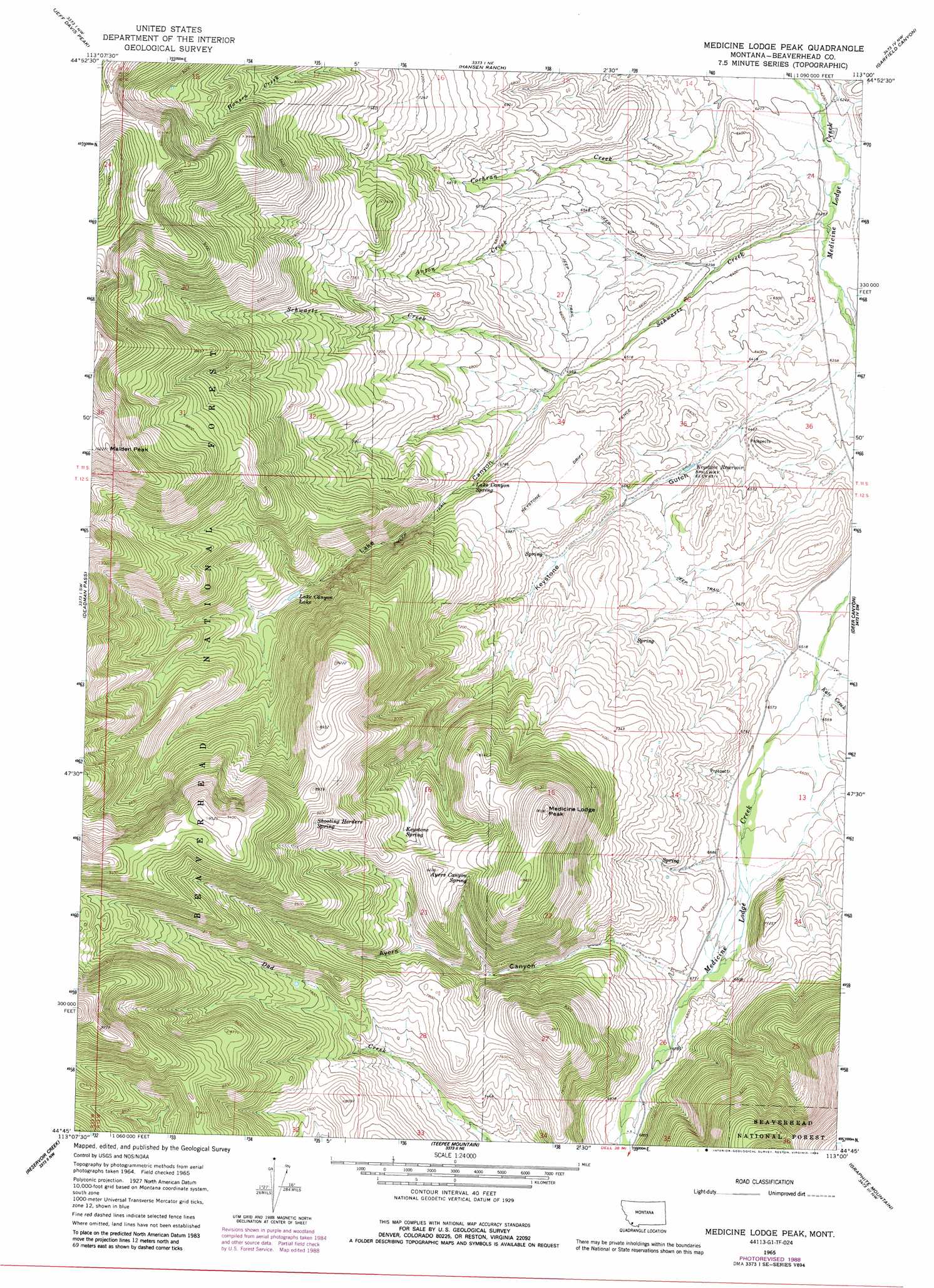
USGS Topo Quad 44113g1 - 1:24,000 scale
| Topo Map Name: | Medicine Lodge Peak |
| USGS Topo Quad ID: | 44113g1 |
| Print Size: | ca. 21 1/4" wide x 27" high |
| Southeast Coordinates: | 44.75° N latitude / 113° W longitude |
| Map Center Coordinates: | 44.8125° N latitude / 113.0625° W longitude |
| U.S. State: | MT |
| Filename: | o44113g1.jpg |
| Download Map JPG Image: | Medicine Lodge Peak topo map 1:24,000 scale |
| Map Type: | Topographic |
| Topo Series: | 7.5´ |
| Map Scale: | 1:24,000 |
| Source of Map Images: | United States Geological Survey (USGS) |
| Alternate Map Versions: |
Medicine Lodge Peak MT 1965, updated 1968 Download PDF Buy paper map Medicine Lodge Peak MT 1965, updated 1989 Download PDF Buy paper map Medicine Lodge Peak MT 1997, updated 2002 Download PDF Buy paper map Medicine Lodge Peak MT 2011 Download PDF Buy paper map Medicine Lodge Peak MT 2014 Download PDF Buy paper map |
| FStopo: | US Forest Service topo Medicine Lodge Peak is available: Download FStopo PDF Download FStopo TIF |
1:24,000 Topo Quads surrounding Medicine Lodge Peak
Coyote Creek |
Bachelor Mountain |
Grant |
Eli Spring |
Dalys |
Everson Creek |
Jeff Davis Peak |
Hansen Ranch |
Garfield Canyon |
Red Rock |
Bannock Pass |
Deadman Pass |
Medicine Lodge Peak |
Deer Canyon |
Kidd |
Leadore |
Reservoir Creek |
Tepee Mountain |
Graphite Mountain |
Dixon Mountain |
Purcell Spring |
Powderhorn Gulch |
Morrison Lake |
Island Butte |
Caboose Canyon |
> Back to 44113e1 at 1:100,000 scale
> Back to 44112a1 at 1:250,000 scale
> Back to U.S. Topo Maps home
Medicine Lodge Peak topo map: Gazetteer
Medicine Lodge Peak: Lakes
Lake Canyon Lake elevation 2234m 7329′Medicine Lodge Peak: Reservoirs
Keystone Reservoir elevation 1986m 6515′Medicine Lodge Peak: Springs
Ayers Canyon Spring elevation 2450m 8038′Keystone Spring elevation 2372m 7782′
Lake Canyon Spring elevation 2064m 6771′
Shooting Herders Spring elevation 2603m 8540′
Medicine Lodge Peak: Streams
Anton Creek elevation 1940m 6364′Kate Creek elevation 1989m 6525′
Schwartz Creek elevation 1902m 6240′
Medicine Lodge Peak: Summits
Maiden Peak elevation 3115m 10219′Medicine Lodge Peak elevation 2761m 9058′
Medicine Lodge Peak: Valleys
Ayers Canyon elevation 2067m 6781′Keystone Gulch elevation 1927m 6322′
Lake Canyon elevation 2011m 6597′
Medicine Lodge Peak digital topo map on disk
Buy this Medicine Lodge Peak topo map showing relief, roads, GPS coordinates and other geographical features, as a high-resolution digital map file on DVD: