Jeff Davis Peak Topo Map Montana
To zoom in, hover over the map of Jeff Davis Peak
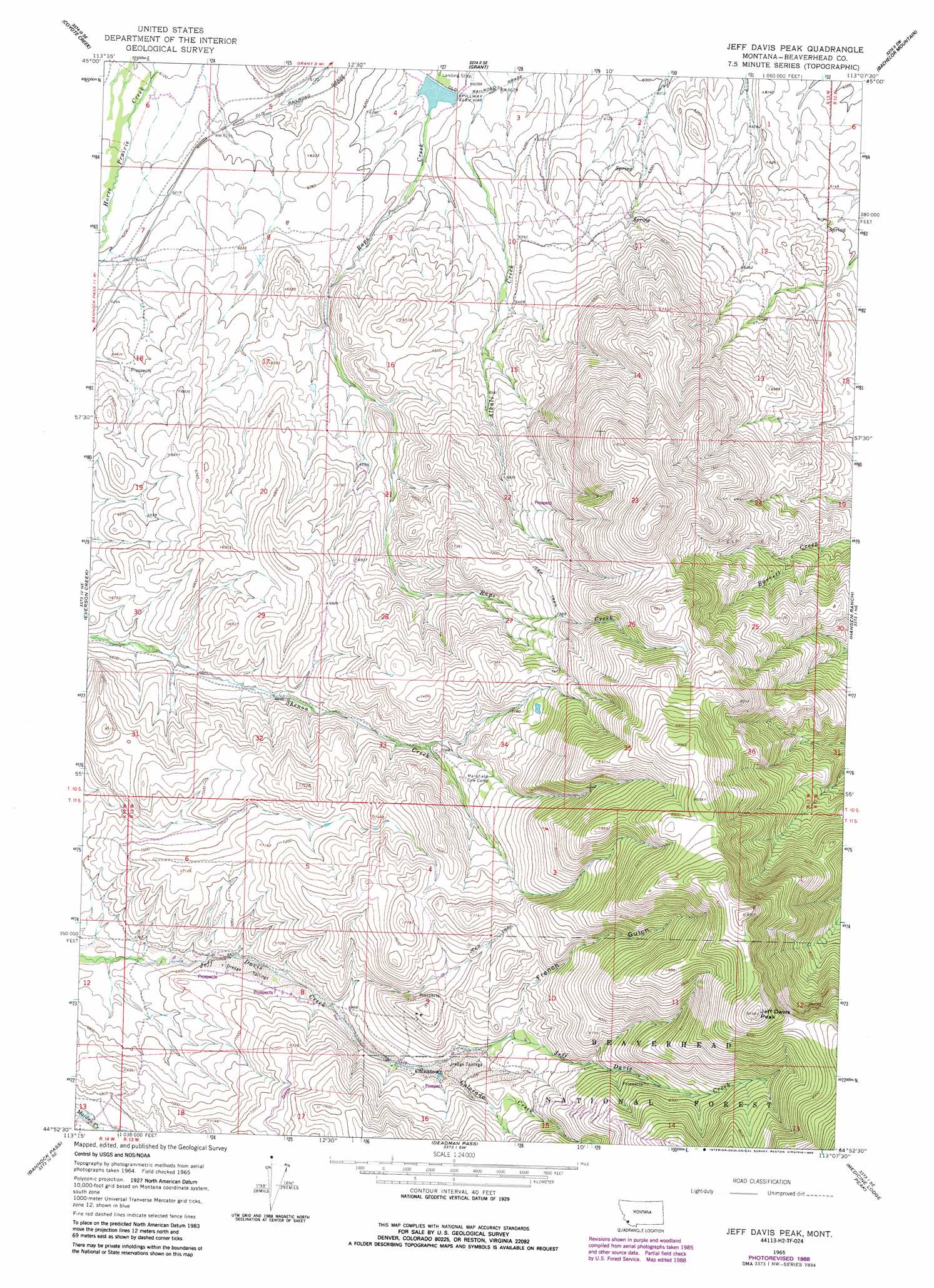
USGS Topo Quad 44113h2 - 1:24,000 scale
| Topo Map Name: | Jeff Davis Peak |
| USGS Topo Quad ID: | 44113h2 |
| Print Size: | ca. 21 1/4" wide x 27" high |
| Southeast Coordinates: | 44.875° N latitude / 113.125° W longitude |
| Map Center Coordinates: | 44.9375° N latitude / 113.1875° W longitude |
| U.S. State: | MT |
| Filename: | o44113h2.jpg |
| Download Map JPG Image: | Jeff Davis Peak topo map 1:24,000 scale |
| Map Type: | Topographic |
| Topo Series: | 7.5´ |
| Map Scale: | 1:24,000 |
| Source of Map Images: | United States Geological Survey (USGS) |
| Alternate Map Versions: |
Jeff Davis Peak MT 1965, updated 1968 Download PDF Buy paper map Jeff Davis Peak MT 1965, updated 1989 Download PDF Buy paper map Jeff Davis Peak MT 2011 Download PDF Buy paper map Jeff Davis Peak MT 2014 Download PDF Buy paper map |
| FStopo: | US Forest Service topo Jeff Davis Peak is available: Download FStopo PDF Download FStopo TIF |
1:24,000 Topo Quads surrounding Jeff Davis Peak
Selway Mountain |
Peterson Lake |
Brays Canyon |
Mill Point |
Bannack |
Kitty Creek |
Coyote Creek |
Bachelor Mountain |
Grant |
Eli Spring |
Lemhi Pass |
Everson Creek |
Jeff Davis Peak |
Hansen Ranch |
Garfield Canyon |
Goat Mountain |
Bannock Pass |
Deadman Pass |
Medicine Lodge Peak |
Deer Canyon |
West Of Leadore |
Leadore |
Reservoir Creek |
Tepee Mountain |
Graphite Mountain |
> Back to 44113e1 at 1:100,000 scale
> Back to 44112a1 at 1:250,000 scale
> Back to U.S. Topo Maps home
Jeff Davis Peak topo map: Gazetteer
Jeff Davis Peak: Dams
J Barrett Dam elevation 1857m 6092′Jeff Davis Peak: Mines
Lucky Strike Mine elevation 2380m 7808′Jeff Davis Peak: Populated Places
Chinatown elevation 2146m 7040′Jeff Davis Peak: Post Offices
Brenner Post Office (historical) elevation 1894m 6213′Jeff Davis Peak: Streams
Colorado Creek elevation 2133m 6998′Jeff Davis Peak: Summits
Jeff Davis Peak elevation 2915m 9563′Jeff Davis Peak: Valleys
French Gulch elevation 2194m 7198′Jeff Davis Peak digital topo map on disk
Buy this Jeff Davis Peak topo map showing relief, roads, GPS coordinates and other geographical features, as a high-resolution digital map file on DVD: