Everson Creek Topo Map Montana
To zoom in, hover over the map of Everson Creek
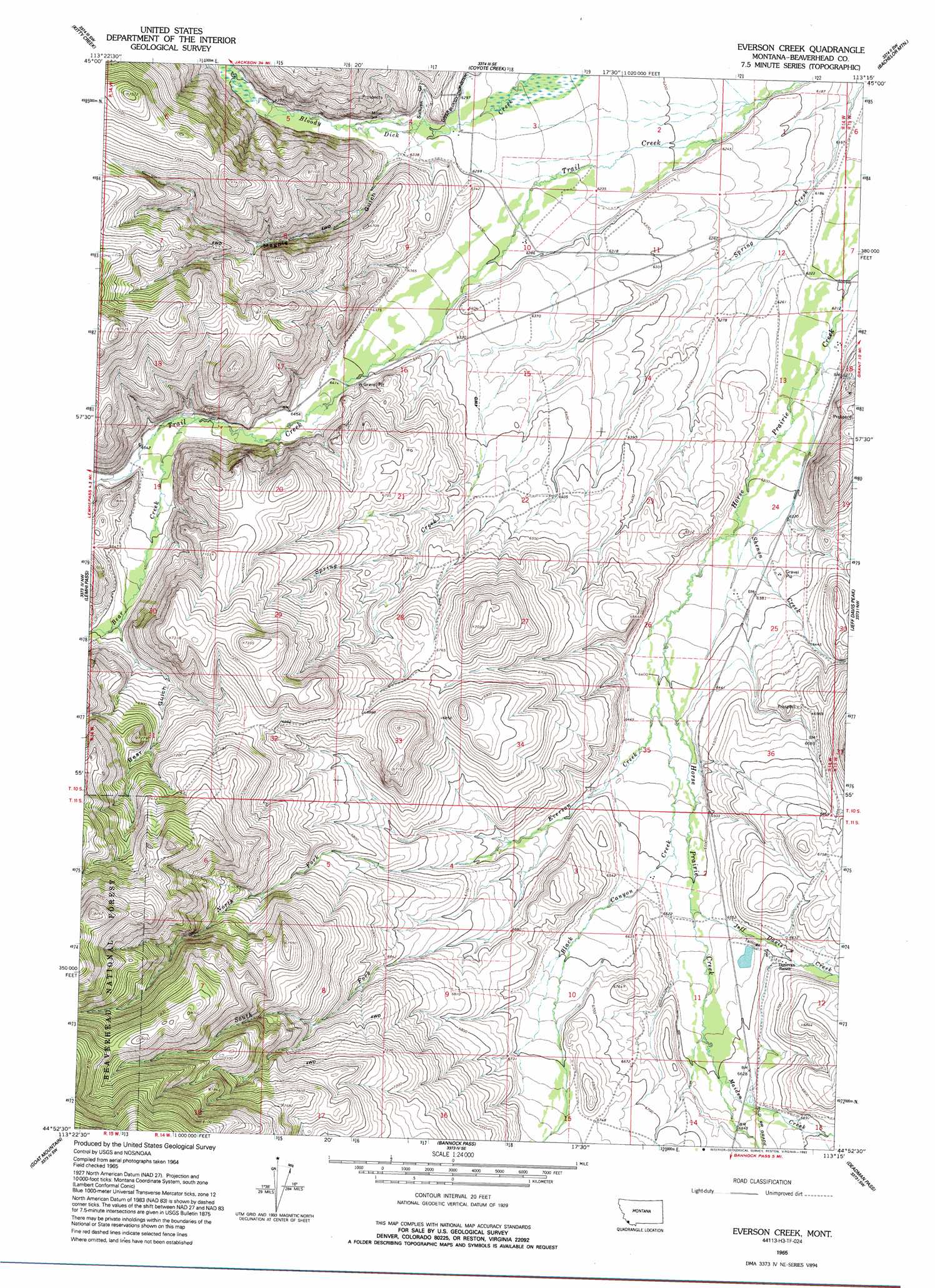
USGS Topo Quad 44113h3 - 1:24,000 scale
| Topo Map Name: | Everson Creek |
| USGS Topo Quad ID: | 44113h3 |
| Print Size: | ca. 21 1/4" wide x 27" high |
| Southeast Coordinates: | 44.875° N latitude / 113.25° W longitude |
| Map Center Coordinates: | 44.9375° N latitude / 113.3125° W longitude |
| U.S. State: | MT |
| Filename: | o44113h3.jpg |
| Download Map JPG Image: | Everson Creek topo map 1:24,000 scale |
| Map Type: | Topographic |
| Topo Series: | 7.5´ |
| Map Scale: | 1:24,000 |
| Source of Map Images: | United States Geological Survey (USGS) |
| Alternate Map Versions: |
Everson Creek MT 1965, updated 1968 Download PDF Buy paper map Everson Creek MT 1965, updated 1993 Download PDF Buy paper map Everson Creek MT 1997, updated 2002 Download PDF Buy paper map Everson Creek MT 2011 Download PDF Buy paper map Everson Creek MT 2014 Download PDF Buy paper map |
| FStopo: | US Forest Service topo Everson Creek is available: Download FStopo PDF Download FStopo TIF |
1:24,000 Topo Quads surrounding Everson Creek
Goldstone Pass |
Selway Mountain |
Peterson Lake |
Brays Canyon |
Mill Point |
Goldstone Mountain |
Kitty Creek |
Coyote Creek |
Bachelor Mountain |
Grant |
Agency Creek |
Lemhi Pass |
Everson Creek |
Jeff Davis Peak |
Hansen Ranch |
Lemhi |
Goat Mountain |
Bannock Pass |
Deadman Pass |
Medicine Lodge Peak |
Stroud Creek |
West Of Leadore |
Leadore |
Reservoir Creek |
Tepee Mountain |
> Back to 44113e1 at 1:100,000 scale
> Back to 44112a1 at 1:250,000 scale
> Back to U.S. Topo Maps home
Everson Creek topo map: Gazetteer
Everson Creek: Airports
Donovan Airstrip elevation 1995m 6545′Everson Creek: Dams
Confederate Dam elevation 2006m 6581′Everson Creek: Mines
Bloody Dick Creek Mine elevation 1996m 6548′NE Section 5 Mine elevation 2158m 7080′
NW Section 4 Mine elevation 2158m 7080′
Starlight Mine elevation 2025m 6643′
Everson Creek: Post Offices
Donovan Ranch Post Office (historical) elevation 2018m 6620′Horse Prairie Post Office (historical) elevation 2025m 6643′
Monument Post Office (historical) elevation 1920m 6299′
Everson Creek: Streams
Bear Creek elevation 1985m 6512′Black Canyon Creek elevation 1955m 6414′
Everson Creek elevation 1948m 6391′
Jeff Davis Creek elevation 1988m 6522′
Maiden Creek elevation 2013m 6604′
North Fork Everson Creek elevation 1986m 6515′
North Fork Maiden Creek elevation 2033m 6669′
Shenon Creek elevation 1901m 6236′
South Fork Everson Creek elevation 1986m 6515′
Everson Creek: Valleys
Bear Gulch elevation 2039m 6689′Magpie Gulch elevation 1939m 6361′
Sullivan Gulch elevation 1926m 6318′
Everson Creek: Wells
10S14W03BBCB01 Well elevation 1920m 6299′10S14W10BDAD01 Well elevation 1915m 6282′
10S14W23CDBB01 Well elevation 1960m 6430′
Everson Creek digital topo map on disk
Buy this Everson Creek topo map showing relief, roads, GPS coordinates and other geographical features, as a high-resolution digital map file on DVD: