Lemhi Pass Topo Map Montana
To zoom in, hover over the map of Lemhi Pass
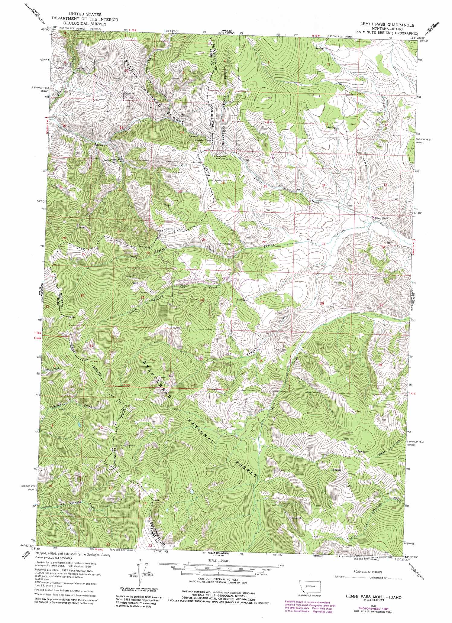
USGS Topo Quad 44113h4 - 1:24,000 scale
| Topo Map Name: | Lemhi Pass |
| USGS Topo Quad ID: | 44113h4 |
| Print Size: | ca. 21 1/4" wide x 27" high |
| Southeast Coordinates: | 44.875° N latitude / 113.375° W longitude |
| Map Center Coordinates: | 44.9375° N latitude / 113.4375° W longitude |
| U.S. States: | MT, ID |
| Filename: | o44113h4.jpg |
| Download Map JPG Image: | Lemhi Pass topo map 1:24,000 scale |
| Map Type: | Topographic |
| Topo Series: | 7.5´ |
| Map Scale: | 1:24,000 |
| Source of Map Images: | United States Geological Survey (USGS) |
| Alternate Map Versions: |
Lemhi Pass MT 1965, updated 1968 Download PDF Buy paper map Lemhi Pass MT 1965, updated 1979 Download PDF Buy paper map Lemhi Pass MT 1965, updated 1989 Download PDF Buy paper map Lemhi Pass MT 1997, updated 2002 Download PDF Buy paper map Lemhi Pass MT 2011 Download PDF Buy paper map Lemhi Pass MT 2014 Download PDF Buy paper map |
| FStopo: | US Forest Service topo Lemhi Pass is available: Download FStopo PDF Download FStopo TIF |
1:24,000 Topo Quads surrounding Lemhi Pass
Bohannon Spring |
Goldstone Pass |
Selway Mountain |
Peterson Lake |
Brays Canyon |
Baker |
Goldstone Mountain |
Kitty Creek |
Coyote Creek |
Bachelor Mountain |
Tendoy |
Agency Creek |
Lemhi Pass |
Everson Creek |
Jeff Davis Peak |
Hayden Creek |
Lemhi |
Goat Mountain |
Bannock Pass |
Deadman Pass |
Mogg Mountain |
Stroud Creek |
West Of Leadore |
Leadore |
Reservoir Creek |
> Back to 44113e1 at 1:100,000 scale
> Back to 44112a1 at 1:250,000 scale
> Back to U.S. Topo Maps home
Lemhi Pass topo map: Gazetteer
Lemhi Pass: Gaps
Lemhi Pass elevation 2250m 7381′Lemhi Pass elevation 2246m 7368′
Lemhi Pass: Mines
Copper Queen Mine elevation 1888m 6194′Last Chance Number One Mine elevation 2353m 7719′
Lemhi Pass: Springs
Distant Fountain elevation 2215m 7267′Lemhi Pass: Streams
Frying Pan Creek elevation 2018m 6620′Horseshoe Bend Creek elevation 1959m 6427′
North Frying Pan Creek elevation 2109m 6919′
Sheser Creek elevation 2018m 6620′
South Frying Pan Creek elevation 2105m 6906′
Trapper Creek elevation 2034m 6673′
Lemhi Pass digital topo map on disk
Buy this Lemhi Pass topo map showing relief, roads, GPS coordinates and other geographical features, as a high-resolution digital map file on DVD: