Bowery Peak Topo Map Idaho
To zoom in, hover over the map of Bowery Peak
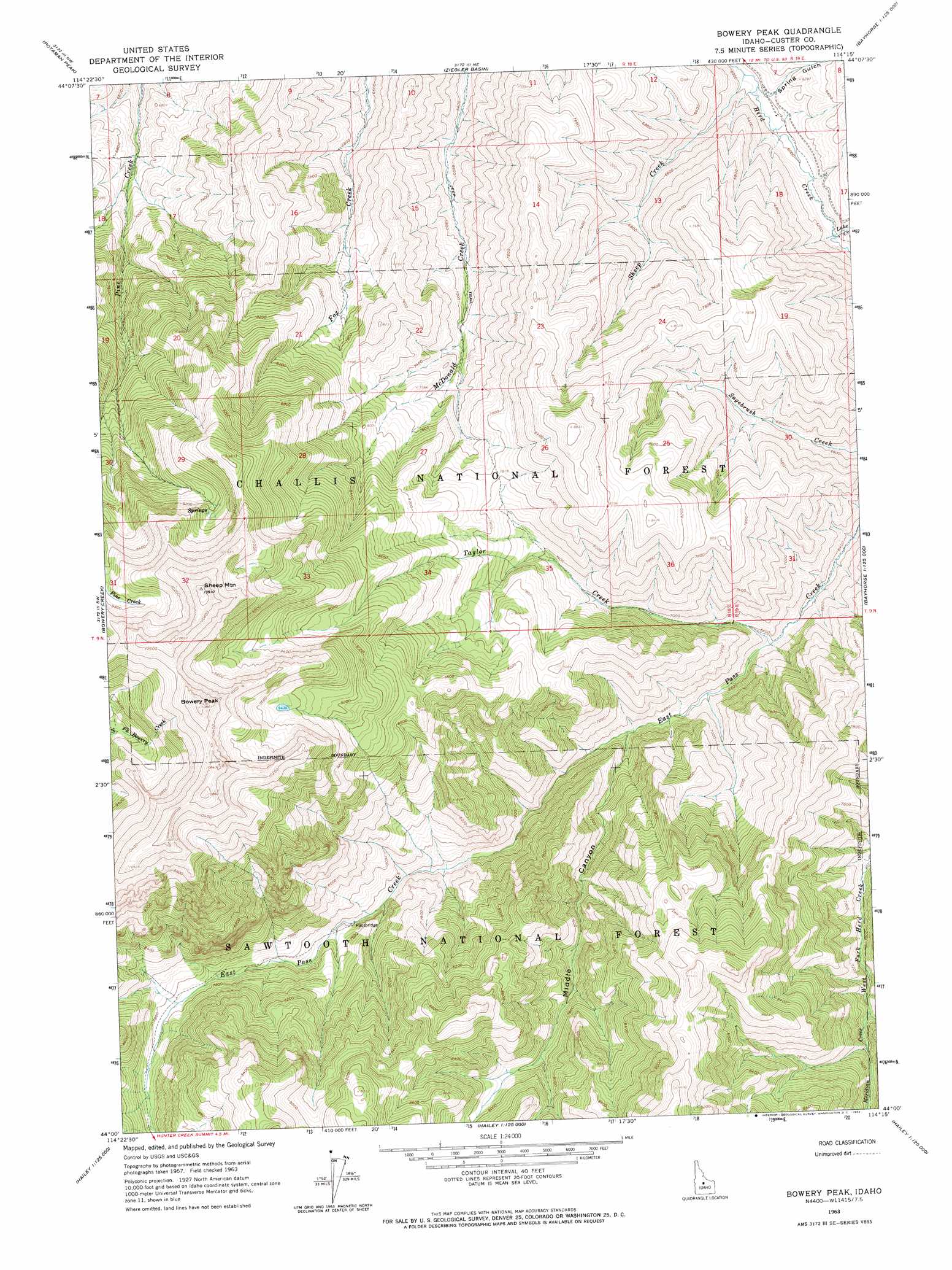
USGS Topo Quad 44114a3 - 1:24,000 scale
| Topo Map Name: | Bowery Peak |
| USGS Topo Quad ID: | 44114a3 |
| Print Size: | ca. 21 1/4" wide x 27" high |
| Southeast Coordinates: | 44° N latitude / 114.25° W longitude |
| Map Center Coordinates: | 44.0625° N latitude / 114.3125° W longitude |
| U.S. State: | ID |
| Filename: | o44114a3.jpg |
| Download Map JPG Image: | Bowery Peak topo map 1:24,000 scale |
| Map Type: | Topographic |
| Topo Series: | 7.5´ |
| Map Scale: | 1:24,000 |
| Source of Map Images: | United States Geological Survey (USGS) |
| Alternate Map Versions: |
Bowery Peak ID 1963, updated 1964 Download PDF Buy paper map Bowery Peak ID 2011 Download PDF Buy paper map Bowery Peak ID 2013 Download PDF Buy paper map |
| FStopo: | US Forest Service topo Bowery Peak is available: Download FStopo PDF Download FStopo TIF |
1:24,000 Topo Quads surrounding Bowery Peak
Thompson Creek |
Clayton |
Bald Mountain |
Lone Pine Peak |
Antelope Flat |
Livingston Creek |
Potaman Peak |
Ziegler Basin |
The Paint Pot |
Horse Basin |
Boulder Chain Lakes |
Bowery Creek |
Bowery Peak |
Herd Lake |
Jerry Peak |
Galena Peak |
Ryan Peak |
Meridian Peak |
Herd Peak |
Harry Canyon |
Easley Hot Springs |
Amber Lakes |
Rock Roll Canyon |
Phi Kappa Mountain |
Standhope Peak |
> Back to 44114a1 at 1:100,000 scale
> Back to 44114a1 at 1:250,000 scale
> Back to U.S. Topo Maps home
Bowery Peak topo map: Gazetteer
Bowery Peak: Bridges
Sheep Bridge elevation 2234m 7329′Bowery Peak: Streams
Lake Creek elevation 1851m 6072′Meridian Creek elevation 2149m 7050′
Sheep Creek elevation 1812m 5944′
Taylor Creek elevation 1961m 6433′
Bowery Peak: Summits
Bowery Peak elevation 3309m 10856′Sheep Mountain elevation 3325m 10908′
Bowery Peak: Valleys
Middle Canyon elevation 2034m 6673′Spring Gulch elevation 1840m 6036′
Bowery Peak digital topo map on disk
Buy this Bowery Peak topo map showing relief, roads, GPS coordinates and other geographical features, as a high-resolution digital map file on DVD: