Obsidian Topo Map Idaho
To zoom in, hover over the map of Obsidian
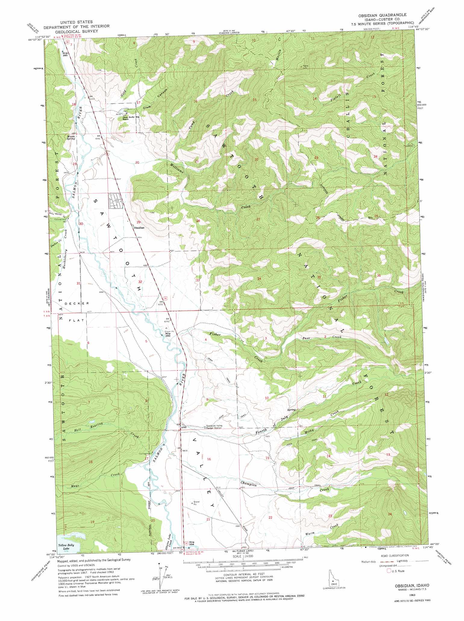
USGS Topo Quad 44114a7 - 1:24,000 scale
| Topo Map Name: | Obsidian |
| USGS Topo Quad ID: | 44114a7 |
| Print Size: | ca. 21 1/4" wide x 27" high |
| Southeast Coordinates: | 44° N latitude / 114.75° W longitude |
| Map Center Coordinates: | 44.0625° N latitude / 114.8125° W longitude |
| U.S. State: | ID |
| Filename: | o44114a7.jpg |
| Download Map JPG Image: | Obsidian topo map 1:24,000 scale |
| Map Type: | Topographic |
| Topo Series: | 7.5´ |
| Map Scale: | 1:24,000 |
| Source of Map Images: | United States Geological Survey (USGS) |
| Alternate Map Versions: |
Obsidian ID 1963, updated 1965 Download PDF Buy paper map Obsidian ID 1963, updated 1975 Download PDF Buy paper map Obsidian ID 1963, updated 1975 Download PDF Buy paper map Obsidian ID 2011 Download PDF Buy paper map Obsidian ID 2013 Download PDF Buy paper map |
| FStopo: | US Forest Service topo Obsidian is available: Download FStopo PDF Download FStopo TIF |
1:24,000 Topo Quads surrounding Obsidian
Elk Meadow |
Basin Butte |
East Basin Creek |
Sunbeam |
Thompson Creek |
Stanley Lake |
Stanley |
Casino Lakes |
Robinson Bar |
Livingston Creek |
Warbonnet Peak |
Mount Cramer |
Obsidian |
Washington Peak |
Boulder Chain Lakes |
Mount Everly |
Snowyside Peak |
Alturas Lake |
Horton Peak |
Galena Peak |
Atlanta East |
Marshall Peak |
Frenchman Creek |
Galena |
Easley Hot Springs |
> Back to 44114a1 at 1:100,000 scale
> Back to 44114a1 at 1:250,000 scale
> Back to U.S. Topo Maps home
Obsidian topo map: Gazetteer
Obsidian: Dams
Yellow Belly Lake Fish Barrier Dam elevation 2158m 7080′Obsidian: Flats
Decker Flat elevation 2034m 6673′Obsidian: Populated Places
Obsidian elevation 2030m 6660′Obsidian: Streams
Alturas Lake Creek elevation 2078m 6817′Camp Creek elevation 2056m 6745′
Champion Creek elevation 2064m 6771′
Decker Creek elevation 2022m 6633′
Fisher Creek elevation 2047m 6715′
Fourth of July Creek elevation 2059m 6755′
Gold Creek elevation 1997m 6551′
Hell Roaring Creek elevation 2065m 6774′
Huckleberry Creek elevation 2012m 6601′
Mays Creek elevation 2067m 6781′
Milky Creek elevation 2181m 7155′
Pass Creek elevation 2149m 7050′
Williams Creek elevation 2004m 6574′
Obsidian: Valleys
Club Canyon elevation 2012m 6601′Obsidian digital topo map on disk
Buy this Obsidian topo map showing relief, roads, GPS coordinates and other geographical features, as a high-resolution digital map file on DVD: