Mount Cramer Topo Map Idaho
To zoom in, hover over the map of Mount Cramer
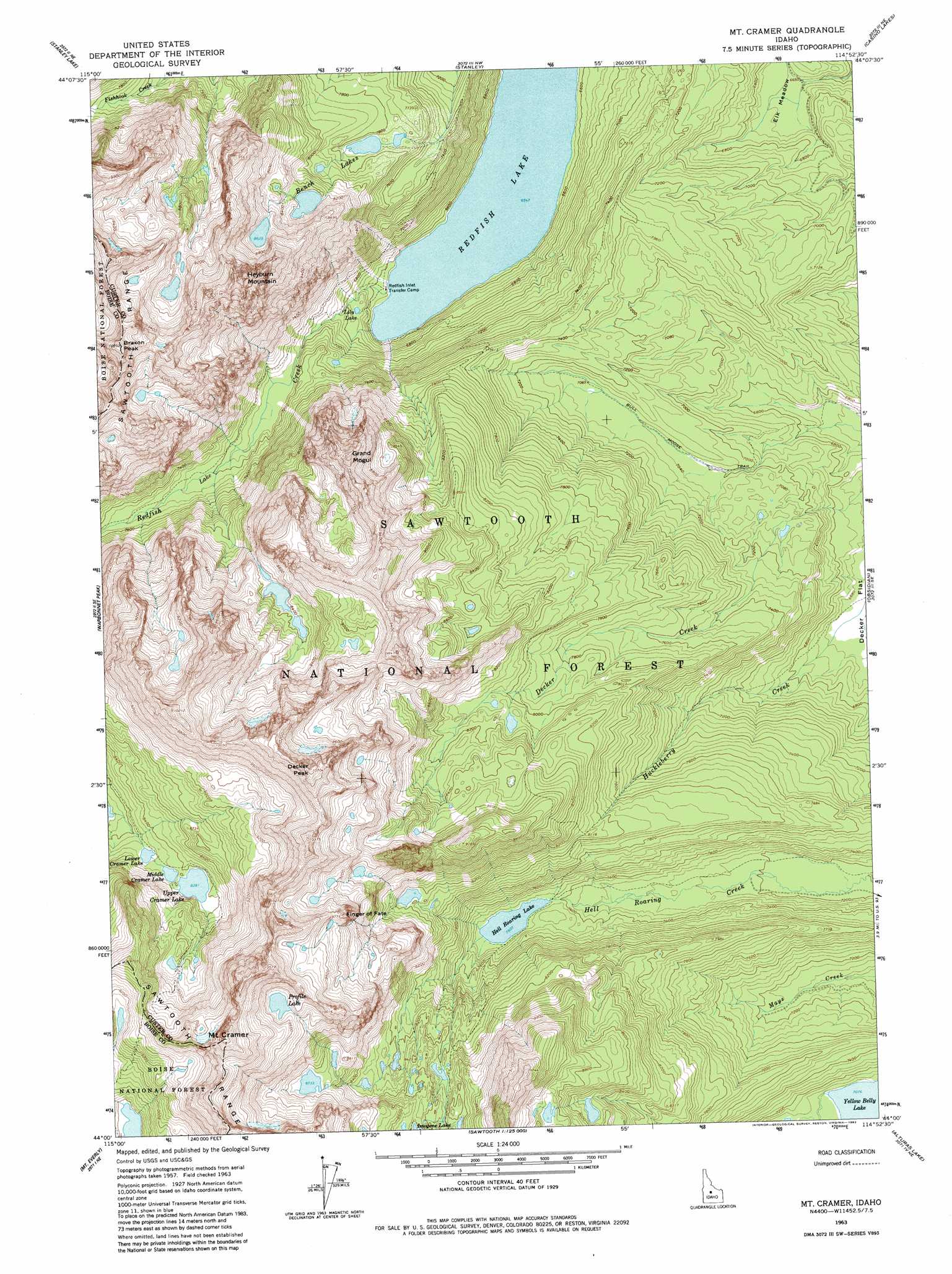
USGS Topo Quad 44114a8 - 1:24,000 scale
| Topo Map Name: | Mount Cramer |
| USGS Topo Quad ID: | 44114a8 |
| Print Size: | ca. 21 1/4" wide x 27" high |
| Southeast Coordinates: | 44° N latitude / 114.875° W longitude |
| Map Center Coordinates: | 44.0625° N latitude / 114.9375° W longitude |
| U.S. State: | ID |
| Filename: | o44114a8.jpg |
| Download Map JPG Image: | Mount Cramer topo map 1:24,000 scale |
| Map Type: | Topographic |
| Topo Series: | 7.5´ |
| Map Scale: | 1:24,000 |
| Source of Map Images: | United States Geological Survey (USGS) |
| Alternate Map Versions: |
Mt Cramer ID 1963, updated 1964 Download PDF Buy paper map Mt Cramer ID 1963, updated 1973 Download PDF Buy paper map Mt Cramer ID 1963, updated 1982 Download PDF Buy paper map Mt Cramer ID 1963, updated 1982 Download PDF Buy paper map Mt Cramer ID 1963, updated 1982 Download PDF Buy paper map Mount Cramer ID 2011 Download PDF Buy paper map Mount Cramer ID 2013 Download PDF Buy paper map |
| FStopo: | US Forest Service topo Mount Cramer is available: Download FStopo PDF Download FStopo TIF |
1:24,000 Topo Quads surrounding Mount Cramer
Banner Summit |
Elk Meadow |
Basin Butte |
East Basin Creek |
Sunbeam |
Grandjean |
Stanley Lake |
Stanley |
Casino Lakes |
Robinson Bar |
Edaho Mountain |
Warbonnet Peak |
Mount Cramer |
Obsidian |
Washington Peak |
Nahneke Mountain |
Mount Everly |
Snowyside Peak |
Alturas Lake |
Horton Peak |
Atlanta West |
Atlanta East |
Marshall Peak |
Frenchman Creek |
Galena |
> Back to 44114a1 at 1:100,000 scale
> Back to 44114a1 at 1:250,000 scale
> Back to U.S. Topo Maps home
Mount Cramer topo map: Gazetteer
Mount Cramer: Flats
Elk Meadow elevation 2033m 6669′Mount Cramer: Lakes
Baron Lake elevation 2688m 8818′Bench Lakes elevation 2495m 8185′
Hell Roaring Lake elevation 2259m 7411′
Hidden Lake elevation 2612m 8569′
Lily Lake elevation 2054m 6738′
Lower Cramer Lake elevation 2533m 8310′
Middle Cramer Lake elevation 2547m 8356′
Profile Lake elevation 2897m 9504′
Redfish Lake elevation 1997m 6551′
Saddleback Lakes elevation 2543m 8343′
Upper Baron Lake elevation 2525m 8284′
Upper Cramer Lake elevation 2556m 8385′
Yellow Belly Lake elevation 2158m 7080′
Mount Cramer: Pillars
Finger of Fate elevation 2976m 9763′Mount Cramer: Summits
Braxon Peak elevation 3151m 10337′Decker Peak elevation 3241m 10633′
Grand Mogul elevation 2958m 9704′
Heyburn Mountain elevation 3082m 10111′
Mount Cramer elevation 3252m 10669′
Sevy Peak elevation 3184m 10446′
Sexy Peak elevation 3159m 10364′
The Arrowhead elevation 3117m 10226′
The Temple elevation 2986m 9796′
Mount Cramer: Trails
Bull Moose Trail elevation 2147m 7043′Mount Cramer digital topo map on disk
Buy this Mount Cramer topo map showing relief, roads, GPS coordinates and other geographical features, as a high-resolution digital map file on DVD: