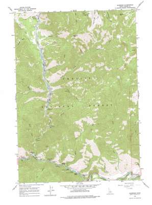
Sunbeam Topo Map Idaho
To zoom in, hover over the map of Sunbeam
USGS Topo Quad 44114c6 - 1:24,000 scale
| Topo Map Name: | Sunbeam |
| USGS Topo Quad ID: | 44114c6 |
| Print Size: | ca. 21 1/4" wide x 27" high |
| Southeast Coordinates: | 44.25° N latitude / 114.625° W longitude |
| Map Center Coordinates: | 44.3125° N latitude / 114.6875° W longitude |
| U.S. State: | ID |
| Filename: | o44114c6.jpg |
| Download Map JPG Image: | Sunbeam topo map 1:24,000 scale |
| Map Type: | Topographic |
| Topo Series: | 7.5´ |
| Map Scale: | 1:24,000 |
| Source of Map Images: | United States Geological Survey (USGS) |
| Alternate Map Versions: |
Sunbeam ID 1964, updated 1966 Download PDF Buy paper map Sunbeam ID 1964, updated 1978 Download PDF Buy paper map Sunbeam ID 1964, updated 1978 Download PDF Buy paper map Sunbeam ID 2011 Download PDF Buy paper map Sunbeam ID 2013 Download PDF Buy paper map |
| FStopo: | US Forest Service topo Sunbeam is available: Download FStopo PDF Download FStopo TIF |
1:24,000 Topo Quads surrounding Sunbeam
> Back to 44114a1 at 1:100,000 scale
> Back to 44114a1 at 1:250,000 scale
> Back to U.S. Topo Maps home
Sunbeam topo map: Gazetteer
Sunbeam: Dams
Sunbeam Dam (historical) elevation 1814m 5951′Sunbeam: Mines
Lucky Boy Mine elevation 2438m 7998′Sunbeam: Populated Places
Bonanza elevation 1943m 6374′Sunbeam elevation 1827m 5994′
Sunbeam: Post Offices
Sunbeam Post Office (historical) elevation 1827m 5994′Sunbeam: Rapids
Indian Riffles elevation 1774m 5820′Sunbeam: Springs
Snyder Springs elevation 1780m 5839′Stovepipe Spring elevation 1793m 5882′
Sunbeam Hot Springs elevation 1837m 6026′
Sunbeam: Streams
Blind Creek elevation 1821m 5974′Cearley Creek elevation 1904m 6246′
Elk Creek elevation 1793m 5882′
Jerrys Creek elevation 1891m 6204′
Marshall Creek elevation 1778m 5833′
Muley Creek elevation 1785m 5856′
Peach Creek elevation 1755m 5757′
Polecamp Creek elevation 1867m 6125′
Ramey Creek elevation 1886m 6187′
Rankin Creek elevation 1884m 6181′
Sawmill Creek elevation 1917m 6289′
Silver Creek elevation 1884m 6181′
Treon Creek elevation 1748m 5734′
Warm Springs Creek elevation 1772m 5813′
West Fork Yankee Fork elevation 1909m 6263′
Yankee Fork elevation 1803m 5915′
Sunbeam: Summits
Bachelor Mountain elevation 2869m 9412′Bonanza Peak elevation 2823m 9261′
Sunbeam: Valleys
Aspen Gulch elevation 1824m 5984′Preachers Cove elevation 1940m 6364′
Sunbeam digital topo map on disk
Buy this Sunbeam topo map showing relief, roads, GPS coordinates and other geographical features, as a high-resolution digital map file on DVD:


