Meyers Cove Point Topo Map Idaho
To zoom in, hover over the map of Meyers Cove Point
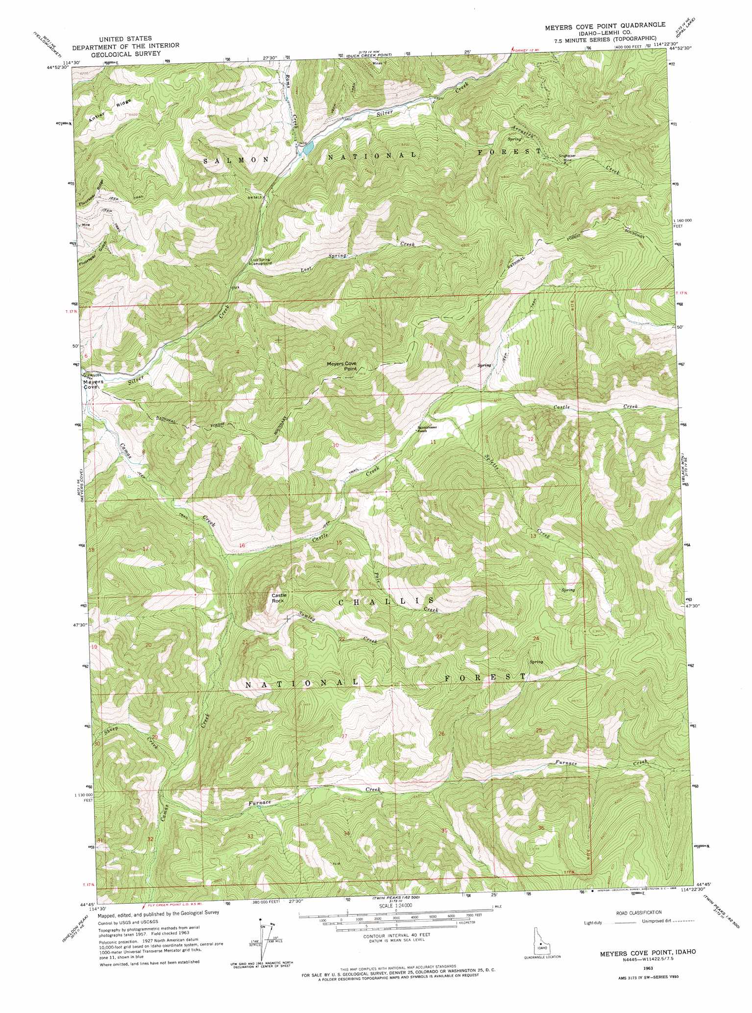
USGS Topo Quad 44114g4 - 1:24,000 scale
| Topo Map Name: | Meyers Cove Point |
| USGS Topo Quad ID: | 44114g4 |
| Print Size: | ca. 21 1/4" wide x 27" high |
| Southeast Coordinates: | 44.75° N latitude / 114.375° W longitude |
| Map Center Coordinates: | 44.8125° N latitude / 114.4375° W longitude |
| U.S. State: | ID |
| Filename: | o44114g4.jpg |
| Download Map JPG Image: | Meyers Cove Point topo map 1:24,000 scale |
| Map Type: | Topographic |
| Topo Series: | 7.5´ |
| Map Scale: | 1:24,000 |
| Source of Map Images: | United States Geological Survey (USGS) |
| Alternate Map Versions: |
Meyers Cove Point ID 1963, updated 1965 Download PDF Buy paper map Meyers Cove Point ID 2011 Download PDF Buy paper map Meyers Cove Point ID 2013 Download PDF Buy paper map |
| FStopo: | US Forest Service topo Meyers Cove Point is available: Download FStopo PDF Download FStopo TIF |
1:24,000 Topo Quads surrounding Meyers Cove Point
Puddin Mountain |
Hoodoo Meadows |
Blackbird Mountain |
Blackbird Creek |
Cobalt |
Aparejo Point |
Yellowjacket |
Duck Creek Point |
Opal Lake |
Taylor Mountain |
Sleeping Deer Mountain |
Meyers Cove |
Meyers Cove Point |
Black Mountain |
Wards Butte |
Rock Creek |
Sheldon Peak |
White Goat Mountain |
Blowfly Creek |
Gooseberry Creek |
Sherman Peak |
Challis Creek Lakes |
Twin Peaks |
Pats Creek |
Challis |
> Back to 44114e1 at 1:100,000 scale
> Back to 44114a1 at 1:250,000 scale
> Back to U.S. Topo Maps home
Meyers Cove Point topo map: Gazetteer
Meyers Cove Point: Cliffs
Meyers Cove Point elevation 2411m 7910′Meyers Cove Point: Dams
Boggeman Dam elevation 1657m 5436′Meyers Cove Point: Mines
Singheiser Mine elevation 1956m 6417′Meyers Cove Point: Pillars
Castle Rock elevation 2158m 7080′Meyers Cove Point: Ridges
Antler Ridge elevation 2038m 6686′Meyers Cove Point: Streams
Arrastra Creek elevation 1697m 5567′Castle Creek elevation 1614m 5295′
Furnace Creek elevation 1706m 5597′
Lost Spring Creek elevation 1621m 5318′
Pole Creek elevation 1695m 5561′
Rams Creek elevation 1655m 5429′
Sawlog Creek elevation 1632m 5354′
Sheep Creek elevation 1692m 5551′
Spletts Creek elevation 1802m 5912′
Meyers Cove Point digital topo map on disk
Buy this Meyers Cove Point topo map showing relief, roads, GPS coordinates and other geographical features, as a high-resolution digital map file on DVD: